
Blair County is a county located in the U.S. Commonwealth of Pennsylvania. As of the 2010 census, the population was 127,089. Its county seat is Hollidaysburg. The county was created on February 26, 1846, from parts of Huntingdon and Bedford Counties.
Woodbury is a borough in Bedford County, Pennsylvania, United States. The population was 284 at the 2010 census.

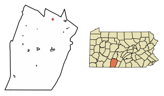
Martinsburg is a borough in the Morrisons Cove section of Blair County, Pennsylvania, United States. The population was 1,958 at the 2010 census. It is part of the Altoona, PA Metropolitan Statistical Area.
Morrison's or Morrisons may refer to:
Yellow Creek is a 20.9-mile-long (33.6 km) tributary of the Raystown Branch Juniata River in Bedford County, Pennsylvania, in the United States.
Clover Creek is a 24.5-mile-long (39.4 km) tributary of the Frankstown Branch Juniata River in Bedford and Blair counties, Pennsylvania, in the United States.
The Oyster Bay Branch is a rail line and service owned and operated by the Long Island Rail Road in the U.S. state of New York. The branch splits from the Main Line just east of Mineola station, and runs north and east to Oyster Bay. The branch is electrified between East Williston and Mineola.

The Nittany Valley is an eroded anticlinal valley in the central portion of Centre County, Pennsylvania in the United States. It is separated from the Bald Eagle Valley by Bald Eagle Mountain and from Penns Valley by Mount Nittany. The valley is closed to the north by a high plateau that joins these two mountain ridges, but is open to the south at the southern terminus of Mount Nittany. The valley drains to the Bald Eagle Creek through water gaps in Bald Eagle Mountain formed by Spring Creek, and Fishing Creek, along with smaller streams running through Curtain Gap and Howard Gap. The Northwest side of the valley between the Bald Eagle Mountain ridge and the lower Sand Ridge is also known as the "Little Nittany Valley".
Morrisons Cove, is an eroded anticlinal valley in Blair and Bedford counties of central Pennsylvania, United States, extending from Evitts Mountain near New Enterprise, north to the Frankstown Branch Juniata River at Williamsburg. The width of the valley varies from 10 to 15 miles between Tussey Mountain on the east to the chain of Dunning, Loop and Lock Mountains on the west. Almost entirely enclosed by these mountains, the only openings in the cove are at Loysburg Gap in the south, McKee Gap in the west, and at Williamsburg to the north. The floor of the valley is mostly level, with many large fertile farm fields. The southern end of the valley drains to the Raystown Branch Juniata River via Yellow Creek through Loysburg Gap, and the northern end drains to the Frankstown Branch, via Clover Creek.

Evitts Mountain is a stratigraphic ridge in the Ridge and Valley region of the Appalachian Mountains, located in Bedford County, Pennsylvania, and Allegany County, Maryland.

Wills Mountain is a quartzite-capped ridge in the Ridge and Valley physiographic province of the Appalachian Mountains in Pennsylvania and Maryland, United States, extending from near Bedford, Pennsylvania, to near Cumberland, Maryland. It is the northernmost of several mountain ridges included within the Wills Mountain Anticline.

Loysburg is an unincorporated community in the Morrisons Cove area of South Woodbury Township, Bedford County, Pennsylvania, United States. It lies along Pennsylvania Route 36 and the Yellow Creek near the Loysburg Gap in Tussey Mountain. Once named "Pattonville" in 1844 but was renamed back to Loyburg in 1864. Northern Bedford County Middle/High School is located in the area.

Big Mountain is the high point on the Tuscarora Mountain ridge in south central Pennsylvania in the United States. The 2,458-foot (749 m) summit is located in the Buchanan State Forest and offers an viewshed that is one of the more stunning in the Commonwealth.
Central High School in Martinsburg, Pennsylvania is the smallest of the three Central High Schools in the commonwealth of Pennsylvania with 674 students in four grades (9-12). Central High opened in 1960 with the merging of Roaring Spring High School, Morrison Cove High School, and Martinsburg High School; becoming the first and only high school in Spring Cove School District history.

The Everett Railroad is a shortline and heritage railroad that operates on ex-Pennsylvania Railroad trackage in the Hollidaysburg area of the U.S. state of Pennsylvania. It runs freight trains over two separate lines, one from Brooks Mill and Sproul, and the other, owned by the Morrison's Cove Railroad, from Roaring Spring to Curryville and Martinsburg. The affiliated Hollidaysburg and Roaring Spring Railroad, which the Everett Railroad operates both under contract and via trackage rights, connects the two segments to each other and to the Norfolk Southern Railway (ex-Conrail) in Hollidaysburg. The Everett Railroad name refers to its former location near Everett, abandoned in 1982.

D. O. Lee Peak, also known as Lee Peak, at 11,347 feet (3,459 m) above sea level, is the third-highest peak in the White Cloud Mountains of the U.S. state of Idaho. It is one of the White Cloud Peaks and the 56th-highest peak in Idaho. It was named after Challis native David Oliver Lee (1934–1982), the first United States Forest Service ranger to be assigned to the Sawtooth Wilderness.

Dunning Mountain is a stratigraphic ridge in central Pennsylvania, United States. The mountain's north end is at McKee Gap, which separates it from Short Mountain, and where Halter Creek flows westward towards the Frankstown Branch of the Juniata River. The south end of the mountain is contiguous with Evitts Mountain, but is marked by a sharp bend to the east. The valley formed by the bend is known as "The Kettle," and the broad valley to the east of Dunning Mountain is called Morrisons Cove. The town of Roaring Spring is located at the north end of the mountain on the east side.
The Pennsylvania State Game Lands Number 41 are Pennsylvania State Game Lands in Bedford and Blair Counties in Pennsylvania in the United States providing hunting, bird watching, and other activities.
The Pennsylvania State Game Lands Number 147 are Pennsylvania State Game Lands in Blair County in Pennsylvania in the United States providing hunting, trapping, bird watching, and other activities.
Cove Mountain is a pair of mountain ridge lines in Perry County, south central Pennsylvania, in the United States. A part of the Ridge-and-Valley region of the Appalachian Mountains, Cove Mountain is a syncline that is located near the borough of Duncannon, and is approximately 15 miles (24 km) north of the state capital of Harrisburg. A 353-acre (143 ha) portion of the mountain was purchased by the Pennsylvania chapter of the Nature Conservancy in 2017, and is operated as a nature preserve that is open to the public.

