Balhinch, Indiana | |
|---|---|
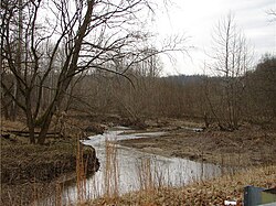 Offield Creek in Balhinch | |
 Balhinch Location in Montgomery County | |
| Coordinates: 39°59′40″N86°59′14″W / 39.99444°N 86.98722°W | |
| Country | United States |
| State | Indiana |
| County | Montgomery |
| Township | Union |
| Settled | February 1821 |
| Area | |
• Total | 2 sq mi (5 km2) |
| Elevation | 620 ft (190 m) |
| Time zone | UTC-5 (Eastern (EST)) |
| • Summer (DST) | UTC-4 (EDT) |
| ZIP Code | 47933 |
| Area code | 765 |
Balhinch is two-mile-square unincorporated community in Union Township, Montgomery County, in the U.S. state of Indiana. Balhinch includes Rattlesnake Canyon and Weir Cemetery.


