
Montgomery County is a county in the U.S. state of Indiana. As of the 2020 United States census, it had a population of 37,936. Its county seat is Crawfordsville. The county is divided into eleven townships which provide local services.

Indiana County is a county in the Commonwealth of Pennsylvania. It is located in the west central part of Pennsylvania. As of the 2020 census, the population was 83,246. Its county seat is Indiana. Indiana County comprises the Indiana, PA Micropolitan Statistical Area, which is also included in the Pittsburgh-New Castle-Weirton, PA-WV-OH Combined Statistical Area.

Elm Springs is a city in Benton and Washington Counties, Arkansas, United States. Located immediately west of Springdale in the Northwest Arkansas metropolitan statistical area, Elm Springs has been gaining population in recent years, including a 47% increase in population between the 2000 and 2010 censuses.

Plainfield is a town in Guilford, Liberty, and Washington townships, Hendricks County, Indiana, United States. The population was 27,631 at the 2010 census, and in 2022 the estimated population was 36,074.

Alamo is a town in Ripley Township, Montgomery County, in the U.S. state of Indiana. The population was 66 at the 2020 census, unchanged from 2010.
Crawfordsville is a city in Montgomery County in west central Indiana, United States, 49 miles (79 km) west by northwest of Indianapolis. As of the 2020 census, the city had a population of 16,306. The city is the county seat of Montgomery County, the only chartered city and the largest populated place in the county. It is the principal city of the Crawfordsville, IN Micropolitan Statistical Area, which encompasses all of Montgomery County. The city is also part of the Indianapolis–Carmel–Muncie, IN Combined Statistical Area.

Darlington is a town in Franklin Township, Montgomery County, in the U.S. state of Indiana. The population was 711 at the 2020 census, down from 843 in 2010.

Ladoga is a town in Clark Township, Montgomery County, in the U.S. state of Indiana. The population was 1,081 at the 2020 census, up from 985 in 2010.
New Richmond is a town in Coal Creek Township, Montgomery County, in the U.S. state of Indiana. The population was 309 at the 2020 census.
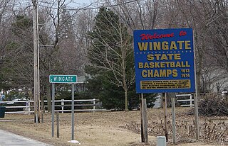
Wingate, formerly known as "Pleasant Hill", is a town in Coal Creek Township, Montgomery County, in the U.S. state of Indiana. The population was 237 at the 2020 census.

Elmdale is a city in Chase County, Kansas, United States. As of the 2020 census, the population of the city was 40. It is located along U.S. Route 50 highway.

Groveland is a town in Essex County, Massachusetts, United States. It is thirty-four miles north of Boston. At the 2020 census, it had a population of 6,752. The town is divided into two precincts, Groveland and South Groveland.

Owasso is a city in Rogers and Tulsa Counties in the U.S. state of Oklahoma, and the largest northern suburb of Tulsa. The population was 39,328 persons as of the 2022 census estimate, compared to 28,915 at the 2010 census, a gain of 36 percent. Originally settled in 1881 in Indian Territory, the town was incorporated in 1904 just before Oklahoma statehood and was chartered as a city in 1972.

Kennebunk is a town in York County, Maine, United States. The population was 11,536 at the 2020 census. Kennebunk is home to several beaches, the Rachel Carson National Wildlife Refuge, the 1799 Kennebunk Inn, many historic shipbuilders' homes, the Brick Store Museum and the Nature Conservancy Kennebunk Plains, with 1,500 acres (6 km2) of nature trails and blueberry fields.

Coal Creek Township is one of eleven townships in Montgomery County, Indiana, United States. As of the 2010 census, its population was 1,544 and it contained 655 housing units.

Montgomery Township is the largest of the ten townships in Gibson County, Indiana as well as one of the largest townships by area in Southwestern Indiana, USA. At the 2010 census, its population was 3,996 and it contained 1,645 housing units, 75% of which were in areas adjacent to Owensville. Montgomery Township is served by the South Gibson School Corporation. Gibson Generating Station and Gibson Lake are located at the northern end of Montgomery Township.

Wayne Township is one of twelve townships in Jay County, Indiana, United States. As of the 2010 census, its population was 7,918 and it contained 3,748 housing units.
Mace is an unincorporated community and census-designated place (CDP) in Walnut Township, Montgomery County, in the U.S. state of Indiana.
Cherry Grove, formerly Cherry Grove Station, is an unincorporated community in Madison Township, Montgomery County, in the U.S. state of Indiana.
Wellington Village is a neighbourhood in Kitchissippi Ward in the west end of Ottawa, Ontario, Canada. It is bounded on the north by Scott Street, on the west by Island Park Drive, on the south by The Queensway and on the east by Holland Avenue. The neighbourhood is covered by the Wellington Village Community Association, with the exception of Island Park Drive, which is covered by the Island Park Community Association. The neighbourhood was originally named Elmdale for the number of elm trees in the area, and was founded in 1922. The homes were built between the 1920s and 1940s.

