Linnsburg, Indiana

Last updated

Linnsburg, Indiana
Linnsburg-indiana.jpg
Location map of Montgomery County, Indiana.svg
Red pog.svg
Linnsburg
Location in Montgomery County
Coordinates: 40°00′01″N86°47′50″W / 40.00028°N 86.79722°W / 40.00028; -86.79722
Country United States
State Indiana
County Montgomery
Township Walnut
Area
[1]
  Total
0.38 sq mi (1.0 km2)
  Land0.38 sq mi (1.0 km2)
  Water0.0 sq mi (0 km2)
Elevation
[2]
843 ft (257 m)
Time zone UTC-5 (Eastern (EST))
  Summer (DST) UTC-4 (EDT)
ZIP code
Area code 765
GNIS feature ID2830468 [2]
FIPS code 18-44172

Linnsburg is a small unincorporated community and census-designated place (CDP) in Walnut Township, Montgomery County, in the U.S. state of Indiana. [2] The town is a former whistle stop on the Monon branch and still has active rail service today from Nucor Steel to Avon.

Contents

History

Linnsburg was platted by Susan McMullen in 1870. [3] A post office was established at Linnsburg in 1887, and remained in operation until 1934. [4]

In the early hours of May 13, 1995, an F-2 tornado struck this small community and killed two people as they slept in their beds. There was no warning. The storm damaged portions of Nucor Steel, Walnut Township Elementary School, and several homes and farms. Police officers and fire fighters from all around the county converged on the scene and spent hours digging through the rubble for survivors. [5] [6] This was part of a series of tornadoes that struck the Midwest.

Geography

Buildings in Linnsburg Linnsburg-sky.jpg
Buildings in Linnsburg

Linnsburg is located in eastern Montgomery County just south of Mace. It is 6 miles (10 km) southeast of Crawfordsville, the county seat, and 39 miles (63 km) northwest of downtown Indianapolis.

According to the U.S. Census Bureau, the Linnsburg CDP has an area of 0.38 square miles (0.98 km2), all land. [1]

Demographics

The United States Census Bureau delineated Linnsburg as a census designated place in the 2022 American Community Survey. [7]

Related Research Articles

<span class="mw-page-title-main">Northridge, Montgomery County, Ohio</span> Unincorporated community and Census-designated place in Ohio, United States

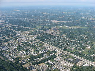
Northridge is an unincorporated community in Harrison Township in Montgomery County, Ohio, United States. It was delineated as a census-designated place (CDP) for the 2000 census, at which time its population was 8,487. It is located directly north of the city of Dayton and is part of the Dayton Metropolitan Statistical Area.

<span class="mw-page-title-main">Riegelwood, North Carolina</span> Census-designated place in North Carolina, United States

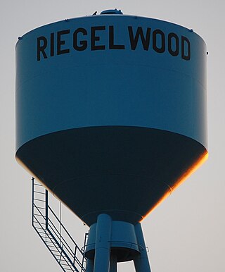
Riegelwood is an unincorporated community and census-designated place (CDP) which sprawls across three counties: Brunswick County, North Carolina; Pender County, North Carolina; Columbus County, North Carolina, United States. As of the 2010 census it had a population of 579. It is the location of a saw mill and a paper mill.

<span class="mw-page-title-main">Harlan, Indiana</span> Census-designated place in Indiana, United States

Harlan is an unincorporated census-designated place (CDP) in Springfield Township, Allen County, in the U.S. state of Indiana. As of the 2010 census, Harlan had a population of 1,634.

<span class="mw-page-title-main">Walnut Township, Montgomery County, Indiana</span> Township in Indiana, United States

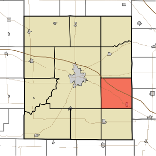
Walnut Township is one of eleven townships in Montgomery County, Indiana, United States. As of the 2020 census, its population was 1,303 and it contained 568 housing units.

Fishersburg is an unincorporated community and census-designated place (CDP) in Stony Creek Township, Madison County, Indiana, United States.

<span class="mw-page-title-main">Dubois, Indiana</span> Census-designated place in Indiana, United States

Dubois is an unincorporated town and census-designated place (CDP) in Dubois County, Indiana, United States. Its population at the 2010 census was 488.

Centerton is an unincorporated community and census-designated place (CDP) in Clay Township, Morgan County, in the U.S. state of Indiana.

<span class="mw-page-title-main">Owensburg, Indiana</span> Census-designated place in Indiana, United States

Owensburg is an unincorporated community and census-designated place (CDP) in Jackson Township, Greene County, Indiana, United States. It was named in honor of the Owens family of early settlers. As of the 2010 census it had a population of 406.

<span class="mw-page-title-main">Scotland, Indiana</span> Census-designated place in Indiana, United States

Scotland is an unincorporated community and census-designated place (CDP) in Taylor Township, Greene County, Indiana, United States. As of the 2010 census it had a population of 134.

<span class="mw-page-title-main">Depauw, Indiana</span> Unincorporated community in Indiana, United States

Depauw is an unincorporated community in Blue River Township and Spencer Township, Harrison County, Indiana. The population of Depauw is officially unknown but is estimated to be 120 as of 2020 and is slowly decreasing.

Kent is an unincorporated community and census-designated place (CDP) in Republican Township, Jefferson County, Indiana, United States. As of the 2010 census it had a population of 70.

<span class="mw-page-title-main">Hanna, Indiana</span> Census-designated place in Indiana, United States

Hanna is an unincorporated community and census-designated place in Hanna Township, LaPorte County, Indiana, United States. It had a population of 463 at the 2010 census.

Donaldson is an unincorporated community and census-designated place (CDP) in West Township, Marshall County, Indiana, United States.

Chili (Cheye-leye) is an unincorporated community and census-designated place in Richland Township, Miami County, in the U.S. state of Indiana.

Miami is an unincorporated community and census-designated place (CDP) in Deer Creek Township, Miami County, in the U.S. state of Indiana.

North Grove is an unincorporated community and census-designated place (CDP) in Harrison Township, Miami County, in the U.S. state of Indiana.

Mace is an unincorporated community and census-designated place (CDP) in Walnut Township, Montgomery County, in the U.S. state of Indiana.

<span class="mw-page-title-main">Eminence, Indiana</span> Census-designated place in Indiana, United States

Eminence is an unincorporated community and census-designated place (CDP) in Adams Township, Morgan County, in the U.S. state of Indiana.

<span class="mw-page-title-main">Bennetts Switch, Indiana</span> Census-designated place in Indiana, United States

Bennetts Switch is an unincorporated community and census-designated place (CDP) in Deer Creek Township, Miami County, in the U.S. state of Indiana.

<span class="mw-page-title-main">Landess, Indiana</span> Census-designated place in Indiana, United States

Landess is an unincorporated community and census-designated place (CDP) in Washington and Van Buren townships, Grant County, Indiana, in the United States. As of the 2010 census it had a population of 188.

References

  1. 1 2 "2022 U.S. Gazetteer Files: Indiana". United States Census Bureau. Retrieved April 25, 2023.
  2. 1 2 3 U.S. Geological Survey Geographic Names Information System: Linnsburg, Indiana
  3. History of Montgomery County, Indiana: With personal sketches of representative citizens. pg 504
  4. "Montgomery County". Jim Forte Postal History. Retrieved June 15, 2017.
  5. "Montgomery County Tornadoes, 1950–2012". National Weather Service. Retrieved December 28, 2013.
  6. "2 Killed as Tornado Hits Indiana". New York Times. May 16, 1995.
  7. "2022 Geography Changes". United States Census Bureau.