
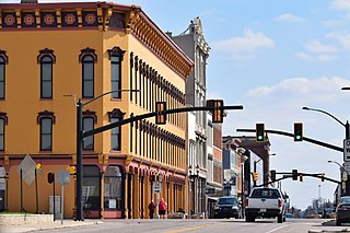
Montgomery County is a county in the U.S. state of Indiana. As of the 2020 United States census, it had a population of 37,936. Its county seat is Crawfordsville. The county is divided into eleven townships which provide local services.

Tippecanoe County is located in the west-central portion of the U.S. state of Indiana about 22 miles east of the Illinois state line and less than 50 miles from the Chicago and the Indianapolis metro areas. As of the 2020 census, the population was 186,251. The county seat and largest city is Lafayette. It was created in 1826 from Wabash County portion of New Purchase and unorganized territory.

Randolph County is a county located in the central section of U.S. state of Indiana, on its eastern border with Ohio. As of 2020, the population was 24,502. The county seat is Winchester.
Muncie is an incorporated city and the seat of Delaware County, Indiana, United States. Previously known as Buckongahelas Town, named after the legendary Delaware Chief, it is located in East Central Indiana, about 50 miles (80 km) northeast of Indianapolis. At the 2020 United States Census, the city's population was 65,195, down from 70,085 in the 2010 Census. It is the principal city of the Muncie Metropolitan Statistical Area, which encompasses all of Delaware County. The city is also included in the Indianapolis–Carmel–Muncie, IN Combined Statistical Area.

Plainfield is a town in Guilford, Liberty, and Washington townships, Hendricks County, Indiana, United States. The population was 27,631 at the 2010 census, and in 2022 the estimated population was 36,074.

Darlington is a town in Franklin Township, Montgomery County, in the U.S. state of Indiana. The population was 711 at the 2020 census, down from 843 in 2010.

Linden is a town in Madison Township, Montgomery County, in the U.S. state of Indiana. The population was 711 at the 2020 census.
New Richmond is a town in Coal Creek Township, Montgomery County, in the U.S. state of Indiana. The population was 309 at the 2020 census.
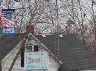
Waynetown is a town in Wayne Township, Montgomery County, in the U.S. state of Indiana. The population was 960 at the 2020 census.
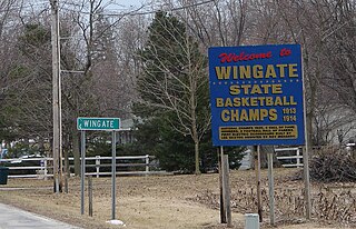
Wingate, formerly known as "Pleasant Hill", is a town in Coal Creek Township, Montgomery County, in the U.S. state of Indiana. The population was 237 at the 2020 census.
Granger is a census-designated place (CDP) in Clay and Harris townships, St. Joseph County, in the U.S. state of Indiana. The population was 30,465 at the 2010 census. Penn-Harris-Madison School Corporation and the South Bend Community School Corporation maintain the public schools in the area. Granger is part of the South Bend–Mishawaka metropolitan area as well as the larger Michiana region.

Garfield Township, officially the Charter Township of Garfield, is a charter township of Grand Traverse County in the U.S. state of Michigan. As of the 2020 census, the township had a total population of 19,499.

Montgomery is a city located in Montgomery County, Texas, United States. As of the 2020 census, the city had a total population of 1,948.

Notre Dame is a census-designated place and unincorporated community north of the city of South Bend in St. Joseph County, in the U.S. state of Indiana. It includes the campuses of three colleges: the University of Notre Dame, Saint Mary's College, and Holy Cross College. Notre Dame is split between Clay and Portage Townships. As of the 2020 census, its population was 7,234.

Derwood is an unincorporated area and census-designated place in east-central Montgomery County, Maryland, United States. It lies just north of Rockville, southeast of Gaithersburg, southwest of Olney, and northwest of the greater Silver Spring area. Derwood was originally "Deer Park" and was then "Deer Wood" before getting its current name.
Porter is an unincorporated community in Montgomery County in Southeastern Texas, United States, within the Houston–The Woodlands–Sugar Land metropolitan area. In 2010, its population was estimated at 25,769. Porter is north of the Kingwood area of Houston.

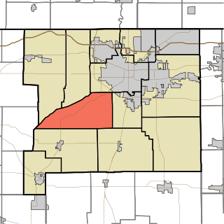
Union Township is one of eleven townships in Montgomery County, Indiana, United States. As of the 2010 census, its population was 24,587 and it contained 10,723 housing units. Wabash College is located in Crawfordsville in this township.
Greene Township is one of thirteen townships in St. Joseph County, in the U.S. state of Indiana. As of the 2000 census, its population was 3,040.
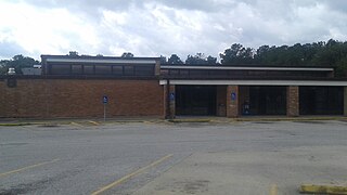
North Montgomery High School is a public high school located in unincorporated Montgomery County, Indiana, near Crawfordsville. It is a part of the North Montgomery School Corporation.
North Montgomery Community School Corporation (NMCSC) or North Montgomery Schools is a school district headquartered in unincorporated Montgomery County, Indiana, north of Crawfordsville. The district serves some sections of northern Crawfordsville, Darlington, Linden, New Richmond, Waynetown, and Wingate. It also serves the unincorporated area of Garfield.

