Ballabeg, Lonan

Last updated

Ballabeg
Manx Electric Railway level crossing.jpg
Isle of Man location map.svg
Red pog.svg
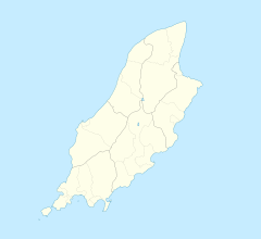
Ballabeg
Location within the Isle of Man
Population<40
OS grid reference SC431822
  Douglas 9 km
Parish Lonan
Sheading Garff
Crown dependency Isle of Man
Post town ISLE OF MAN
Postcode district IM4 7HB
Dialling code 01624
Police Isle of Man
Fire Isle of Man
Ambulance Isle of Man
House of Keys Garff
List of places
Isle of Man
54°12′43″N4°24′22″W / 54.212°N 4.406°W / 54.212; -4.406 Coordinates: 54°12′43″N4°24′22″W / 54.212°N 4.406°W / 54.212; -4.406

There are about eight small places on the Isle of Man with the name Ballabeg. The name Ballabeg derives from the Manx Balley Beg which means small homestead; although the spelling is different, it is pronounced approximately the same as the English name.

This article is about the hamlet of Ballabeg in the parish of Lonan, on the east of the island, overlooking Laxey Bay. The settlement dates from at least 1643, when a Ballabegg was recorded on the Castle Rushen Manorial Roll, under the ownership of Furness Abbey. It is about 300 metres from the sea shore.

Ballabeg in Lonan is located 9 km or nearly 6 miles NE of the capital, Douglas, and 2 km south of the village of Laxey. The hamlet only consists of a farm and a handful of houses, but also is home to the small Ballabeg tram stop which celebrated its centenary in 2005. When the Manx Electric Railway was built through Ballabeg in 1894 an ancient Celtic keeill and adjoining burial ground were discovered. The keeill was known as Keeill Killane (with many spelling variations), shortened to Kilkillane, and gives its name to a nearby stream known as Strooan ny Carlane / Kilane and a house in the hamlet called Kilan. No traces of the keeill survive today. Many lintel graves, buried in triplets, were found at the site. It is believed that the bodies were exhumed and removed, while a large wooden cross and plaque, since removed, marked the site for many years.

A small white cottage, known as the schoolhouse, still stands in Ballabeg next to the site of the former keeill. The building was used as a schoolhouse, religious chapel and social cottage where the locals would gather to play music and tell stories. It is currently being used as a warehouse.

The landscape of Ballabeg is mainly agricultural land used for the grazing of sheep. There are areas of mature and newly planted woodland (including a nationally important cliff-side ancient oak forest remnant), gorse, brooghs (headlands) and small dubs or ponds. The A2 Douglas to Ramsey road bisects the settlement. The Manx Electric Railway runs through the settlement and has a level crossing there. The Raad ny Foillan long-distance path also passes through Ballabeg.

The settlement has no defined boundaries but is said to be bounded by the Raad Ballagawne in the south, the Irish Sea (Laxey Bay) in the east, Church Road in Ballacannel to the north and the old road from Lonan Church to Raad Ballagawne in the west.

In 2018 Laxey Bay was designated as a Marine Nature Reserve. [1]

Related Research Articles

Geography of the Isle of Man

The Isle of Man is an island in the Irish Sea, between Great Britain and Ireland in Western Europe, with a population of almost 85,000. It is a British Crown dependency. It has a small islet, the Calf of Man, to its south. It is located at 54°15′N4°30′W.

Laxey Human settlement in the United Kingdom

Laxey is a village on the east coast of the Isle of Man. Its name derives from the Old Norse Laxa meaning 'Salmon River'. Its key distinguishing features are its three working vintage railways and the largest working waterwheel in the world. It is also the location of King Orry's Grave.

Onchan Human settlement in the United Kingdom

Onchan is a village in the parish of Onchan on the Isle of Man. It is at the north end of Douglas Bay. Administratively a district, it has the second largest population of settlements on the island, after Douglas, with which it forms a conurbation.

Port Erin Human settlement in the United Kingdom

Port Erin is a seaside village in the south-west of the Isle of Man, in the historic parish of Rushen. It was previously a seaside resort before the decline of the tourist trade. Administratively it is designated as a village district, with its own board of commissioners. The district covers around 1 square mile, and is adjacent to: Port St Mary to the south-east; the main part of Rushen parish district to the north and east; the sea to the west; and an exclave of Rushen parish district to the south. Following recent residential expansion, the settlement is now contiguous with that of Port St Mary, and on 18 July 2018 Tynwald authorised a public enquiry into the proposed expansion of the district boundary to include some of this expansion.

Ramsey, Isle of Man Human settlement in the United Kingdom

Ramsey is a coastal town in the north of the Isle of Man. It is the second largest town on the island after Douglas. Its population is 7,845 according to the 2016 census. It has one of the biggest harbours on the island, and has a prominent derelict pier, called the Queen's Pier. It was formerly one of the main points of communication with Scotland. Ramsey has also been a route for several invasions by the Vikings and Scots.

Manx Electric Railway

The Manx Electric Railway is an electric interurban tramway connecting Douglas, Laxey and Ramsey in the Isle of Man. It connects with the Douglas Bay Horse Tramway at its southern terminus at Derby Castle at the northern end of the promenade in Douglas, and with the Snaefell Mountain Railway at Laxey. The line is undulating and passes through areas of scenic beauty. Many visitors take an excursion on the trams.

Snaefell Mountain Railway

The Snaefell Mountain Railway is an electric mountain railway on the Isle of Man in Europe. It joins the village of Laxey with the summit of Snaefell, at 2,036 feet (621 m) above sea level the highest point on the island. It connects with the Manx Electric Railway (MER) in Laxey. The line is 5 miles (8 km) long, is built to 3 ft 6 in gauge and uses a Fell Incline Railway System centre rail for braking on the steep gradients. It is electrified using overhead wires at 550 volts direct current, with bow collectors.

Ballabeg A village in the Isle of Man

Ballabeg is a village on the Isle of Man. It is in the parish of Arbory in the sheading of Rushen, in the south of the island near Castletown. There are several small villages and hamlets with the name, although Ballabeg in Arbory is the most well-known and populous.

Manx National Heritage National heritage organisation of the Isle of Man

Manx National Heritage is the national heritage organisation for the Isle of Man. The organisation manages a significant proportion of the island’s physical heritage assets including over 3,000 acres of coastline and landscape. It holds property, archives, artwork, library and museum collections in trust for the Manx nation. It is the Isle of Man's statutory heritage agency and an Isle of Man registered charity (№ 603).

Garff

Garff is one of the six sheadings of the Isle of Man.

Lonan (parish) Human settlement in the United Kingdom

Lonan is one of the 17 parishes of the Isle of Man.

Creg-ny-Baa, Isle of Man

Creg-ny-Baa is located between the 3rd Milestone and 4th Milestone of the primary A18 Snaefell Mountain Road and the road junction with the secondary B12 'Creg-ny-Baa Back-Road', in the parish of Kirk Onchan in the Isle of Man.

Baldrine railway station

Baldrine Station is a railway halt in the Isle of Man. It is an intermediate request stop on the east coast route of the Manx Electric Railway in the village of Baldrine in the parish of Lonan, on the route to Ramsey.

Raad ny Foillan

Raad ny Foillan is a coastal long distance footpath in the Isle of Man. Because it is a closed loop around the coast, it can be walked in either a clockwise or an anti-clockwise direction.

Ballabeg Station is a rural intermediate request stop on the coastal route of the Manx Electric Railway on the Isle of Man with a small station house constructed in 1905.

Ballagawne Halt is a rural request stop on the Manx Electric Railway on the Isle of Man.

St. Adamnans Church, Lonan

St Adamnan's Church is the former parish church of Lonan in the Isle of Man. The church is situated in an isolated position, surrounded by open farmland on the eastern coast of the island, between Groudle Glen and Baldrine. The eastern part of the church has been restored, but it is otherwise in a ruinous, though well-tended, condition. St Adamnan was the Abbot of Iona between 679 and 704.

Baldrine is a village in the Isle of Man. It is close to the east coast of the island, about 3 km south of Laxey and 6 km NE of Douglas. It is in the historic parish of Lonan, in the sheading of Garff. For administrative purposes it is in the parish district of Garff, and it is also in the House of Keys constituency of Garff.

Laxey Bay is a coastal feature and Marine Nature Reserve on the east coast of the Isle of Man in the north Irish Sea. Geographically it is bounded by Laxey Head to the north and Clay Head to the south.

References