County Dublin is a county in Ireland, and holds its capital city, Dublin. It is located on the island's east coast, within the province of Leinster. Until 1994, County Dublin was a single local government area; in that year, the county council was divided into three new administrative counties: Dún Laoghaire–Rathdown, Fingal and South Dublin. The four areas form a NUTS III statistical region of Ireland. County Dublin remains a single administrative unit for the purposes of the courts, law enforcement and fire services.
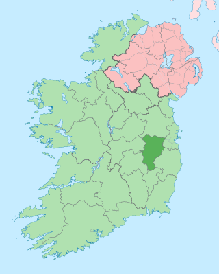
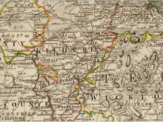
County Kildare is a county in Ireland. It is in the province of Leinster and is part of the Eastern and Midland Region. It is named after the town of Kildare. Kildare County Council is the local authority for the county, which had a population of 246,977 at the 2022 census.

Athy is a market town at the meeting of the River Barrow and the Grand Canal in south-west County Kildare, Ireland, 72 kilometres southwest of Dublin. A population of 9,677 made it the sixth largest town in Kildare and the 50th largest in the Republic of Ireland, with a growth rate of approximately 60 per cent since the 2002 census.
Naas is the county town of County Kildare in Ireland. In 2022, it had a population of 26,180, making it the largest town in County Kildare ahead of Newbridge.
Celbridge is a town and townland on the River Liffey in County Kildare, Ireland. It is 23 km (14 mi) west of Dublin. Both a local centre and a commuter town within the Greater Dublin Area, it is located at the intersection of the R403 and R405 regional roads. As of the 2016 census, Celbridge was the third largest town in County Kildare by population, with over 20,000 residents.

Lucan is a suburban town near Dublin, located 12 km west of the city centre, on the River Liffey. It is near the Strawberry Beds and Lucan Weir, and at the confluence of the River Griffeen. It is mostly under the jurisdiction of South Dublin County Council with the exception of the North Lucan areas of Laraghcon, Coldblow and Saint Catherine's Park, which are in the jurisdiction of Fingal County Council. Road access to Lucan is from the N4, and the M50 motorway at Junction 7.
A townland is a small geographical division of land, historically and currently used in Ireland and in the Western Isles in Scotland, typically covering 100–500 acres (40–202 ha). The townland system is of Gaelic origin, antedating the Norman invasion, and most have names of Irish origin. However, some townland names and boundaries come from Norman manors, plantation divisions, or later creations of the Ordnance Survey. The total number of inhabited townlands in Ireland was 60,679 in 1911. The total number recognised by the Irish Place Names database as of 2014 was 61,098, including uninhabited townlands, mainly small islands.

Ballintra is a village in the parish of Drumholm in the south of County Donegal, Ireland, just off the N15 road between Donegal town and Ballyshannon. Ballintra lies on the northern bank of the Blackwater river. The river rises in the hills that lie inland from the town, and flows through a number of small lakes before spilling over a small waterfall in a gorge behind the village.

Clane is a town in County Kildare, Ireland, 35.4 km (22 mi) from Dublin. Its population of 7,280 makes it the eighth largest town in Kildare and the 66th largest in Ireland. It is on the River Liffey. Clane gives its name to the associated townland, civil parish, electoral division and barony.

Hazelhatch is a townland in South Dublin on the border with County Kildare in Ireland. It is located on the R405 regional road, approximately halfway between Celbridge and Newcastle. The Grand Canal passes through the area, and Hazelhatch is one of the places of recreational activity along the Grand Canal, with fishing and boating. There is one pub in Hazelhatch, beside the canal. Although there is no conventional village centre, there is a concentration of one-off houses in the surrounding area. As of the 2011 census, Hazelhatch townland had a population of 62 people.

Caragh or Carragh is a village in County Kildare, Ireland. It is located on the R409 regional road between the River Liffey and the Grand Canal and is located 6.1 km north-west of Naas. The village is also 7.9 km from Clane and 10.6 km from Newbridge.

Newtownmountkennedy is a small town in County Wicklow, Ireland. It developed within the historic townland of Ballygarny, although all that remains is a motte where a church, graveyard and a castle or tower house once stood just 0.85 km (0.53 mi) north of the town. It acquired its present name in the mid-seventeenth-century, when Sir Robert Kennedy, M.P. for Kildare, made it his principal residence. It is just off the N11 road to Wexford, just south of Kilpedder and south-west of Greystones. It is about 15 km (9.3 mi) north of Wicklow town, 15 km (9.3 mi) south of Bray and approximately 35 km (22 mi) from Dublin. The R772 regional road passes through the village. This was the main Dublin-Wexford route, the N11, but the village was bypassed by the new N11 dual carriageway in 1990. This town has one of the longest place names in Ireland.

Ballyhale is a village in the south east of Ireland. Located in the south of County Kilkenny, south of the city of Kilkenny and roughly halfway to Waterford city.

Crookstown is a village in the south of County Kildare, Ireland. It lies in the townland of Crookstown Upper on the R448 road where it meets the R415 regional road, about 75 km (47 mi) south of Dublin. It has a few hundred inhabitants, a church, a primary school, a petrol station/rest area on the N9, restaurant and small hotel and some craft shops. It is less than one kilometre from the larger neighbouring village of Ballitore, and Crookstown is treated as part of Ballitore for census purposes.
Brownstown is a village in County Kildare, Ireland, south of The Curragh and east of Kildare Town. It is situated on the road from Athy to Newbridge closed to the village of Cutbush. Spanning the townlands of Brownstown Lower and Brownstown Great, it is located in the historical barony of Offaly East and the civil parish of Carn. As of the 2016 census, the Central Statistics Office recorded Brownstown as having a population of 883 people.

Leixlip is a town in north-east County Kildare, Ireland. Its location on the confluence of the River Liffey and the Rye Water has marked it as a frontier town historically: on the border between the ancient kingdoms of Leinster and Brega, as an outpost of The Pale, and on Kildare's border with County Dublin. Leixlip was also a civil parish in the ancient barony of Salt North.

Donaghcumper Church is a ruined medieval church in Celbridge, Ireland. On the Record of Monuments and Places it bears the code KD011-013.

Saint Margaret's is a civil parish and townland in the historical barony of Coolock in Dublin, Ireland. Rivermeade, a housing estate of 175 homes which is treated as a separate census town, is located between Saint Margaret's and the Ward River. Dublin Airport is also nearby.

Ballincar is a small village and townland in County Sligo, Ireland. The townland is in the civil parish of Drumcliff, and has an area of approximately 1.6 square kilometres (0.62 sq mi). It is a largely linear coastal settlement which overlooks Sligo Bay and lies on the R291 regional road between Sligo town and Rosses Point. As of the 2016 census, the census town of Ballincar had a population of 424 people.