Bann, Germany

Last updated
Bann
Wappen von Bann.png
Location of Bann within Kaiserslautern district
Bann in KL.svgFischbachFrankensteinBannLindenHirschhornRodenbach
Germany adm location map.svg
Red pog.svg
Bann
Rhineland-Palatinate location map.svg
Red pog.svg
Bann
Coordinates: 49°23′28″N07°36′46″E / 49.39111°N 7.61278°E / 49.39111; 7.61278 Coordinates: 49°23′28″N07°36′46″E / 49.39111°N 7.61278°E / 49.39111; 7.61278
Country Germany
State Rhineland-Palatinate
District Kaiserslautern
Municipal assoc. Landstuhl
Government
   Mayor (201924) Stephan Mees [1] (CDU)
Area
  Total12.95 km2 (5.00 sq mi)
Elevation
362 m (1,188 ft)
Population
 (2021-12-31) [2]
  Total2,208
  Density170/km2 (440/sq mi)
Time zone UTC+01:00 (CET)
  Summer (DST) UTC+02:00 (CEST)
Postal codes
66851
Dialling codes 06371
Vehicle registration KL

Bann is a municipality in the district of Kaiserslautern, in Rhineland-Palatinate, western Germany. Located in the Steinalb valley with the Palatinate Forest bordering it to the east.

Contents

Vicinity

It is located between the hills of Hausberg (474 m), Kahlenberg (464 m) and Kirchberg (423 m) in the Steinalb valley, which separates the Sickingen Heights from the Palatinate Forest.

Through Bann flows a small stream, the Queidersbach, popularly called Steinalb. It rises at the Ziegelsteige on the Sickingerhöhe.

History

Bann was first mentioned in the year 1182 in a document by the Pope.

Until the end of the 18th century the municipality belonged to the so-called Grand Court of the rule Landstuhl, which was owned by the barons of Sickingen the line to Hohenburg.

In 1794, the left bank of the Rhine was occupied in the War of the First Coalition. From 1978 to 1814 Bann belonged to the canton Landstuhl in the department Donnersberg.

Due to the agreements made at the Congress of Vienna, the area first came to Austria in June 1815 and was ceded to the Kingdom of Bavaria in 1816 on the basis of the Treaty of Munich. Under the Bavarian administration Bann belonged from 1817 to the District of Homburg in the Rhine district, from 1862 to the district office Homburg, moved in 1929 to the district office Kaiserslautern and belongs since 1939 to the district of Kaiserslautern.

In 1982, the 800th anniversary of the municipality was celebrated with a big celebration. Amongst other things there was a big historical procession. [3]

Coat of arms

The coat of arms is held in red and black. On the left hand side it shows a lion on a red background and on the right hand side five silver balls on a black background. The lion stands for the former belonging to the county of Homburg (Saar), while the five balls recall to the administration of the Sickingens for many centuries.

Population growth

The development of the population of the municipality Bann, the values from 1871 to 1987 are based on censuses. [4] [5]

YearPopulationYearPopulation
181541519611.902
183561119702.142
187163619872.180
190588219972.349
19391.36820052.355
19501.62020172.230

Sports

At the season of 2006/2007 the chess club SC Bann took part in the 1.Schachbundesliga (the highest reachable league of chess in Germany).

Famous citizens

Related Research Articles

Kaiserslautern is a district (Kreis) in the south of Rhineland-Palatinate, Germany. Neighboring districts are Kusel, Saarpfalz-Kreis, Donnersbergkreis, Bad Dürkheim and Südwestpfalz. The city of Kaiserslautern is almost fully enclosed by, but not belonging to the district.

<span class="mw-page-title-main">Weilerbach</span> Municipality in Rhineland-Palatinate, Germany

Weilerbach is a municipality in the district of Kaiserslautern, in Rhineland-Palatinate, Germany. It is situated approximately 11 km north-west of Kaiserslautern.

<span class="mw-page-title-main">Landstuhl</span> Town in Germany

Landstuhl is a town in the Kaiserslautern district of Rhineland-Palatinate in Germany. It is the seat of Verbandsgemeinde Landstuhl, a kind of municipal association. Landstuhl is situated on the north-west edge of the Palatinate Forest, 11 miles (18 km) west of Kaiserslautern.

<span class="mw-page-title-main">Hochspeyer</span> Municipality in Rhineland-Palatinate, Germany

Hochspeyer is a municipality in the district of Kaiserslautern, in Rhineland-Palatinate, Germany. It is situated in the Palatinate forest, approx. 10 km east of Kaiserslautern.

<span class="mw-page-title-main">Schallodenbach</span> Municipality in Rhineland-Palatinate, Germany

Schallodenbach is municipality in the district Kaiserslautern of Rhineland-Palatinate, Germany.

<span class="mw-page-title-main">Spessart, Rhineland-Palatinate</span> Municipality in Rhineland-Palatinate, Germany

Spessart is a municipality in the district of Ahrweiler, in Rhineland-Palatinate, Germany.

<span class="mw-page-title-main">Winterbach, Bad Kreuznach</span> Municipality in Rhineland-Palatinate, Germany

Winterbach is a municipality in the district of Bad Kreuznach in Rhineland-Palatinate, in western Germany. It belongs to the Rüdesheim association. Winterbach is also a state-approved resort.

<span class="mw-page-title-main">Sienhachenbach</span> Municipality in Rhineland-Palatinate, Germany

Sienhachenbach is an Ortsgemeinde – a municipality belonging to a Verbandsgemeinde, a kind of collective municipality – in the Birkenfeld district in Rhineland-Palatinate, Germany. It belongs to the Verbandsgemeinde Herrstein-Rhaunen, whose seat is in Herrstein.

<span class="mw-page-title-main">Queidersbach</span> Municipality in Rhineland-Palatinate, Germany

Queidersbach is a municipality in the district of Kaiserslautern, in Rhineland-Palatinate, western Germany.

<span class="mw-page-title-main">Schopp</span> Municipality in Rhineland-Palatinate, Germany

Schopp is a municipality in the district of Kaiserslautern, in Rhineland-Palatinate, western Germany. Schopp station lies on the Biebermühl Railway.

<span class="mw-page-title-main">Linden, Kaiserslautern</span> Municipality in Rhineland-Palatinate, Germany

Linden is a municipality in the district of Kaiserslautern, in Rhineland-Palatinate, western Germany.

<span class="mw-page-title-main">Rodenbach, Rhineland-Palatinate</span> Municipality in Rhineland-Palatinate, Germany

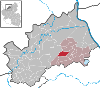
Rodenbach is a municipality in the district of Kaiserslautern, in Rhineland-Palatinate, Germany. It belongs to the Verbandsgemeinde Weilerbach.

Verbandsgemeinde Landstuhl is a Verbandsgemeinde in the district of Kaiserslautern, in Rhineland-Palatinate, western Germany. The seat is in the town of Landstuhl.

<span class="mw-page-title-main">Bechhofen, Rhineland-Palatinate</span> Municipality in Rhineland-Palatinate, Germany

Bechhofen is a municipality in Südwestpfalz district, in Rhineland-Palatinate, western Germany. It is part of the Verbandsgemeinde Zweibrücken-Land.

<span class="mw-page-title-main">Hermersberg</span> Municipality in Rhineland-Palatinate, Germany

Hermersberg is a municipality in Südwestpfalz district, in Rhineland-Palatinate, western Germany and belongs to the municipal association Waldfischbach-Burgalben. It is situated on the western edge of the Palatinate Forest, approx. 15 km northeast of Pirmasens, on top of the Sickingen Heights, and biggest settlement on top.

<span class="mw-page-title-main">Merzalben</span> Municipality in Rhineland-Palatinate, Germany

Merzalben is a municipality in Südwestpfalz district, in Rhineland-Palatinate, western Germany, deriving its name from the Merzalbe, also known as the Merzalb, that flows through the village. Along with 5 other Ortsgemeinden Merzalben belongs to the Verbandsgemeinde Rodalben in Südwestpfalz, wherein it is the largest in terms of physical area, but the smallest in terms of population. The municipality contains several distinct natural and cultural landmarks, with the earliest known records dating back to 1237. It was also considered a state-approved tourist resort before the title was dropped in Rhineland Palatinate in 2016 and all communities awarded the designation were barred from its use in 2020.

<span class="mw-page-title-main">Wiesbach, Germany</span> Municipality in Rhineland-Palatinate, Germany

Wiesbach is a municipality in Südwestpfalz district, in Rhineland-Palatinate, in the southwest of Germany. The place name is composed of the two German words for meadow and brook.

<span class="mw-page-title-main">Palatine Ways of St. James</span> Camino de Santiago pilgrimage routes starting in Germany

The Palatine Ways of St. James are those sections of the Way of St. James in the Palatinate region of Germany and part of the historic pilgrimage route to the northwest Spanish town of Santiago de Compostela. It was there that, according to Christian tradition, the Apostle Saint James the Greater was buried.

<span class="mw-page-title-main">Sickingen Heights</span>

The Sickingen Heights form a landscape in the western part of the German state of Rhineland-Palatinate. The region was named after the family of imperial knight, Franz von Sickingen (1481–1523), because most of the area belonged to the territory of the House of Sickingen in the Middle Ages.

<span class="mw-page-title-main">House of Sickingen</span> Nobel house of the Holy Roman Empire

The House of Sickingen is an old southwest German noble family. The lords of Sickingen belonged to the Kraichgau nobility and from 1797 to the Imperial nobility. Significant relatives emerged from the family, who achieved great influence in both spiritual and secular offices. Reinhard von Sickingen was Prince-Bishop of Worms from 1445 to 1482 and Kasimir Anton von Sickingen was Prince-Bishop of Constance from 1743 to 1750. Imperial Knight Franz von Sickingen (1481-1523) was leader of the Rhenish and Swabian knighthood.

References

  1. Direktwahlen 2019, Landkreis Kaiserslautern, Landeswahlleiter Rheinland-Pfalz, accessed 9 August 2021.
  2. "Bevölkerungsstand 2021, Kreise, Gemeinden, Verbandsgemeinden" (in German). Statistisches Landesamt Rheinland-Pfalz. 2022.
  3. "Geschichte - Bann / Pfalz". www.bann.de. Retrieved 2019-05-23.
  4. Rheinland-Pfalz, Staatskanzlei. "Bevölkerung". Statistisches Landesamt Rheinland-Pfalz (in German). Retrieved 2019-05-23.
  5. Rheinland-Pfalz, Staatskanzlei. "Mein Dorf, meine Stadt (Template)". Statistisches Landesamt Rheinland-Pfalz (in German). Retrieved 2019-05-23.