Barabinsky District

Last updated • 1 min readFrom Wikipedia, The Free Encyclopedia
Barabinsky District
Барабинский район
Sartlan2.jpg
Lake Sartlan, Barabinsky District
Flag of Barabinsky rayon (Novosibirsk oblast).png
Gerb Barabinsk.gif
Barabinsky District
Location of Barabinsky District in Novosibirsk Oblast
Coordinates: 55°21′N78°21′E / 55.350°N 78.350°E / 55.350; 78.350
CountryRussia
Federal subject Novosibirsk Oblast [1]
Established1925 OOjs UI icon edit-ltr-progressive.svg
Administrative center Barabinsk [1]
Area
[2]
  Total5,400 km2 (2,100 sq mi)
Population
  Total14,169
  Density2.6/km2 (6.8/sq mi)
   Urban
0%
   Rural
100%
Administrative structure
   Inhabited localities [1] 51 rural localities
Municipal structure
   Municipally incorporated asBarabinsky Municipal District [4]
   Municipal divisions [4] 1 urban settlements, 11 rural settlements
Time zone UTC+7 (MSK+4   OOjs UI icon edit-ltr-progressive.svg [5] )
OKTMO ID50604000
Website https://admbaraba.nso.ru/

Barabinsky District (Russian : Бара́бинский райо́н) is an administrative [1] and municipal [4] district (raion), one of the thirty in Novosibirsk Oblast, Russia. [2] Its administrative center is the town of Barabinsk (which is not administratively a part of the district). [6] Population: 14,169 (2010 Census); [3] 17,126(2002 Census); [7] 18,279(1989 Soviet census). [8]

Contents

Geography

The district is located in the western central part of the oblast. The area of the district is 5,400 square kilometers (2,100 sq mi). Lakes Chany, Sartlan and Tandovo lie in the district. [9] [10]

Administrative and municipal status

Within the framework of administrative divisions, Barabinsky District is one of the thirty in the oblast. [1] The town of Barabinsk serves as its administrative center, [1] despite being incorporated separately as an administrative unit with the status equal to that of the districts. [6]

As a municipal division, the district is incorporated as Barabinsky Municipal District, with the Town of Barabinsk being incorporated within it as Barabinsk Urban Settlement. [4]

Related Research Articles

<span class="mw-page-title-main">Barabinsk</span> Town in Novosibirsk Oblast, Russia

Barabinsk is a town in Novosibirsk Oblast, Russia, located in the Baraba steppe on the Trans-Siberian Railway between Omsk and Novosibirsk. Population: 30,394 (2010 Census); 32,501 (2002 Census); 36,501 (1989 Soviet census).

<span class="mw-page-title-main">Kuybyshev, Novosibirsk Oblast</span> Town in Novosibirsk Oblast, Russia

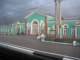
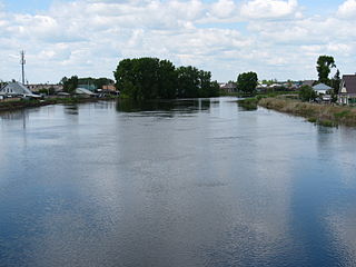
Kuybyshev is a town in Novosibirsk Oblast, Russia, located on the Om River, 315 kilometers (196 mi) west of Novosibirsk, the administrative center of the oblast. Population: 45,299 (2010 Census); 48,848 (2002 Census); 51,171 (1989 Soviet census); 40,000 (1970).

<span class="mw-page-title-main">Kargat</span> Town in Novosibirsk Oblast, Russia

Kargat is a town and the administrative center of Kargatsky District in Novosibirsk Oblast, Russia, located on the river Kargat. Population: 10,042 (2010 Census); 11,184 (2002 Census); 12,561 (1989 Soviet census); 12,600 (1979); 12,700 (1959).

<span class="mw-page-title-main">Toguchin</span> Town in Novosibirsk Oblast, Russia

Toguchin is a town and the administrative center of Toguchinsky District in Novosibirsk Oblast, Russia, located on the Inya River 125 kilometers (78 mi) east of Novosibirsk, the administrative center of the oblast. Population: 21,900 (2010 Census); 22,179 (2002 Census); 23,189 (1989 Soviet census).

<span class="mw-page-title-main">Bolotnoye</span> Town in Novosibirsk Oblast, Russia

Bolotnoye is a town and the administrative center of Bolotninsky District in Novosibirsk Oblast, Russia, located 126 kilometers (78 mi) northeast of Novosibirsk, the administrative center of the oblast. Population: 16,570 (2010 Census); 18,170 (2002 Census); 20,006 (1989 Soviet census).

<span class="mw-page-title-main">Chulym, Chulymsky District, Novosibirsk Oblast</span> Town in Novosibirsk Oblast, Russia

Chulym is a town and the administrative center of Chulymsky District in Novosibirsk Oblast, Russia, located on the Chulym River 131 kilometers (81 mi) from Novosibirsk, the administrative center of the oblast. Population: 11,568 (2010 Census); 12,275 (2002 Census); 13,703 (1989 Soviet census). It was previously known as Chulymskoye.

<span class="mw-page-title-main">Karasuk, Novosibirsk Oblast</span> Town in Novosibirsk Oblast, Russia

Karasuk is a town and the administrative center of Karasuksky District in Novosibirsk Oblast, Russia, located on the Karasuk River 678 kilometers (421 mi) west of Novosibirsk, the administrative center of the oblast. Population: 28,586 (2010 Census); 28,734 (2002 Census); 29,401 (1989 Soviet census).

<span class="mw-page-title-main">Bagansky District</span> District in Novosibirsk Oblast, Russia

Bagansky District is an administrative and municipal district (raion), one of the thirty in Novosibirsk Oblast, Russia. It is located in the southwest of the oblast. The area of the district is 3,367.73 square kilometers (1,300.29 sq mi). Its administrative center is the rural locality of Bagan. Population: 16,627 ; 18,457 (2002 Census); 18,922 (1989 Soviet census). The population of Bagan accounts for 33.1% of the district's total population.

<span class="mw-page-title-main">Chulymsky District</span> District in Novosibirsk Oblast, Russia

Chulymsky District is an administrative and municipal district (raion), one of the thirty in Novosibirsk Oblast, Russia. It is located in the center of the oblast. The area of the district is 8,500 square kilometers (3,300 sq mi). Its administrative center is the town of Chulym. Population: 23,909 ; 26,763 (2002 Census); 31,854 (1989 Soviet census). The population of Chulym accounts for 48.4% of the district's total population.

<span class="mw-page-title-main">Iskitimsky District</span> District in Novosibirsk Oblast, Russia

Iskitimsky District is an administrative and municipal district (raion), one of the thirty in Novosibirsk Oblast, Russia. It is located in the east of the oblast. The area of the district is 4,384 square kilometers (1,693 sq mi). Its administrative center is the town of Iskitim. Population: 62,816 ; 66,420 (2002 Census); 67,733 (1989 Soviet census).

Kochkovsky District is an administrative and municipal district (raion), one of the thirty in Novosibirsk Oblast, Russia. It is located in the south of the oblast. The area of the district is 2,518 square kilometers (972 sq mi). Its administrative center is the rural locality of Kochki. Population: 14,863 ; 16,301 (2002 Census); 16,745 (1989 Soviet census). The population of Kochki accounts for 27.3% of the district's total population.

<span class="mw-page-title-main">Kupinsky District</span> District in Novosibirsk Oblast, Russia

Kupinsky District is an administrative and municipal district (raion), one of the thirty in Novosibirsk Oblast, Russia. It is located in the southwest of the oblast. The area of the district is 5,809 square kilometers (2,243 sq mi). Its administrative center is the town of Kupino. Population: 31,199 ; 37,451 (2002 Census); 40,440 (1989 Soviet census). The population of Kupino accounts for 47.7% of the district's total population.

<span class="mw-page-title-main">Kuybyshevsky District, Novosibirsk Oblast</span> District in Novosibirsk Oblast, Russia

Kuybyshevsky District is an administrative and municipal district (raion), one of the thirty in Novosibirsk Oblast, Russia. It is located in the center of the oblast. The area of the district is 8,823.3 square kilometers (3,406.7 sq mi). Its administrative center is the town of Kuybyshev. Population: 15,466 ; 19,386 (2002 Census); 21,758 (1989 Soviet census).

<span class="mw-page-title-main">Kyshtovsky District</span> District in Novosibirsk Oblast, Russia

Kyshtovsky District is an administrative and municipal district (raion), one of the thirty in Novosibirsk Oblast, Russia. It is located in the northwest of the oblast. The area of the district is 11,101 square kilometers (4,286 sq mi). Its administrative center is the rural locality of Kyshtovka. Population: 12,399 ; 16,427 (2002 Census); 19,081 (1989 Soviet census). The population of Kyshtovka accounts for 42.6% of the district's total population.

<span class="mw-page-title-main">Novosibirsky District</span> District in Novosibirsk Oblast, Russia

Novosibirsky District is an administrative and municipal district (raion), one of the thirty in Novosibirsk Oblast, Russia. It is located in the east of the oblast. The area of the district is 2,900 square kilometers (1,100 sq mi). Its administrative center is the city of Novosibirsk. Population: 127,891 ; 113,047 (2002 Census); 130,300 (1989 Soviet census).

<span class="mw-page-title-main">Ordynsky District</span> District in Novosibirsk Oblast, Russia

Ordynsky District is an administrative and municipal district (raion), one of the thirty in Novosibirsk Oblast, Russia. It is located in the southeast of the oblast. The area of the district is 4,748 square kilometers (1,833 sq mi). Its administrative center is the urban locality of Ordynskoye. Population: 36,708 ; 39,209 (2002 Census); 38,231 (1989 Soviet census). The population of Ordynskoye accounts for 27.9% of the district's total population.

<span class="mw-page-title-main">Severny District, Novosibirsk Oblast</span> District in Novosibirsk Oblast, Russia

Severny District is an administrative and municipal district (raion), one of the thirty in Novosibirsk Oblast, Russia. It is located in the northwest of the oblast. The area of the district is 15,548 square kilometers (6,003 sq mi). Its administrative center is the rural locality of Severnoye. Population: 10,687 ; 11,835 (2002 Census); 12,923 (1989 Soviet census). The population of Severnoye accounts for 49.7% of the district's total population.

<span class="mw-page-title-main">Tatarsky District</span> District in Novosibirsk Oblast, Russia

Tatarsky District is an administrative and municipal district (raion), one of the thirty in Novosibirsk Oblast, Russia. It is located in the west of the oblast. The area of the district is 4,870 square kilometers (1,880 sq mi). Its administrative center is the town of Tatarsk. Population: 15,875 ; 19,297 (2002 Census); 20,718 (1989 Soviet census).

<span class="mw-page-title-main">Toguchinsky District</span> District in Novosibirsk Oblast, Russia

Toguchinsky District is an administrative and municipal district (raion), one of the thirty in Novosibirsk Oblast, Russia. It is located in the east of the oblast. The area of the district is 3,925 square kilometers (1,515 sq mi). Its administrative center is the town of Toguchin. Population: 60,303 ; 65,515 (2002 Census); 66,912 (1989 Soviet census). The population of Toguchin accounts for 36.3% of the district's total population.

<span class="mw-page-title-main">Tatarsk, Novosibirsk Oblast</span> Town in Novosibirsk Oblast, Russia

Tatarsk is a town in Novosibirsk Oblast, Russia, located 457 kilometers (284 mi) west of Novosibirsk, the administrative center of the oblast. Population: 24,217 (2010 Census); 26,051 (2002 Census); 30,355 (1989 Soviet census); 31,000 (1974).

References

Notes

  1. 1 2 3 4 5 6 Государственный комитет Российской Федерации по статистике. Комитет Российской Федерации по стандартизации, метрологии и сертификации. №ОК 019-95 1 января 1997 г. «Общероссийский классификатор объектов административно-территориального деления. Код 50 204», в ред. изменения №278/2015 от 1 января 2016 г.. (State Statistics Committee of the Russian Federation. Committee of the Russian Federation on Standardization, Metrology, and Certification. #OK 019-95 January 1, 1997 Russian Classification of Objects of Administrative Division (OKATO). Code 50 204 , as amended by the Amendment #278/2015 of January 1, 2016. ).
  2. 1 2 "General Information" (in Russian). Barabinsky District. Retrieved April 12, 2018.
  3. 1 2 Russian Federal State Statistics Service (2011). Всероссийская перепись населения 2010 года. Том 1 [2010 All-Russian Population Census, vol. 1]. Всероссийская перепись населения 2010 года [2010 All-Russia Population Census] (in Russian). Federal State Statistics Service.
  4. 1 2 3 4 Law #200-OZ
  5. "Об исчислении времени". Официальный интернет-портал правовой информации (in Russian). June 3, 2011. Retrieved January 19, 2019.
  6. 1 2 Государственный комитет Российской Федерации по статистике. Комитет Российской Федерации по стандартизации, метрологии и сертификации. №ОК 019-95 1 января 1997 г. «Общероссийский классификатор объектов административно-территориального деления. Код 50 405», в ред. изменения №278/2015 от 1 января 2016 г.. (State Statistics Committee of the Russian Federation. Committee of the Russian Federation on Standardization, Metrology, and Certification. #OK 019-95 January 1, 1997 Russian Classification of Objects of Administrative Division (OKATO). Code 50 405 , as amended by the Amendment #278/2015 of January 1, 2016. ).
  7. Federal State Statistics Service (May 21, 2004). Численность населения России, субъектов Российской Федерации в составе федеральных округов, районов, городских поселений, сельских населённых пунктов – районных центров и сельских населённых пунктов с населением 3 тысячи и более человек [Population of Russia, Its Federal Districts, Federal Subjects, Districts, Urban Localities, Rural Localities—Administrative Centers, and Rural Localities with Population of Over 3,000](XLS). Всероссийская перепись населения 2002 года [All-Russia Population Census of 2002] (in Russian).
  8. Всесоюзная перепись населения 1989 г. Численность наличного населения союзных и автономных республик, автономных областей и округов, краёв, областей, районов, городских поселений и сёл-райцентров [All Union Population Census of 1989: Present Population of Union and Autonomous Republics, Autonomous Oblasts and Okrugs, Krais, Oblasts, Districts, Urban Settlements, and Villages Serving as District Administrative Centers]. Всесоюзная перепись населения 1989 года [All-Union Population Census of 1989] (in Russian). Институт демографии Национального исследовательского университета: Высшая школа экономики [Institute of Demography at the National Research University: Higher School of Economics]. 1989 via Demoscope Weekly.
  9. "N-44 Topographic Chart (in Russian)" . Retrieved July 22, 2022.
  10. "N-43 Topographic Chart (in Russian)" . Retrieved July 22, 2022.

Sources