
Gorakhpur is a city in the Indian state of Uttar Pradesh, along the banks of the Rapti river in the Purvanchal region. It is situated 272 kilometres east of the state capital, Lucknow. It is the administrative headquarters of Gorakhpur district, North Eastern Railway Zone and Gorakhpur division. The city is home to the Gorakhnath Math, a Gorakhnath temple. The city also has had an Indian Air Force station since 1963. Gita Press, the world's largest publisher of Hindu religious texts like Ramayana and Mahabharat, has been established here since 1926.

Bettiah is a city and the administrative headquarters of West Champaran district - (Tirhut). It is near the Indo-Nepal border, 225 kilometres (140 mi) northwest of Patna, in the state of Bihar, India.
Maharajganj district is one of the 75 districts of Uttar Pradesh state in northern India, and the town of Maharajganj is the district headquarters. District is a part Gorakhpur division. It is located in Terai region of Himalayas, bordering Nepal in North. Gandak, Rapti, Rohin are some major river flowing through the district.

Asika or Aska (ଆସିକା)/(ଆସ୍କା) is a town and a Municipality in Ganjam district in the state of Odisha, India. Famously known as the Sugar city.
Banmankhi Bazar is a town and a notified area in Purnia district in the state of Bihar, India.
Chirgaon is a town and a municipal board in Jhansi district in the Indian state of Uttar Pradesh, India.
Digapahandi is a town and a Notified Area Council (N.A.C.) in Ganjam district in the state of Odisha, India. There are 171 small villages which comes under Digapahandi tahasil and largely dependent on this town for their business and livelihood. Digapahandi town is divided into 11 wards, comprising Bazar street, Sunari street, New street, Phulasundari Street, Balaji Nagar Bada Brahmin street, Sana Brahmin street, Sasan street, Chikitia street, Rani street, Annapurna street, Anchala street, Uparabasa, Chikiti road.
Pharenda, or Anandnagar, is a city in the Maharajganj district of the province of Uttar Pradesh in northern India. It is located approximately 44 kilometres north of Gorakhpur near the border with Nepal. District of Pharenda is Maharajganj. This is situated on the Buddhist Circuit which is built from Sarnath to Lumbini. It lies on NH-24 and near NH 29. It is about 45 km from Gorakhpur, 40 km from Siddharthnagar, 30 km from Maharajganj and 55 km from Sonauli Indo-Nepal border. This place is named after Seth Anandram Jaypuriya. There is closed sugar Mill which was started in about 1935 and closed in 1995. Near Anand Nagar there is a temple is Durga devi mandir, popularly known as Lehara Devi mandir.
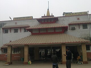
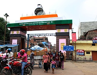
Raxaul is a sub-divisional town in the East Champaran district of the Indian state of Bihar. It is situated at the India-Nepal border with Birgunj city (Nepal). Raxaul is a major railway junction.
Degana is a town municipality and headquarter to Sub-Division and Tehsil located in Nagaur district of Rajasthan, India.
Gola Bazar is a town and a nagar panchayat in Gorakhpur district in the Indian state of Uttar Pradesh. It is also known for its gold market. It is located near the Saryu (Ghaghra) river. This river itself is a border between Gorakhpur and Azamgarh. Distance from Gorakhpur City is around 54 km via kauriram. It is one of the tehsils of Gorakhpur. It is very famous for its ghats which are on the bank of river Saryu. Gola market is very famous among the villages and other towns around it.
Kudra, formerly known as Jahanabad, is a town and corresponding community development block in Kaimur district in the state of Bihar, India. It is the third largest town in Kaimur district. It is situated about 18 km from District Headquarter Bhabua. As of 2011, the population of Kudra was 30986. The railway station in Kudra is connected to all major railway routes.
Warwat Bakal is a Gram Panchayat, in Sangrampur tehsil of Buldhana district, includes in Vidarbha region in the state of Maharashtra, India.

Harchandpur is a village and corresponding community development block in Raebareli district, Uttar Pradesh, India. It is located on the Baiti river, which is a tributary of the Sai, and it is northeast from the district headquarters on the road to Lucknow. Particularly since the coming of the railway in the 1800s, Harchandpur serves as one of the main commercial centres for the surrounding region; it is also a major exporter of local goods. As of 2011, its population is 4,348 people, in 833 households.
Campierganj also called as Chaumukha, is a small Town in the province of Uttar Pradesh in north India, approximately 34 km (21 mi) north of Gorakhpur city near the border with Nepal on National Highway-24 (NH-24) in Gorakhpur District. This is situated on the Buddhist Circuit which is built from Lumbini (Nepal), Kushinagar, Sarnath up to Bodh Gaya. Campierganj is a Tahsil (subdivision) in Gorakhpur district of Uttar Pradesh.
Patherwa is a small village in Kushinagar district, previously Deoria district, Uttar Pradesh, India located near Fazilnagar. The place Kushinagar is known for Lord Budhha Mahaparinirvan sthali.

Ayodhya Junction railway station, officially named as Ayodhya Dham Junction railway station, is a railway station in the city of Ayodhya in the state of Uttar Pradesh, India. It is located at Dharmakata, 1.5 km (0.93 mi) south-west from the city centre and 1.2 km (0.75 mi) south-east from Ram Mandir. It is one of two railway junction stations in the city; the other one is Faizabad Junction. The station falls under the Northern Railway zone of the Indian Railways. The station's code is "AY".
Manik Chowk is a village in the Indian state of Bihar.
Nimbi Jodha is a town in Ladnu, Nagaur District, Rajasthan, India. It belongs to Ajmer Division. It is located 75 km east of the district headquarters, Nagaur, and 51 km from Salasar Balaji.

The Gorakhpur Metrolite is a light rapid transit system proposed for the city of Gorakhpur, Uttar Pradesh, India. The network will consist of 2 elevated lines serving 27 stations with a total length of 27.41 kilometres. The project is estimated to cost ₹4,672 crore (US$590 million). It is expected to be completed by 2024.

