
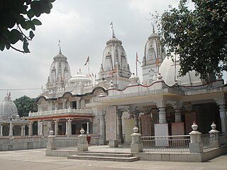
Gorakhpur is a city in the Indian state of Uttar Pradesh, along the banks of the Rapti river in the Purvanchal region. It is situated 272 kilometres east of the state capital, Lucknow. It is the administrative headquarters of Gorakhpur district, North Eastern Railway Zone and Gorakhpur division. The city is home to the Gorakhnath Math, a Gorakhnath temple. The city also has had an Indian Air Force station since 1963. Gita Press, the world's largest publisher of Hindu religious texts like Ramayana and Mahabharata, has been established here since 1926.

Jaunpur is a city and a municipal board in Jaunpur district in the Indian state of Uttar Pradesh. It is located 228 km southeast of state capital Lucknow. Demographically, Jaunpur resembles the rest of the Purvanchal area in which it is located.

Sultanpur is a city situated in the Indian state of Uttar Pradesh on the banks of the Gomti, which Hindus consider a holy river. The city is the administrative headquarters of Sultanpur district and is a part of Ayodhya division in Uttar Pradesh, India. It is situated 135 kilometers east of state capital Lucknow.

Azamgarh district is one of the three districts of Azamgarh division in the Indian state of Uttar Pradesh.

Ambedkar Nagar is one of the 75 districts of the Indian state of Uttar Pradesh. This district is a part of Ayodhya division in the Awadh region of the state. This district was established on 29 September 1995 by carving out parts of the erstwhile Faizabad district. It was created by the then Chief Minister Mayawati and named in memory of B. R. Ambedkar, who worked for the advancement of the depressed classes. The total area of Ambedkar Nagar district is 2350 Sq. Km.
Gorakhpur district is one of the 75 districts of Uttar Pradesh state in northern India. This district is a part of the Gorakhpur division. The city of Gorakhpur, or Gorakhpur is the administrative headquarters of this district and Gorakhpur division. It borders Sant Kabir Nagar district to the west, Kushinagar and Deoria districts to the east, and Maharajganj and Azamgarh districts to the north and south.
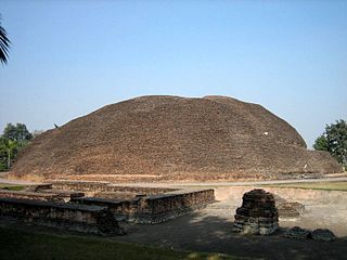
Kushinagar is a district of the state of Uttar Pradesh in India situated in the easternmost part of the state. It has the administrative headquarters at Ravindra Nagar Dhoos. The district is named such after the town Kushinagar, a Buddhist pilgrimage site where Gautama Buddha attained parinirvana in the 5th century BCE. Since the independence of India, Kushinagar district was a part of Deoria District and came into existence on 13 May 1994 as a separate district division. It was earlier known as Padrauna and thereafter was renamed Kushinagar on 19 June 1997.
Bansi is a city and municipal board situated on a bank of the Rapti River in the Siddharthnagar district in the state of Uttar Pradesh, India. It is one of the five vidhan sabha constituencies in Siddharthnagar district and one of the most important cities of the district. The Indo Nepal border is near to the town around 40 km. Lumbini of Nepal is the best place to visit from Bansi by crossing the open border between Nepal and India. The Magh Mela is a fair which is held for a month in Bansi from 25 January to 25 February, attracting visitors from all the surrounding areas.
Bilariaganj is the second largest city and a nagar palika parishad in Azamgarh division after its capital city Azamgarh in the state of Uttar Pradesh, India.

Chakeri is a census town in Kanpur metropolitan area, situated about 16 kilometres east of Kanpur city in the state of Uttar Pradesh, India. It is an industrial town with textiles and food products as its major productions. Chakeri Airforce Station, North India's second-largest air force base is situated here. Chakeri is home to reputed educational institutions and colleges. Central Leather Research Institute, the only government leather research institute in North India is situated here. The Grand Trunk Road made by emperor Sher Shah Suri passes through Chakeri. The town is enlisted as a town area of the Kanpur metropolitan area.
Khadda is a town, a nagar panchayat and a tehsil in Kushinagar district in the Indian state of Uttar Pradesh. It is situated approximately 8 kilometres (5.0 mi) from the border with Bihar and 18 kilometres (11 mi) from the India-Nepal border.
GIDA Sahjanwan is industrial area of Gorakhpur in the state of Uttar Pradesh. It is fast developing an industrial area abbreviated as GIDA with many factories, including IGL, Parle and ARP, as well as power looms, plywood and the only jute mill in Uttar Pradesh.
Tanda is a town in Ambedkar Nagar district in the Indian state of Uttar Pradesh situated on the banks of Ghaghara River. It is a nagar palika parishad and is part of Ayodhya division in Uttar Pradesh. The town is situated 20 kilometres (12 mi) north east from district headquarter Akbarpur. Tanda is also a tehsil in the district. It has one of the largest handloom weaving industries for manufacturing varieties like gamchha, lungi, polyester clothing, check-shirt clothes material in state of Uttar Pradesh.
Gola Bazar is a town and a nagar panchayat in Gorakhpur district in the Indian state of Uttar Pradesh. It is also known for its gold market. It is located near the Saryu (Ghaghra) river. This river itself is a border between Gorakhpur and Azamgarh. Distance from Gorakhpur City is around 54 km via kauriram. It is one of the tehsils of Gorakhpur. It is very famous for its ghats which are on the bank of river Saryu. Gola market is very famous among the villages and other towns around it.
Usraon (Mariyahu) is a town and nagar panchayat in Jaunpur district in the Indian state of Uttar Pradesh. It is one of the six tahsils of Jaunpur District; the others are Jaunpur City, Shahganj, Machalishahar, Badlapur and Kerakat.

Baramadpur is a village in Akhand Nagar block of Kadipur tehsil in Sultanpur district of Uttar Pradesh, India. As of 2011, it has a population of 3,251 people, in 442 households. It has one primary school and one primary health centre and it hosts both a regular market and a weekly haat. It is part of the nyaya panchayat of Sajampur.
Rajesultanpur or Raje Sultanpur is a town and nagar panchayat in Ambedkar Nagar district in the Indian state of Uttar Pradesh.

Saifai is a large village and university town in the Etawah district of the Indian state of Uttar Pradesh. It is also a sub-division (Tehsil) and Block of the Etawah district. It is the birthplace of Mulayam Singh Yadav, the founding president of the Samajwadi Party, former Minister of Defence in India, and former Chief Minister of Uttar Pradesh.
Bhadon is a village and Gram Panchayat located in Martinganj tehsil of the Azamgarh District in the Indian state of Uttar Pradesh, near the border with Jaunpur District. It is 37.7 kilometres (23.4 mi) north-east of the district headquarters in Azamgarh and 229.9 kilometres (142.9 mi) from the state capital of Lucknow.
Madaria is a village in Gola Block and Tehsil (sub-district) of Gorakhpur district in the Indian State of Uttar Pradesh. The total geographical area of village is 75.21 hectares. The village has 247 households. The village has its Gram Panchayat and Post Office. The native language is Hindi. Madaria is located 61.1 km from Gorakhpur and 7 km from sub-district headquarters Gola Bazar.

