
Gorakhpur is a city in the Indian state of Uttar Pradesh, along the banks of the Rapti river in the Purvanchal region. It is situated 272 kilometres east of the state capital, Lucknow. It is the administrative headquarters of Gorakhpur district, North Eastern Railway Zone and Gorakhpur division. The city is home to the Gorakhnath Math, a Gorakhnath temple. The city also has had an Indian Air Force station since 1963. Gita Press, the world's largest publisher of Hindu religious texts like Ramayana and Mahabharat, is also located in Gorakhpur and was established there in 1926.

Aalo, formerly Along, is a census town and headquarter of the West Siang district district of the Indian state of Arunachal Pradesh. It is located 137 kilometres (85 mi) from Likabali, which is at the border of Assam and Arunachal Pradesh.
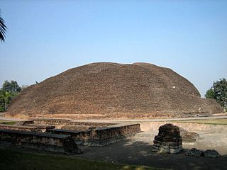
Kushinagar is a district of the state of Uttar Pradesh in India situated in the easternmost part of the state. It has the administrative headquarters at Ravindra Nagar Dhoos. The district is named such after the town Kushinagar, a Buddhist pilgrimage site where Gautama Buddha attained parinirvana in the 5th century BCE. Since the independence of India, Kushinagar district was a part of Deoria District and came into existence on 13 May 1994 as a separate district division. It was earlier known as Padrauna and thereafter was renamed Kushinagar on 19 June 1997.
Jalandhar Cantonment is a cantonment town in Jalandhar District in the Indian state of Punjab. The Cantonment is located between latitude 30° 18' and longitude 75° 37' on the southwest and at a distance of 2 km from Cantonment Railway Station and 5 km from City Railway Station. It is situated beside Grand Trunk Road at a distance of 89 km from Amritsar and 371 km from Delhi. It covers an area of 5.87 square miles (15.2 km²). It is on Amritsar-Delhi Broad Gauge Main Line. A Class-I airfield at Adampur is situated at a distance of 19 km. The airfield is linked with Jalandhar Cantonment by rail and road. It has a Recruiting Office responsible for enlisting the soldiers for Army, Navy and Air Force. The first Recruiting Officer who held this post until 1952 was Col. Dilbagh Singh Minhas of Jallandhar Doab.
Bagaha is a city and a municipality in the district of Pashchim Champaran in the state of Bihar, India. It is a subdivision of Pashchim Champaran district and is a Police District. It is located around 64 kilometres (40 mi) northwest of its district headquarters Bettiah. It is 294 km (183 mi) away from Bihar's state capital Patna.
Bhatpar Rani is a town and tehsil in Deoria District in the state of Uttar Pradesh in India. It belongs to Gorakhpur Division. It is located 48 km towards East from District headquarters Deoria.The Member of Legislative Council of Bhatpar Rani Constituency is Shri. Sabhakunwar Kushwaha In Bhatpar Rani, the block number of village is 127. The biggest village in this tehsil is Sarayan. Khan Sir(Teacher), Shilpi Raj(Singer) were born here.
Chanpatia is a city in Nagar Panchayat situated on the bank of the Burhi Gandak River. It is the administrative headquarters of the Chanpatia block in Paschim Champaran district near the Indo-Nepal border; 18 km from District headquarters Bettiah, 242 km north-west of the capital Patna in the state of Bihar, India. Chanpatia is well-known for its cuisine, such as Marcha Ka chura, Basmati rice, and Handi kabab.
Nautanwa is a town and Nagar Palika in Maharajganj district in the state of Uttar Pradesh, India. It is about 87 km from Gorakhpur, NH24 and 68 km NH730 from Maharajganj and 7 km from Sonauli Indo-Nepal Border.
Pharenda, or Anandnagar, is a city in the Maharajganj district of the province of Uttar Pradesh in northern India. It is located approximately 44 kilometres north of Gorakhpur near the border with Nepal. District of Pharenda is Maharajganj. This is situated on the Buddhist Circuit which is built from Sarnath to Lumbini. It lies on NH-24 and near NH 29. It is about 45 km from Gorakhpur, 40 km from Siddharthnagar, 30 km from Maharajganj and 55 km from Sonauli Indo-Nepal border. This place is named after Seth Anandram Jaypuriya. There is closed sugar Mill which was started in about 1935 and closed in 1995. Near Anand Nagar there is a temple is Durga devi mandir, popularly known as Lehara Devi mandir.
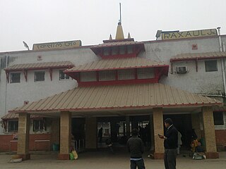
Raxaul is a sub-divisional town in the East Champaran district of the Indian state of Bihar. It is situated at the India-Nepal border with Birgunj city (Nepal). Raxaul is a major railway junction.
Kanti is a town and a notified area in Muzaffarpur district in the Indian state of Bihar. It is also a block headquarters belongs to "Tirhut Division". It is located 15 km by road from District headquarters Muzaffarpur. Kanti holds a distinct history for it was a spot for indigo production. Kanti was once a site for saltpeter production. In 2022, Kanti Nagar Panchayat was upgraded to Nagar Parishad. Pin Code 843109.
Khadda is a town, a nagar panchayat and a tehsil in Kushinagar district in the Indian state of Uttar Pradesh. It is situated approximately 8 kilometres (5.0 mi) from the border with Bihar and 18 kilometres (11 mi) from the India-Nepal border.
Lauthaha is a city and a notified area in Purvi Champaran district in the Indian state of Bihar.
Nichlaul is a town and a nagar panchayat in Maharajganj district in the Indian state of Uttar Pradesh. It is situated 25 km from district headquarter Maharajganj and 80 km from Gorakhpur. It is situated near the Indo-Nepal border.
Pipraich is a town and a nagar panchayat in Gorakhpur district in the Indian state of Uttar Pradesh. The Pipraich block comes under the tehsil Sadar. It was declared a town on 25 November 1871, under the Bengal Chaukidari Act, of 1856 and is now administered as a town area under the U.P. Town Areas Act of 1914.
GIDA Sahjanwan is industrial area of Gorakhpur in the state of Uttar Pradesh. It is fast developing an industrial area abbreviated as GIDA with many factories, including IGL, Parle and ARP, as well as power looms, plywood and the only jute mill in Uttar Pradesh.

Kasba is a satellite town of Purnia city and part of Purnia Urban Agglomeration in Purnia district in the Indian state of Mithila region of Bihar.
Sumerpur, also known as Bharuwa Sumerpur, is a town and a nagar panchayat in Hamirpur district, Uttar Pradesh, India.
Badlapur is an administrative division in Jaunpur District in the Indian state of Uttar Pradesh. It was accorded the status of Town Area Nagar Panchayat on 27 June 2014.
Rithuakhor is a village and gram panchayat in Sahjanwa tehsil in Gorakhpur district in the Indian state of Uttar Pradesh.This village belongs to majority of janwar kshatriya caste.
