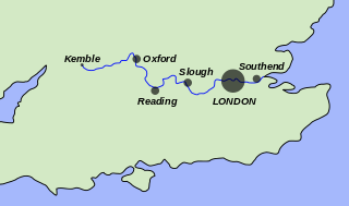
The River Thames, known alternatively in parts as the River Isis, is a river that flows through southern England including London. At 215 miles (346 km), it is the longest river entirely in England and the second-longest in the United Kingdom, after the River Severn.
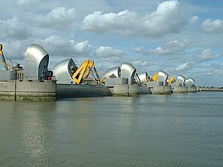
The Thames Barrier is a retractable barrier system built to protect the floodplain of most of Greater London from exceptionally high tides and storm surges moving up from the North Sea. It has been operational since 1982. When needed, it is closed (raised) during high tide; at low tide, it can be opened to restore the river's flow towards the sea. Built about 2 miles east of the Isle of Dogs, its northern bank is in Silvertown in the London Borough of Newham and its southern bank is in the New Charlton area of the Royal Borough of Greenwich.

A weir or low-head dam is a barrier across the width of a river that alters the flow characteristics of water and usually results in a change in the height of the river level. Weirs are also used to control the flow of water for outlets of lakes, ponds, and reservoirs. There are many weir designs, but commonly water flows freely over the top of the weir crest before cascading down to a lower level. There is no single definition as to what constitutes a weir, and one English dictionary simply defines a weir as a small dam.

Barking is a riverside town in East London, England, within the London Borough of Barking and Dagenham. It is 9.3 miles (15 km) east of Charing Cross, bordered by Ilford to the North, Dagenham to the East and East Ham, London to the West. The total population of Barking was 59,068 at the 2011 census. In addition to an extensive and fairly low-density residential area, the town centre forms a large retail and commercial district, currently a focus for regeneration. The former industrial lands to the south are being redeveloped as Barking Riverside.
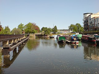
The River Lea is in the East of England and Greater London. It originates in Bedfordshire, in the Chiltern Hills, and flows southeast through Hertfordshire, along the Essex border and into Greater London, to meet the River Thames at Bow Creek. It is one of the largest rivers in London and the easternmost major tributary of the Thames.

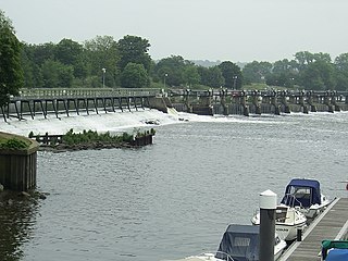
The English River Thames is navigable from Cricklade or Lechlade to the sea, and this part of the river falls 71 meters (234 feet). There are 45 locks on the river, each with one or more adjacent weirs. These lock and weir combinations are used for controlling the flow of water down the river, most notably when there is a risk of flooding, and provide for navigation above the tideway.

The Jubilee River is a hydraulic channel in southern England. It is 11.6 km (7.2 mi) long and is on average 45 metres wide. It was constructed in the late 1990s and early 2000s to take overflow from the River Thames and so alleviate flooding to areas in and around the towns of Maidenhead, Windsor, and Eton in the counties of Berkshire and Buckinghamshire. It achieves this by taking water from the left bank of the Thames upstream of Boulter's Lock near Maidenhead and returning it via the north bank downstream of Eton. Although successful in its stated aims, residents of villages downstream, such as Wraysbury, claim it has increased flooding in those locations.
Richmond Lock and Footbridge is a lock, rising and falling low-tide barrage integrating controlled sluices and pair of pedestrian bridges on the River Thames in southwest London, England, and is a Grade II* listed structure. It is the furthest downstream of the forty-five Thames locks and the only one owned and operated by the Port of London Authority. It was opened in 1894 and is north-west of the centre of Richmond in a semi-urban part of southwest London. Downstream are Syon Park and Kew Gardens on opposite banks. It connects the promenade at Richmond with the neighbouring district of St. Margarets on the west bank during the day and is closed at night to pedestrians – after 19:30 GMT or after 21:30 when BST is in use. At high tide the sluice gates are raised and partly hidden behind metal arches forming twin footbridges.

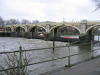
Teddington Lock is a complex of three locks and a weir on the River Thames between Ham and Teddington in the London Borough of Richmond upon Thames, England. Historically in Middlesex, it was first built in 1810.

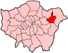
The Thames Estuary is where the River Thames meets the waters of the North Sea, in the south-east of Great Britain.

The River Roding rises at Molehill Green, Essex, England, then flows south through Essex and London and forms Barking Creek as it reaches the River Thames.

The 1953 North Sea flood was a major flood caused by a heavy storm surge that struck the Netherlands, north-west Belgium, England and Scotland. Most sea defences facing the surge were overwhelmed, resulting in extensive flooding.

The Thames Path is a National Trail following the River Thames from one of its sources near Kemble in Gloucestershire to the Woolwich foot tunnel, south east London. It is about 185 miles (298 km) long. A path was first proposed in 1948 but it only opened in 1996.
The Tideway is a part of the River Thames in England which is subject to tides. This stretch of water is downstream from Teddington Lock. The Tideway comprises the upper Thames Estuary including the Pool of London.

Creekmouth is an area of Barking in east London, England. It is best known for its large industrial estate. The industrial area around River Road and Thames Road is one of the London Borough of Barking and Dagenham's largest employment areas. Creekmouth has a wide range of businesses from small local manufacturers to major multi-national companies.
Penton Hook Island is a mainly wooded former peninsula created into a series of three weir-divided islands in the River Thames in England, so created in river modifications since 1815 with a navigable lock and weir stream channel to form meander cutoffs. It has a lock and weirs that are the divide between the Laleham Reach, above Chertsey Lock and Staines Reach, above Penton Hook Lock.

The Maidenhead Waterways are a system of canals in Maidenhead, England. Formerly disused, plans to restore and upgrade them were announced in 2011. The works would initially make the waterways navigable by small craft, and over time by larger craft, as limitations to navigation are gradually removed.
The Abbey River is a right-bank backwater of the River Thames in England, in Chertsey, Surrey — in the town's northern green and blue buffers. The L-shaped conduit adjoins mixed-use flood plain: water-meadows landscaped for a golf course, a motorway and a fresh water treatment works on the island it creates, Laleham Burway to its east and north in turn. Its offtake from the Thames is at the apex of Penton Hook, Staines upon Thames below its lower weir close to the Chertsey-Thorpe boundary in the Borough of Runnymede. Its outfall is the weir pool of Chertsey Lock back into the Thames, visible from Chertsey Bridge.
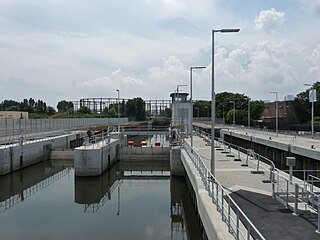
Three Mills Lock, also known as Prescott Lock, is a lock on the Prescott Channel on the River Lea in London. The current structure was constructed by British Waterways and officially opened on 5 June 2009.