Becontree or is an area of approximately 4 square miles (10 km2) in the London Borough of Barking and Dagenham. It is located 11 miles (17.7 km) east-northeast of Charing Cross and was constructed in the interwar period as the largest public housing estate in the world. The Housing Act 1919 permitted the London County Council to build housing outside the County of London and Becontree was constructed between 1921 and 1935 to cottage estate principles in the parishes of Barking, Dagenham and Ilford, then in Essex. The official completion of the estate was celebrated in 1935, by which time the estate had a population of around 100,000 people in 26,000 homes.

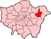
The London Borough of Barking and Dagenham is a London borough in East London. It lies around 9 miles (14.4 km) east of Central London. It is an Outer London borough and the south is within the London Riverside section of the Thames Gateway; an area designated as a national priority for urban regeneration. At the 2011 census it had a population of 187,000, the majority of which are within the Becontree estate. The borough's three main towns are Barking, Chadwell Heath and Dagenham. The local authorities are the Barking and Dagenham London Borough Councils. Barking and Dagenham was one of six London boroughs to host the 2012 Summer Olympics.
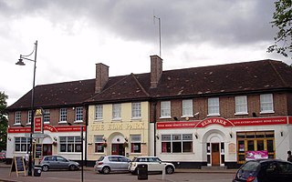
Elm Park is a suburban planned community in East London within the London Borough of Havering. Located 14.3 miles (23.0 km) east-northeast of Charing Cross, it is identified as a district centre in the London Plan with several streets of shops and a priority for regeneration. Prior to the construction of the extensive Elm Park Garden City development in the 1930s it was a scattered settlement of farms in the south of the parish of Hornchurch. Elm Park has been connected to central London by the electrified District line service since 1935 and the planned development of the area formed part of the interwar private housing boom that was interrupted by World War II. After the war Elm Park expanded with social housing and it has formed part of Greater London since 1965.
Dagenham is a town in East London, England, within the London Borough of Barking and Dagenham. Dagenham is centred 11.5 miles (18.5 km) east of Charing Cross.

Barking is a suburb and area in Greater London, within the Borough of Barking and Dagenham. It is 9.3 miles (15 km) east of Charing Cross. The total population of Barking was 59,068 at the 2011 census. In addition to an extensive and fairly low-density residential area, the town centre forms a large retail and commercial district, currently a focus for regeneration. The former industrial lands to the south are being redeveloped as Barking Riverside.

Chadwell Heath is an area in east London, England. It is situated on the boundary of the London Borough of Barking and Dagenham and the London Borough of Redbridge, around 2 miles (3.2 km) west of Romford and 4 miles (6.4 km) east of Ilford, and 12 miles (19 km) north-east of Charing Cross.

Becontree is a London Underground station located to the south of Becontree in the London Borough of Barking and Dagenham, east London. It is on the District line between Upney to the west and Dagenham Heathway to the east. It is 9.1 kilometres (5.7 mi) along the line from the eastern terminus at Upminster and 25.1 kilometres (15.6 mi) to Earl's Court in central London where the line divides into numerous branches. It is in Travelcard Zone 5.

Beckton is a suburban district in East London, England, within the London Borough of Newham and is located 8 miles (12.9 km) east of Charing Cross. Historically part of Essex, Beckton was unpopulated marshland adjacent to the River Thames until the development of major industrial infrastructure in the 19th century to support the growing metropolis of London. Housing was created in Beckton for workers of the gas and sewage works. Between 1981 and 1995 it was within the London Docklands Development Corporation area, which caused the population to increase as new homes were built and the Docklands Light Railway was constructed.

East London refers to the part of London, England, east of the ancient City of London and north of the River Thames. It consists of areas in the historic counties of Essex and Middlesex.

East London Transit (ELT) is a part-segregated bus rapid transit, operated as part of the London Buses network. The East London Transit opened in phases between 2010 and 2013. The scheme for this system was developed by Transport for London to meet the existing and anticipated demand for public transport in East London caused by the Thames Gateway redevelopment, and has been planned to allow for a possible future upgrade to tram operation.

The London Riverside is a redevelopment area on the north side of the River Thames in East London, England and part of the larger Thames Gateway redevelopment zone. The London Riverside area forms part of the Green Enterprise District, a project to create a low-carbon economy region in Greater London. Land available for redevelopment is owned by GLA Land and Property. From 2004 to 2013 the redevelopment of London Riverside and the Lower Lea Valley was the responsibility of the London Thames Gateway Development Corporation. There is also a London Riverside business improvement district which covers a smaller area.
Dagenham was a local government district in south west Essex, England from 1926 to 1965 covering the parish of Dagenham. Initially created as an urban district, it was incorporated as a municipal borough in 1938. It was established to deal with the increase in population and the change from rural to urban area caused by the building of the Becontree estate by the London County Council and the subsequent movement of people from Inner London. Peripheral to London, the district formed part of the Metropolitan Police District and London Traffic Area. It now forms the eastern sections of the London Borough of Barking and Dagenham and the London Borough of Redbridge in Greater London.

Barking Riverside is a mixed-use development in the area of Barking, east London, England, within the London Borough of Barking and Dagenham. It is being built on land formerly occupied by Barking Power Station, adjacent to the River Thames, and is 10.5 miles (16.9km) east of Charing Cross. The 440 acre brownfield site has planning permission for 10,800 homes.

Dagenham Dock is a place in the London Borough of Barking and Dagenham in London, England. It is located to the south of Dagenham and on the River Thames. It was once the site of a large coaling port and continues to be the location of a small terminal licensed to handle coal off-loading. Today the site is used for a number of river-related uses including a 25 acres (100,000 m2) TDG depot with around 200 tanks for storage of petrol, distillates, aviation fuel, biofuels, tallow, ethanol, fertilisers, urea etc.

Creekmouth is an area of Barking in east London, England. It is best known for its large industrial estate. The industrial area around River Road and Thames Road is one of the London Borough of Barking and Dagenham's largest employment areas. Creekmouth has a wide range of businesses from small local manufacturers to major multi-national companies.

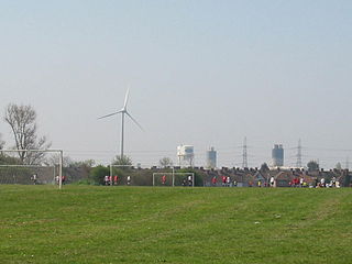
The Dagenham wind turbines are two 85-metre (279 ft) high Enercon E-66 and one E-82 wind turbines located on the Dagenham estate of the Ford Motor Company in East London, England. The first two turbines were completed in April 2004 and the third was installed in 2011. They are landmarks of the skyline and the first wind farm to be built in London.
The Docklands Light Railway extension to Dagenham Dock was a proposed extension of the Docklands Light Railway to Dagenham Dock in East London, to serve the Barking Riverside development and the wider Thames Gateway area.
There are various formal and informal subdivisions of London Borough of Barking and Dagenham and of parts of that borough.

Rainham is a suburb of East London, England, in the London Borough of Havering. Historically an ancient parish in the county of Essex, Rainham is 13.6 miles (21.9 km) east of Charing Cross and is surrounded by a residential area, which has grown from the historic village, to the north and a commercial area, fronting the River Thames, to the south. As part of the suburban growth of London in the 20th century, Rainham significantly expanded and increased in population, becoming part of Hornchurch Urban District in 1934, and has formed part of Greater London since 1965. The economic history of Rainham is underpinned by a shift from agriculture to industry and manufacture and is now in a period of regeneration, coming within the London Riverside section of the Thames Gateway redevelopment area.
The 2022 Barking and Dagenham London Borough Council election took place on 5 May 2022. All 51 members of Barking and Dagenham London Borough Council were elected. The elections took place alongside local elections in the other London boroughs and elections to local authorities across the United Kingdom.