Barking Riverside

Last updated

Barking Riverside
Rivergate Centre, Barking, London.jpg
Rivergate Centre
Greater London UK location map 2.svg
Red pog.svg
Barking Riverside
Location within Greater London
OS grid reference TQ466825
  Charing Cross 10.5 mi (16.9 km)  W
London borough
Ceremonial county Greater London
Region
Country England
Sovereign state United Kingdom
Post town BARKING
Postcode district IG11
Dialling code 020
Police Metropolitan
Fire London
Ambulance London
UK Parliament
London Assembly
List of places
UK
England
London
51°31′22″N0°06′45″E / 51.5228°N 0.1124°E / 51.5228; 0.1124

Barking Riverside is a mixed-use development in the area of Barking, east London, England, within the London Borough of Barking and Dagenham. It is being built on land formerly occupied by Barking Power Station, adjacent to the River Thames, and is 10.5 miles (16.9km) east of Charing Cross. The 440 acre brownfield site has planning permission for 10,800 homes. [1]

Contents

As planning restrictions prevented more than 1,200 homes without adequate transport links, [2] the London Overground Gospel Oak to Barking line has been extended to Barking Riverside to allow the development to be completed as planned [3] and the new station opened on 18 July 2022.

Between 1995 and 2000, Bellway Homes built 900 homes and since 2004 the development has been managed by Barking Riverside Ltd, a partnership between GLA Land and Property and Bellway. Building work under this partnership commenced in 2010 and the first homes were occupied in 2012.

In 2016, housing association L&Q bought out Bellway's stake in Barking Riverside Ltd, entering into a joint venture with the GLA to deliver the remaining new homes. [4] There will be three neighbourhood centres and when complete in the 2030s, the development as a whole will have a population of approximately 26,000. [1]

History

Housing under construction, Fielders Crescent, Barking Riverside Housing under construction, Fielders Crescent, Barking Riverside.jpg
Housing under construction, Fielders Crescent, Barking Riverside

The development is taking place on brownfield land that was formerly occupied by Barking Power Station. Prior to being drained for industrial use, it was tidal marshland. The power station closed in 1981, with a concentration of National Grid pylons, overhead lines, cables and sub stations remaining.

In the early 1990s, the Department of Environment sought brownfield sites in the Thames Gateway area for development. The Barking project started as a public-private venture between the Greater London Authority, English Partnerships and developer Bellway Homes. [3] National Power sold the land to Bellway Homes in 1994. [5] The site has low land value, but the cost of converting it from industrial use caused Bellway to be concerned about profitability. Initially Bellway constructed 900 homes on the site between 1995 and 2000. Barking Riverside Ltd provided essential infrastructure such as roads, utilities and community facilities.

The site is in the London Riverside section of the Thames Gateway and was within the area of the London Thames Gateway Development Corporation (LTGDC), established in 2004.

In 2004 Barking Riverside Ltd was formed as a joint venture of Bellway Homes and the Homes and Communities Agency (later replaced by GLAP) to deliver the project. Outline planning permission was granted in August 2007, with detailed consent for the first phases given in June 2009. [6] Work started in 2010, and the first homes following the establishment of Barking Riverside Ltd were completed and occupied in 2012. [7]

The development corporation was abolished in 2013 and responsibility passed to GLA Land and Property (GLAP), a subsidiary of the Greater London Authority (GLA). The project was jointly managed by the Homes and Communities Agency until its London operations were folded into the GLA in April 2012. [8]

In 2016, L&Q bought Bellway's 51% stake in the scheme. It will deliver the new homes and infrastructure with the existing joint venture partner the GLA. [4]

In 2017, the first three schools - Riverside School - opened in the area, serving primary, secondary and special needs students - all located on one campus on Renwick Road. [9]

Toponymy

Barking is an ancient parish name, found in the Domesday Book of 1086. The appellation 'Barking Riverside' refers to the location adjacent to the River Thames. Initially the name Barking Reach was selected for the area. [5]

Governance

The local authority is Barking and Dagenham London Borough Council. Since 2022, most of the development is within the Barking Riverside ward, which returns three councillors. Some western sections of Barking Riverside are in the Thames View ward, which returns two councillors. For elections to the London Assembly it is part of the City and East constituency. For elections to the UK Parliament it is within the Barking constituency.

As of 2015, the two roads giving access to the development are still privately owned by the developers. [3]

Geography

The 443 acres (1.79 km2) site has planning permission for 10,800 homes and is expected to have a population of approximately 26,000 people. [10] [11] It is located between the A13 road and Barking–Rainham railway line to the north and the River Thames to the south. [12] It has 1.2 miles (1.9 km) of riverside frontage. The intention is to create three neighbourhood centres. To the north is the Thames View Estate and to the west is Creekmouth. To the south of Barking Riverside and over the River Thames is the large housing development of Thamesmead.

Culture and community

The Rivergate Centre, between Minter Road and Handley Page Road, is a community centre that houses halls for hire, the George Carey Primary School, the Rivergate Church and the Riverside School (secondary). [13]

There is also a cafe, a pharmacy, and a beauty salon. The local grocery shop on Minter Road was taken over by Co-Op in 2020, re-opening in July 2020 after a refurbishment. [14]

In phases 2 and 3 of the development, there is a provision for a new Health and Leisure Hub including a large family-friendly swimming pool and 150-station gym. This will also incorporate a GP surgery, leisure centre and various community spaces. [15] [16]

Transport

Barking Riverside station Barking Riverside station, London - 2023-04-29-4.jpg
Barking Riverside station

Bus

Barking Riverside is connected to Barking, Goodmayes, Ilford and Dagenham Dock and other places by the East London Transit bus rapid transit services EL1, EL2 and EL3.

Overground extension

As planning restrictions prevent more than 1,200 new homes being built before adequate transport links are in place, [2] the area was to be served by an extension of the Docklands Light Railway, but this was cancelled in 2008. [17] In 2014, it was announced that the London Overground Gospel Oak to Barking Line would be extended to Barking Riverside to allow the development to be completed as planned. [3] The new station opened on 18 July 2022. [18]

River services

Barking Riverside Pier Barking Riverside Pier - 2023-04-29 3.jpg
Barking Riverside Pier

On 22 April 2022 the river bus company Thames Clippers began serving an existing pier newly added to the London River Services network. Now called Barking Riverside Pier, it is situated on the north bank of the Thames in what will eventually become the district centre, a short distance from the new London Overground station. During the morning and evening peaks, and at weekends, Thames Clippers provides passenger river bus services on the RB1 route to Woolwich Arsenal, Canary Wharf and piers in central London.

Related Research Articles

<span class="mw-page-title-main">London Borough of Barking and Dagenham</span> London borough in United Kingdom

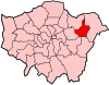
The London Borough of Barking and Dagenham is a London borough in East London. It lies around 9 miles (14.4 km) east of Central London. It is an Outer London borough and the south is within the London Riverside section of the Thames Gateway; an area designated as a national priority for urban regeneration. At the 2011 census it had a population of 187,000, the majority of which are within the Becontree estate. The borough's three main towns are Barking, Chadwell Heath and Dagenham. The local authority is the Barking and Dagenham London Borough Council. Barking and Dagenham was one of six London boroughs to host the 2012 Summer Olympics.

<span class="mw-page-title-main">Dagenham</span> Town in east London, England

Dagenham is a town in East London, England, within the London Borough of Barking and Dagenham. Dagenham is centred 11.5 miles (18.5 km) east of Charing Cross.

<span class="mw-page-title-main">Thames Gateway</span> Area around the Thames Estuary

Thames Gateway is a term applied to an area around the Thames Estuary in the context of discourse around regeneration and further urbanisation. The term was first coined by the UK government and applies to an area of land stretching 70 kilometres (43 mi) east from inner east and south-east London on both sides of the River Thames and the Thames Estuary. It stretches from Westferry in Tower Hamlets to the Isle of Sheppey/Southend-on-Sea and extends across three ceremonial counties.

<span class="mw-page-title-main">Barking, London</span> Human settlement in England

Barking is a town in East London, England, within the London Borough of Barking and Dagenham. It is 9.3 miles (15 km) east of Charing Cross. The total population of Barking was 59,068 at the 2011 census. In addition to an extensive and fairly low-density residential area, the town centre forms a large retail and commercial district, currently a focus for regeneration. The former industrial lands to the south are being redeveloped as Barking Riverside.

<span class="mw-page-title-main">East London Transit</span> Bus rapid transit system in Barking, Goodmayes, Ilford and Dagenham

East London Transit (ELT) is a part-segregated bus rapid transit, operated as part of the London Buses network. The East London Transit opened in phases between 2010 and 2013. The scheme for this system was developed by Transport for London to meet the existing and anticipated demand for public transport in East London caused by the Thames Gateway redevelopment, and has been planned to allow for a possible future upgrade to tram operation.

<span class="mw-page-title-main">London Riverside</span>

The London Riverside is a redevelopment area on the north side of the River Thames in East London, England. The area was identified as a zone of change following the introduction of the Thames Gateway policy in 1995. Proposals for improvements in the area were at first developed by Havering and Barking and Dagenham councils, with a London Riverside Urban Strategy published in 2002. This was incorporated into the first London Plan published by the Mayor of London in 2004. Between 2004 and 2013 the planning powers in London Riverside and the Lower Lea Valley were the responsibility of the London Thames Gateway Development Corporation. Planning powers have now reverted to the local councils. Much of the land available for redevelopment is now owned by GLA Land and Property. There is also a London Riverside business improvement district, which covers a smaller area.

<span class="mw-page-title-main">London Thames Gateway Development Corporation</span>

The London Thames Gateway Development Corporation (LTGDC) was a non-departmental public body sponsored by the Department for Communities and Local Government, with directors appointed by the Secretary of State, including some democratically elected councillors. It was an urban Development Corporation charged with redevelopment of two areas of northeast London, England that are within the Thames Gateway. From October 2005, it took over certain planning functions from the councils of the borough councils in its designated area.

<span class="mw-page-title-main">Dagenham Dock</span> Industrial district in London, England

Dagenham Dock is an industrial district in the London Borough of Barking and Dagenham in London, England. It is located to the south of Dagenham and is on the River Thames. It was once the site of a large coaling port and continues to be the location of a small terminal licensed to handle coal off-loading. Today the site is used for a number of river-related operations including a 25-acre (100,000 m2) TDG depot with around 200 tanks for the storage of petrol, distillates, aviation fuel, biofuels, tallow, ethanol, fertilisers, and urea.

<span class="mw-page-title-main">Beam Park</span> Neighbourhood in London, England

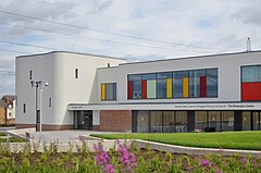
Beam Park is a new neighbourhood in the south of the London Borough of Barking and Dagenham and the London Borough of Havering. It is named after the River Beam which forms the boundary between the boroughs. It is part of the London Riverside opportunity area and is designated with neighbouring Rainham as a housing zone by the Greater London Authority. It covers an area of 29 hectares. It will include a town centre in the Havering part of the development and will be served by Beam Park railway station. Much of the land previously part of the Ford Dagenham site is being redeveloped as a joint venture between London and Quadrant and Countryside Properties. Planning consent for 3,000 homes was issued in February 2019 and construction began in May 2019. The first residents moved into Beam Park in December 2020. Planning permission was given for 947 additional homes in December 2022

There are various formal and informal subdivisions of London Borough of Barking and Dagenham and of parts of that borough.

<span class="mw-page-title-main">Hornchurch Marshes</span> Human settlement in England

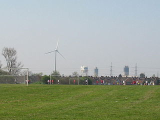
Hornchurch Marshes is an area of the London Borough of Havering, adjacent to the north bank of the River Thames in London, England. Susceptible to flooding from three adjacent rivers, it was the southernmost marshland section of the ancient parish of Hornchurch. It was used for cattle grazing from the 16th to the 19th century and became industrialised by the 20th century. The eastern part of the Ford Dagenham estate extended into the Hornchurch Marshes and it is now an area of regeneration that includes Beam Reach and part of Beam Park. Two of the Dagenham wind turbines are located there and the Centre for Engineering and Manufacturing Excellence.

<span class="mw-page-title-main">Rainham, London</span> Suburb of East London, England

Rainham is a suburb of East London, England, in the London Borough of Havering. Historically an ancient parish in the county of Essex, Rainham is 13.6 miles (21.9 km) east of Charing Cross and is surrounded by a residential area, which has grown from the historic village, to the north and a commercial area, fronting the River Thames, to the south. As part of the suburban growth of London in the 20th century, Rainham significantly expanded and increased in population, becoming part of Hornchurch Urban District in 1934, and has formed part of Greater London since 1965. The economic history of Rainham is underpinned by a shift from agriculture to industry and manufacture and is now in a period of regeneration, coming within the London Riverside section of the Thames Gateway redevelopment area.

Public transport in the London Borough of Havering, in east London, England, is a mix of National Rail, London Underground, London Overground and Elizabeth line and London Buses services. Rail services are primarily radial to central London with bus services providing most of the orbital connections. The public transport authority is Transport for London and the local authority is Havering London Borough Council.

GLA Land and Property (GLAP) is a subsidiary company of the Greater London Authority. It was formed on 1 April 2012 as a replacement for the London Development Agency (LDA) as an arms length corporate body to take on the assets of the LDA and other agencies, under the direction of the Mayor of London. It is one of the largest public sector landowners in London and its primary aims are to create jobs and housing. GLAP is headquartered in Windsor House, Westminster in the offices used by Transport for London.

<span class="mw-page-title-main">Barking Riverside railway station</span> London Overground station

Barking Riverside is a railway station in the London Borough of Barking and Dagenham, East London. The station serves the Barking Riverside regeneration area, and was built as part of a £327m extension of the Gospel Oak to Barking Line to the area. It opened on 18 July 2022. It is served by London Overground, and provides interchange with the Uber Boat by Thames Clippers boat service from Barking Riverside Pier.

The Docklands Light Railway extension to Thamesmead is a proposed Docklands Light Railway (DLR) extension to serve the Beckton Riverside and Thamesmead redevelopment areas of East London.

R25 was a proposed railway orbital around the Zone 3 area of London, England. First proposed in the Mayor of London's £1.3 trillion London Infrastructure 2050 plan, the line would have used some existing Network Rail and London Overground lines, linked by stretches of new railway.

<span class="mw-page-title-main">Castle Green railway station</span> Proposed Railway Station

Castle Green is a proposed railway station in the London Borough of Barking and Dagenham. Plans for a station at the site, initially called Renwick Road, have been in development since at least 2002. The new station was first proposed to be between Barking and Dagenham Dock on the London, Tilbury and Southend line. In 2017 a station was safeguarded on the extension of the Gospel Oak to Barking line between Barking and Barking Riverside. The station would serve the communities of Castle Green, Thames View Estate and new housing developments in the area.

<span class="mw-page-title-main">Barking Riverside Pier</span>

Barking Riverside Pier is an Uber Boat by Thames Clippers commuter service pier located on the River Thames at Barking Riverside. Passenger services began on 26 April 2022. The pier provides interchange with Barking Riverside railway station and local bus routes. The pier was brought into use following a renovation of the reinforced concrete coaling jetty previously used by Barking Power Station.

References

  1. 1 2 "New Build Homes in East London". Barking Riverside. Retrieved 15 April 2020.
  2. 1 2 "Boris Johnson calls for creation of new 'garden suburb' in Barking and Dagenham". Evening Standard. 13 February 2014. Retrieved 15 April 2020.
  3. 1 2 3 4 Tim Burrows (17 August 2015). "No cafe, no pub, no doctor in London's most isolated suburb". The Guardian. Retrieved 17 August 2015.
  4. 1 2 "L&Q buys out Bellway at 11,000-home Barking Riverside".
  5. 1 2 National Audit Office (2007). "The Thames Gateway: Laying the Foundations" (PDF). London: The Stationery Office. pp. 51–54. Archived (PDF) from the original on 17 August 2015. Retrieved 17 August 2015.
  6. "Barking Riverside Ltd: Continuation of Support and Statutory Accounts" (PDF). Greater London Authority. Archived from the original (PDF) on 22 March 2014. Retrieved 12 June 2015.
  7. Barking Riverside | Greater London Authority Archived 20 October 2013 at the Wayback Machine
  8. London | Homes and Communities Agency (HCA) Archived 3 December 2013 at the Wayback Machine
  9. Shaw, Alex (11 September 2017). "Three-in-one free school campus opens in Barking Riverside". Barking and Dagenham Post. Retrieved 15 April 2020.
  10. Our story | Barking Riverside Barking Riverside
  11. Barking Riverside Archived 12 November 2014 at the Wayback Machine
  12. "Archived copy" (PDF). Archived from the original (PDF) on 7 September 2012. Retrieved 2014-03-21.{{cite web}}: CS1 maint: archived copy as title (link)
  13. "Rivergate Centre - Who is at the Centre". Rivergate Centre. Archived from the original on 23 March 2014. Retrieved 23 March 2014.
  14. Brookes, Andrew (3 August 2020). "Hospitals charity receives £2k donation as Co-op Food store at Barking Riverside launched". Barking and Dagenham Post. Retrieved 21 January 2021.
  15. Leigh@spinachbranding. com. "What's coming to Barking Riverside". Barking Riverside. Retrieved 21 January 2021.
  16. "DC/04/01230/OUT Report" (PDF). Retrieved 21 January 2021.
  17. "TfL scraps projects and cuts jobs". BBC News. 6 November 2008. Retrieved 15 April 2020.
  18. "Barking Riverside extension". Archived from the original on 11 August 2016. Retrieved 17 June 2022.