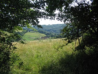
Honeybrook Farm is a working farm three miles (4.8 km) south of Castle Combe in Wiltshire, England, between the villages of Biddestone and Slaughterford. The farm has a total area of sixty-five hectares, of which forty-two point four one hectares are designated as a biological Site of Special Scientific Interest.

North Meadow, Cricklade is a hay meadow near the town of Cricklade, in Wiltshire, England. It is 24.6 hectares in size. It is a traditionally managed lowland hay-meadow, or lammas land, and is grazed in common between 12 August and 12 February each year, and cut for hay no earlier than 1 July. This pattern of land use and management has existed for many centuries and has resulted in the species rich grassland flora and fauna present on the site.

Lambert's Castle is an Iron Age hillfort in the county of Dorset in southwest England. Since 1981 it has been designated as a Site of Special Scientific Interest (SSSI) on account of its geology, archaeology and ecology. The hillfort is designated a scheduled monument together with a bowl barrow, the sites of a post-medieval fair and a telegraph station. The site was on the Heritage at Risk Register but was removed in 2022 as a result of the Hillforts and Habitats Project.
Newton Ketton Meadow is a Site of Special Scientific Interest in the Darlington district of Durham, England. It is situated alongside a small tributary of the River Skerne, about 2 km south-west of the village of Great Stainton and 3 km east of the village of Brafferton.
The Bottoms is a Site of Special Scientific Interest in County Durham, England. It lies just south of the A181 road, roughly midway between the villages of Cassop and Wheatley Hill, some 10 km south-east of Durham city.
Gweunydd Glan-y-glasnant is a Site of Special Scientific Interest (SSSI) in Carmarthenshire, Wales, designated in 1993 for its botanical features.

Allendale Moors is a Site of Special Scientific Interest (SSSI) in Northumberland, England. The upland moorland ridge site is listed for its heath, flush and upland grassland which provide a habitat for a nationally important assemblage of moorland breeding birds.
Allolee to Walltown is the name given to a Site of Special Scientific Interest (SSSI) in Northumberland, England. The site, which follows the path of a section of Hadrian's Wall, is notable for an unusually wide range of grassland types growing on thin soil above the Whin Sill, a rock formation peculiar to the Northern Pennines.

Arcot Hall Grasslands and Ponds is the name given to a Site of Special Scientific Interest (SSSI) near Cramlington in Northumberland, England, notable as the largest lowland species-rich grassland in North East England. The site is composed of grassland, heath, ponds, and associated damp habitats now rare in Northumberland.
Aules Hill Meadows is the name given to a Site of Special Scientific Interest (SSSI) in Northumberland, England. The site, listed since 1992, is a set of four traditionally managed northern hay meadows, now rare in Northumberland.
Barelees Pond is the name given to a Site of Special Scientific Interest (SSSI) in north Northumberland, England. The site is a kettle hole, a deep pond formed in the void remaining after a submerged glacial calf block melted. Barelees Pond is illustrative of vegetative habitat evolution as peat sediment gradually fills the pond.
Barrow Meadow is a Site of Special Scientific Interest (SSSI) in north Northumberland, England. The site is a species-rich hay meadow of a sort now rare in Northumberland.

Bewick and Beanley Moors is the name given to a Site of Special Scientific Interest (SSSI) in north Northumberland, in the north-east of England. The moors are asserted to be of national importance by Natural England for the extent, quality and diversity of upland types including heaths, fens, wet grassland, flushes, mires and blanket bogs, together creating an extensive mosaic habitat supporting an exceptional community of amphibians. The moors are important, too, for their relict juniper woodland and scrub.
Billsmoor Park and Grasslees Wood is the name given to a Site of Special Scientific Interest (SSSI) in Northumberland, North East England, designated in 1954. Billsmoor Park is an extensive alder woodland of a sort increasingly uncommon in the county; the much smaller Grasslees Wood is an oak woodland.
Brada Hill is a small hill escarpment near the coast of north Northumberland in North East England, designated as a Site of Special Scientific Interest (SSSI). The 2.4 hectares site is an outcropping of a local stone group, the Whin Sill, on which grows a range of flora representative of the thin, drought-prone soil conditions and influenced by the underlying geology.
Burnfoot River Shingle and Wydon Nabb is the name given to a Site of Special Scientific Interest (SSSI) in Northumberland, North East England. Burnfoot River Shingle is a calaminarian grassland on the River South Tyne where the local flora is influenced by high levels of naturally occurring heavy metals. Wydon Nabb is an escarpment displaying the Haltwhistle Dyke, a magmatic intrusion of igneous dolerite set amidst sedimentary sandstone and shale.
Fallowlees Flush is the name given to a Site of Special Scientific Interest (SSSI) in mid-Northumberland, England. The steeply sloping site has calcium-rich springs supporting vegetation rare in the county.
Farnham Mires is a Site of Special Scientific Interest, or SSSI, to the west of the village of Farnham, North Yorkshire, England. It consists of a spring-fed marshy fen or mire with reeds and sedge, and drier calcareous grassland containing a diverse range of flora. It has a history of poaching and fox hunting, but since the late 19th century, the attention of botanists has been drawn to its large variety of flowering plants. It has received some consideration on this account since 1944, and from 1954 it was designated SSSI status. This site has no facilities, and is not open to the public.

Bishop Monkton Ings is a Site of Special Scientific Interest, or SSSI, situated east of Bishop Monkton village in North Yorkshire, England. It consists mostly of marshy, calcareous grassland, with some broadleaved woodland, and some fen alongside the two watercourses which run through the site. This varied wetland forms a habitat for a variety of plants, including the semi-parasitic marsh lousewort (Pedicularis palustris).

Mar Field Fen is a Site of Special Scientific Interest, or SSSI, north of Masham, North Yorkshire, England, in a rural area known as Marfield. It is situated on land containing woodland carr, fen, spring-fed marshy grassland and drier calcareous grassland, between the River Ure to the east and Marfield Wetland nature reserve to the west. As "one of the best examples of fen habitat in the Vale of York," it is a protected habitat for a variety of plants, including the common butterwort, a carnivorous plant. There is no public access to this site.
