| Alwinton | |
|---|---|
 St Michael and All Angels | |
 Alwinton Location within Northumberland | |
| Population | 71 (2001 census) [1] |
| OS grid reference | NT925065 |
| Unitary authority | |
| Ceremonial county | |
| Region | |
| Country | England |
| Sovereign state | United Kingdom |
| Post town | MORPETH |
| Postcode district | NE65 |
| Dialling code | 01669 |
| Police | Northumbria |
| Fire | Northumberland |
| Ambulance | North East |
| UK Parliament | |
Alwinton (previously named "Allenton" and sometimes still referred to as this) is a village and former parish in Northumberland, England. Alwinton is named after the nearby River Alwin, and means farm on the River Alwin. [2]
Contents
- Governance
- Historical population and surnames
- Religious sites
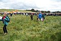
- Alwinton Border Shepherds Show
- Images gallery
- References
- External links
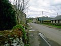
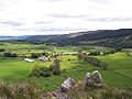
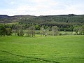
Alwinton lies at the head of the Coquet valley, on the edge of both the Otterburn Army Training Estate and the Northumberland National Park. The village is roughly 10 miles (16 km) from the border with Scotland, and about 18 miles (29 km) to the west of Alnwick.
The neighbouring village of Harbottle and Harbottle Castle are about 2.5 kilometres (1.6 mi) from Alwinton. A road continues past Alwinton into the Cheviot Hills where it terminates at the ancient Roman military encampment of Chew Green.
Having no shops, Alwinton's social life centres on the Rose and Thistle Inn, a public house owned by the Latchams. Regular Church of England services are offered at St. Michael and All Angels, which traditionally serves the parish of Alwinton encompassing the nearby townships of Biddlestone, Burradon, Clennell, Fairhaugh, Farnham, Linbriggs, Netherton, Peels, and Sharperton. In the early 21st century several of rural Northumberland's least populated parishes were merged into slightly larger units, and Alwinton was one example, being merged with the neighbouring Biddlestone (where from the Census 2011 the population is included).