
The River Coquet runs through the county of Northumberland, England, discharging into the North Sea on the east coast at Amble. It rises in the Cheviot Hills on the border between England and Scotland, and follows a winding course across the landscape ("Coquetdale"). The upper reaches are bordered by the Otterburn Ranges military training ground, and are crossed by a number of bridges built in the 20th century. It passes a number of small villages and hamlets, and feeds one of the lakes created by extraction of gravel that form the Caistron Nature Reserve, before reaching the town of Rothbury, where it is crossed by a grade II listed bridge. Below the town is Thrum Mill, a Grade II-listed water mill.

Bamburgh Castle, on the northeast coast of England, by the village of Bamburgh in Northumberland, is a Grade I listed building.

Monkseaton is an area of Whitley Bay, North Tyneside, in the county of Tyne and Wear, England. Historically in Northumberland, it is in the north-east of the borough, 3⁄4 mile from the North Sea coast and 1+1⁄2 mi (2.5 km) north of the River Tyne at North Shields. One mile to the north of Monkseaton, the extensive built-up areas of North Tyneside change abruptly into green belt stretching north into south-east Northumberland. It is at an elevation of 130 feet (40 m) above sea-level.

Sempringham is a village in the civil parish of Pointon and Sempringham, in the South Kesteven district of Lincolnshire, England. It is situated 2 miles (3.2 km) south from the A52 road, 12 miles (19 km) east from Grantham and 8 miles (13 km) north from Bourne. The hamlet is on the western edge of the Lincolnshire Fens, the closest village being Billingborough, 0.5 miles (0.8 km) to the north on the B1177 road. Sempringham is noted as the home of Gilbert of Sempringham, the son of the lord of the manor. Gilbert is the only English Saint to have founded a monastic order, the Gilbertines. In 1921 the parish had a population of 112. On 1 April 1931 the parish was abolished to form "Pointon and Sempringham".

Belton is a village in the civil parish of Belton and Manthorpe, in the South Kesteven district of Lincolnshire, England. It is situated on the A607 road, and 3 miles (5 km) north from the market town of Grantham. In 1921 the parish had a population of 145.

Tweedmouth is part of the town of Berwick-upon-Tweed in Northumberland, England. It is located on the south bank of the River Tweed and is connected to Berwick town centre, on the north bank, by two road bridges and a railway bridge. Tweedmouth has historically always been part of England, in contrast to the walled town of Berwick which came under Scottish control for several periods in the Middle Ages. The local nickname for people from Tweedmouth is "Twempies". In 1951 the parish had a population of 6410.

Bolam is a village and former civil parish, now in the parish of Belsay in the county of Northumberland, England. The village is about 20 miles (32 km) north-west of Newcastle upon Tyne, near Bolam West Houses. In 1951 the civil parish had a population of 60. On 1 April 1955 the parish was abolished and merged with Belsay.
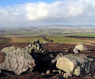
Cartington is a village and former civil parish, now in the parish of Thropton, in Northumberland, England. It is about 11 miles (18 km) south west of Alnwick, and about 2 miles (3 km) north west of Rothbury. In 2019 it had an adult population of 95, after having returned a population of 97 in 2001.
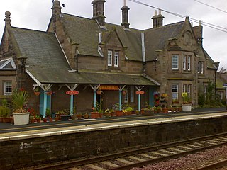
Chathill is a hamlet and former civil parish, now in the parish of Ellingham, in Northumberland, England. It is about 9 miles (14 km) north of Alnwick and 3 miles (5 km) inland from the North Sea coast. It is served by Chathill railway station. It is on the main road serving Seahouses and the northern coast. In 1951 the parish had a population of 59.

Elswick is a district and electoral ward of the city and metropolitan borough of Newcastle upon Tyne, in the county of Tyne and Wear, England, 1.9 miles west of the city centre, bordering the River Tyne. Historically in Northumberland, Elswick became part of Newcastle upon Tyne in 1835. Elswick is home to the Newcastle Utilita Arena; and Newcastle College, with approximately 45,000 students.

Backworth is a village in the metropolitan borough of North Tyneside in the county of Tyne and Wear, England, about 3+1⁄2 miles (6 km) west of Whitley Bay on the north east coast. It lies 5 miles (8 km) northeast of Newcastle upon Tyne. Other nearby towns include North Shields to the southeast, Wallsend to the south, and Cramlington to the northwest.

Sharperton is a small settlement and former civil parish, now in the parish of Harbottle, in Northumberland, England. Sharperton is the site of a deserted medieval village, which was documented as having 14 taxpayers in 1296, and described as having two short rows of dwellings in 1632. There was also a bastle here. In 1951 the parish had a population of 36.

Southwick is a village and former civil parish, now in the parish of Southwick and Widley, in the Winchester district, in Hampshire, England. 1 mile (1.6 km) north of the Portsmouth boundary measured from Portsea Island. Homes and farms in the village are influenced by the style of the Middle Ages apart from Church Lodge.

Stamfordham is a village and civil parish in Northumberland, England. The population of the civil parish at the 2001 Census was 1,047, rising to 1,185 at the 2011 Census. The place-name Stamfordham is first attested in the Pipe Rolls for 1188, where it appears as Stanfordhamn, which roughly translates as 'village at the stony ford'.
Newton on the Moor is a village and former civil parish in Northumberland, England. It is located 5 miles (8 km) south of Alnwick, on the old route of the A1 road although the village has now been bypassed just to the east. The village is now in the civil parish of Newton on the Moor and Swarland, which also includes the village of Swarland, south-west of Newton on the Moor. The population of Newton on the Moor and Swarland parish in 2001 was 822, increasing to 905 at the 2011 Census. The village is a conservation area.

Kirkhaugh is a very small village and former civil parish, now in the parish of Knaresdale with Kirkhaugh, adjacent to the River South Tyne in Northumberland, England. The village lies close to the A689 road north of Alston, Cumbria. In 1951 the parish had a population of 79.

Stapleton is a village and civil parish in the City of Carlisle district, in the county of Cumbria, in the North West of England. It falls under the jurisdiction of Cumberland Council.

Kilham is a hamlet and civil parish in the English county of Northumberland, located 8.0 miles (12.9 km) west of Wooler, 12.0 miles (19.3 km) east of Kelso, 17.0 miles (27.4 km) south west of Berwick-upon-Tweed and 38.9 miles (62.6 km) north west of Morpeth. It lies on the northern edge of the Northumberland National Park in Bowmont Valley Northumberland. The hamlet, which consists of a small group of agricultural dwellings, is overlooked by Kilham Hill and the northern limits of the Cheviot Hills. The parish had a population of 131 in 2001, and includes the hamlets of Howtel and Pawston, along with the former upland township of Coldsmouth and Thompson's Walls. falling to less than 100 at the 2011 Census. Details are now included in the parish of Branxton
Kingerby is a village and former civil parish, now in the parish of Osgodby, in the West Lindsey district of Lincolnshire, England. It is situated 5 miles (8.0 km) north west from the town of Market Rasen. The hamlet of Bishop Bridge lies about 1.5 miles (2.4 km) to the south-west. In 1931 the parish had a population of 75. On 1 April 1936 the parish was abolished to form Osgodby.

Glororum is a hamlet and former civil parish, now in the parish of Bamburgh in the county of Northumberland, England, about 1.25 miles (2.01 km) south west of Bamburgh. In 1951 the parish had a population of 13.

