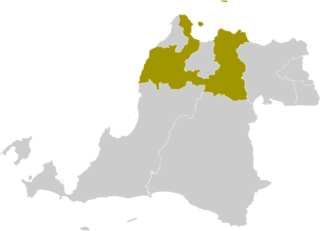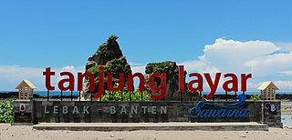
Serang Regency is a regency of Banten province, Indonesia. It is located in the northwest corner of the island of Java. The administrative center of the regency is at Ciruas, while the capital of the province is the independent municipality of Serang which was split off the regency on 17 July 2007.

Karawaci is a town and an administrative district (kecamatan) of Tangerang City, in Banten Province of Indonesia, on the island of Java. The district covers an area of 13.48 km2, and had a population of 171,317 at the 2010 Census and 184,388 at the 2020 Census; the official estimate as at mid 2023 was 193,480. Lippo Karawaci, a planned community, is located here.

Bogor Regency is a landlocked regency (kabupaten) of West Java province in Indonesia, situated south of DKI Jakarta. Covering an area of 2,734.33 km2, it is considered a bedroom community for Jakarta, and was home to 5,427,068 people at the 2020 census. The official estimate as at mid 2023 was 5,520,836. The town of Cibinong serves as the regency seat.

Sukabumi Regency is a regency (kabupaten) in southwestern Java, as part of West Java province of Indonesia. The regency seat is located in Palabuhan Ratu, a coastal district facing the Indian Ocean. The regency fully encircles the administratively separated city of Sukabumi. Covering an area of 4,164.15 km2, the regency is the largest regency in West Java and the second largest regency on Java after the Banyuwangi Regency in East Java. The regency had a population of 2,341,409 at the 2010 census and 2,725,450 at the 2020 census; the official estimate as at mid 2023 was 2,802,404, with a large proportion of it living in the northeastern part of the regency that encircles Sukabumi City, south of Mount Gede. A plan to create a new regency, the putative North Sukabumi Regency, was considered by the Indonesian government in 2013, but has been deferred until the end of the current morotorium on new creations of regencies.

Lebak Regency is a regency of Banten province, Indonesia. It is located on the island of Java. The regency has an area of 3,481.35 km2 and had a population of 1,204,095 at the 2010 census and 1,386,793 at the 2020 census; the official estimate as at mid 2023 was 1,480,593. The town of Rangkasbitung in the north of the regency is the administrative centre. The regency is bordered by the Pandeglang Regency to the west, the Serang Regency to the north, and the Tangerang Regency to the north-east, by the Bogor and Sukabumi regencies to the east, and by the Indian Ocean to the south.

Pandeglang Regency is a regency of Banten province, Indonesia. It is mainly located on the west and south coasts of the island of Java and is the most westerly regency on Java Island, but it also includes several offshore islands such as Panaitan, Peucang, Deli and Tinjil. It is bounded by Serang Regency to the north, Lebak Regency to the east, the Java Sea to the south, and the Sunda Strait to the west. The regency has a land area of 3,053.13 km2, and a population at the 2010 Census of 1,149,610, rising to 1,272,687 at the 2020 Census; the official estimate as of mid-2023 was 1,391,056. The regency seat is the town of Pandeglang in the northeast of the regency, but the most densely-populated district outside of the northeast agglomeration is the town of Labuan on the west coast.

Serang is a city and the capital of Banten province and was formerly also the administrative center of Serang Regency in Indonesia. The city is located towards the north of Banten province, on the island of Java; the north part of the city contains the coast zone facing onto Banten Bay, and includes the historical site of Old Banten, after which the province is named. Before Banten province was formed in 2000, Serang city was part of West Java province.

Benda is a town and an administrative district (kecamatan) of Tangerang City, in Banten Province of Indonesia, on the island of Java. The district covers an area of 5.92 km2, and had a population of 83,017 at the 2010 Census and 83,526 at the 2020 Census; the official estimate as at mid 2023 was 85,769. Jakarta's main international airport, Soekarno–Hatta International Airport is located in the district.
Cibodas is a town and an administrative district (kecamatan) of Tangerang City, in Banten Province of Indonesia, on the island of Java. The district covers an area of 9.61 km2, and had a population of 142,479 at the 2010 Census and 147,279 at the 2020 Census; the official estimate as at mid 2023 was 158,036.
Ciledug is an administrative district (kecamatan) of Tangerang City, in Banten Province of Indonesia, on the island of Java. The district covers an area of 8.77 km2, and had a population of 147,023 at the 2010 Census and 164,151 at the 2020 Census; the official estimate as at mid 2023 was 150,190.
Cipondoh is a town and an administrative district (kecamatan) of Tangerang City, in Banten Province of Indonesia, on the island of Java. The district covers an area of 17.91 km2, and had a population of 216,346 at the 2010 Census and 248,212 at the 2020 Census; the official estimate as at mid 2023 was 231,127.
Jatiuwung is an administrative district (kecamatan) of Tangerang City, in Banten Province of Indonesia, on the island of Java. It is the most westerly district of the city, and is surrounded by Tangerang Regency on its north, west and south sides. It covers an area of 14.41 km2, and had a population of 120,216 at the 2010 Census and 102,053 at the 2020 Census; the official estimate as at mid 2023 was 107,510.

Karangtengah is a town and an administrative district (kecamatan) of Tangerang City, in Banten Province of Indonesia, on the island of Java. The district covers an area of 10.47 km2, and had a population of 118,473 at the 2010 Census and 117,721 at the 2020 Census; the official estimate as at mid 2023 was 117,440.
Larangan is a town and an administrative district (kecamatan) of Tangerang City, in Banten Province of Indonesia, on the island of Java. The district covers an area of 9.40 km2, and had a population of 163,901 at the 2010 Census and 165,599 at the 2020 Census; the official estimate as at mid 2023 was 151,860.
Neglasari is a town and an administrative district (kecamatan) of Tangerang City, in Banten Province of Indonesia, on the island of Java. The district covers an area of 16.08 km2, and had a population of 103,504 at the 2010 Census and 115,520 at the 2020 Census; the official estimate as at mid 2023 was 124,907.
Periuk is a town and an administrative district (kecamatan) of Tangerang City, in Banten Province of Indonesia, on the island of Java. The district covers an area of 9.54 km2, and had a population of 129,384 at the 2010 Census and 141,003 at the 2020 Census; the official estimate as at mid 2023 was 144,640.
Tangerang District is an administrative district of Tangerang City, in Banten Province of Indonesia, on the island of Java. It covers an area of 15.79 km2, and had a population of 126,244 at the 2010 Census and 153,859 at the 2020 Census; the official estimate as at mid 2023 was 165,575.

Ciputat is a town and an administrative district (kecamatan) in the city of South Tangerang, in Banten Province on Java, Indonesia and is inside the Greater Jakarta metropolitan area. It covers an area of 21.11 km2 and had a population of 192,205 at the 2010 Census and 202,722 at the 2020 Census; the official estimate as at mid 2023 was 222,186.

Pamulang is a town and an administrative district (kecamatan) within the city of South Tangerang, in Banten Province on Java, Indonesia. The district covers an area of 28.74 km2 and had a population of 286,270 at the 2010 Census and 305,563 at the 2020 Census; the official estimate as at mid 2023 was 324,059.
Serpong is a town and an administrative district (kecamatan) of South Tangerang city, in Banten Province on Java, Indonesia. Before South Tangerang City became an autonomous city, Serpong District was one of the districts of Tangerang Regency. It covers an area of 28.27 km2, and had a population of 137,212 at the 2010 Census and 154,744 at the 2020 Census; the official estimate as at mid 2023 was 163,451. The district is sub-divided into nine kelurahan.


