Bazaar Township, Chase County, Kansas

Last updated

Bazaar Township
Map highlighting Bazaar Township, Chase County, Kansas.svg
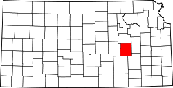
Location within Chase County
USA Kansas location map.svg
Red pog.svg
Bazaar Township
Location within the state of Kansas
Coordinates: 38°15′10″N096°29′31″W / 38.25278°N 96.49194°W / 38.25278; -96.49194
Country United States
State Kansas
County Chase
Area
  Total
293 km2 (113 sq mi)
  Land292.5 km2 (112.9 sq mi)
  Water0.5 km2 (0.19 sq mi)  0.17%
Elevation
417 m (1,368 ft)
Population
 (2000)
  Total
81
  Density0.3/km2 (0.78/sq mi)
GNIS feature ID 0477413

Bazaar Township is a township in Chase County, Kansas, United States. As of the 2000 census, its population was 81.

Contents

Geography

Bazaar Township covers an area of 113.13 square miles (293.0 km2). The streams of Baker Creek, Den Creek, East Branch Sharpes Creek, Folsom Creek, Kirk Creek, Nickel Creek, Norton Creek, Rock Creek, Sharpes Creek and Yeager Creek run through this township.

In what remains of the community of Bazaar, the Bazaar United Methodist Church continues to hold weekly worship services at 8:30 each Sunday morning except for the first weekend in June when Chase County churches meet at the Strong City Rodeo grounds for Cowboy Church.

Communities

The township contains the following settlements:

Cemeteries

The township contains the following cemeteries:

See also

Further reading

References