
The Santa Susana Mountains are a transverse range of mountains in Southern California, north of the city of Los Angeles, in the United States. The range runs east-west, separating the San Fernando and Simi valleys on its south from the Santa Clara River Valley to the north and the Santa Clarita Valley to the northeast. The Oxnard Plain is to the west of the Santa Susana Mountains.
Newhall Pass is a low mountain pass in Los Angeles County, California. Historically called Fremont Pass and San Fernando Pass, with Beale's Cut, it separates the Santa Susana Mountains from the San Gabriel Mountains. Although the pass was visited in August 1769 by Catalan explorer Gaspar de Portolá, it eventually was named for Henry Newhall, a significant businessman in the area during the 19th century.
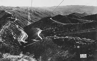
The Ridge Route, officially the Castaic–Tejon Route, was a two-lane highway between Los Angeles County and Kern County, California. Opened in 1915 and paved with concrete between 1917 and 1921, the road was the first paved highway directly linking the Los Angeles Basin with the San Joaquin Valley over the Tejon Pass and the rugged Sierra Pelona Mountains ridge south of Gorman. Much of the old road runs through the Angeles National Forest, and passes many historical landmarks, including the National Forest Inn, Reservoir Summit, Kelly's Half Way Inn, Tumble Inn, and Sandberg's Summit Hotel. North of the forest, the Ridge Route passed through Deadman's Curve before ending at Grapevine.

Edward Fitzgerald "Ned" Beale was a national figure in the 19th-century United States. He was a naval officer, military general, explorer, frontiersman, Indian affairs superintendent, California rancher, diplomat, and friend of Kit Carson, Buffalo Bill Cody and Ulysses S. Grant. He fought in the United States-Mexican War, emerging as a hero of the Battle of San Pasqual in 1846. He achieved national fame in 1848 in carrying to the east the first gold samples from California, contributing to the gold rush.

The Santa Susana Pass, originally Simi Pass, is a low mountain pass in the Simi Hills of Southern California, connecting the San Fernando Valley and Los Angeles neighborhood of Chatsworth, to the city of Simi Valley and eponymous valley.

Newhall is the southernmost and oldest community in the city of Santa Clarita, California. Prior to the 1987 consolidation of Canyon Country, Saugus, Newhall, and Valencia into the city of Santa Clarita, it was an unincorporated area. It was the first permanent town in the Santa Clarita Valley.

Soledad Canyon is a long narrow canyon/valley located in Los Angeles County, California between the cities of Palmdale and Santa Clarita. It is a part of the Santa Clara River Valley, and extends from the top of Soledad Pass to the open plain of the valley in Santa Clarita. The upstream section of the Santa Clara River runs through it.

Andrés Pico was a Californio who became a successful rancher, fought in the contested Battle of San Pascual during the Mexican–American War, and negotiated promises of post-war protections for Californios in the 1847 Treaty of Cahuenga. After California became one of the United States, Pico was elected to the state Assembly and Senate. He was appointed as the commanding brigadier general of the state militia during the U.S. Civil War.

San Francisquito Canyon is a canyon created through erosion of the Sierra Pelona Mountains by the San Francisquito Creek, in Los Angeles County, Southern California.

San Fernando Road is a major street in the City of Los Angeles and Los Angeles County. Within the Burbank city limits it is signed as San Fernando Boulevard, and north of Newhall Pass it is signed as The Old Road. It was previously designated as Business Loop 5 in the 1970s.
Sierra Highway or El Camino Sierra is a road in Southern California, United States. El Camino Sierra refers to the full length of a trail formed in the 19th century, rebuilt as highways in the early 20th century, that ran from Los Angeles to Lake Tahoe following parts of modern State Route 14, U.S. Route 395 and State Route 89. Two portions of this road are currently signed as Sierra Highway. The first is an old alignment of SR 14/U.S. Route 6 from Los Angeles to Mojave. This road is also signed with the unusual designation of State Route 14U through the city of Santa Clarita. The second part signed as Sierra Highway is a portion of US 395 in Bishop.
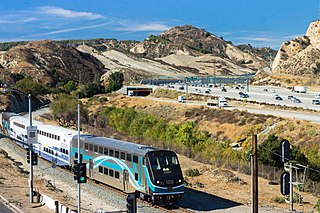
Santa Clarita is a city in northwestern Los Angeles County in the U.S. state of California. With a 2020 census population of 228,673, it is the third-most populous city in Los Angeles County, the 17th-most populous in California, and the 103rd-most populous city in the United States. It is located about 30 miles (48 km) northwest of downtown Los Angeles, and occupies 70.75 square miles (183.2 km2) of land in the Santa Clarita Valley, along the Santa Clara River. It is a classic example of a U.S. edge city, satellite city, or boomburb.

John Butterfield was a transportation pioneer in the mid-19th century in the American Northwest and Southwest. He founded many companies, including American Express which is still in operation today. The Butterfield Overland Mail Company was the longest stagecoach line in the world. The line operated from 1858 to 1861 on the Southern Overland Trail and established an important connection between the new state of California and the government and economy of the contiguous eastern states.

The Old Santa Susana Stage Road, or Santa Susana Wagon Road, is a route taken by early travelers between the San Fernando Valley and Simi Valley near Chatsworth, California, via the Santa Susana Pass. The main route climbs through what is now the Santa Susana Pass State Historic Park, with a branch in Chatsworth Park South.
The history of the San Fernando Valley from its exploration by the 1769 Portola expedition to the annexation of much of it by the City of Los Angeles in 1915 is a story of booms and busts, as cattle ranching, sheep ranching, large-scale wheat farming, and fruit orchards flourished and faded. Throughout its history, settlement in the San Fernando Valley was shaped by availability of reliable water supplies and by proximity to the major transportation routes through the surrounding mountains.
James Russell Vineyard was an American Democratic politician and pioneer. He served in the California State Senate and Assembly, and earlier was a member of the Wisconsin State Assembly, the legislature of the Wisconsin Territory and the 7th Michigan Territorial Council. He was infamous for shooting and killing fellow Wisconsin territorial legislator Charles C. P. Arndt on the floor of the legislature.

The Lyons Station Stagecoach Stop,, was a tavern and stagecoach stop near the southwest corner of Newhall Avenue and Sierra Highway, by Eternal Valley Cemetery. The site is located in the present day Newhall section of Santa Clarita, in Los Angeles County, California.
San Francisquito Pass is a mountain pass in the Sierra Pelona Mountains, located northeast of Green Valley and Santa Clarita, in northern Los Angeles County, California.
King's Station, also known as Moore's and Hollandsville, was a stagecoach station of the Butterfield Overland Mail 1st Division between 1858 and 1861 in southern California.
George Cady Carson (1832–1901) was a merchant, road builder, rancher and member of the Los Angeles, California, Common Council in the 1850s.


