Beattock

Last updated

Beattock
Old Brig Inn.jpg
The Old Brig Inn, a coaching inn on the old A74 road at Beattock.
Dumfries and Galloway UK location map.svg
Red pog.svg
Beattock
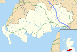
Location within Dumfries and Galloway
Council area
Lieutenancy area
Country Scotland
Sovereign state United Kingdom
Post town MOFFAT
Postcode district DG10
Dialling code 01683
Police Scotland
Fire Scottish
Ambulance Scottish
UK Parliament
Scottish Parliament
List of places
UK
Scotland
55°18′29″N3°27′29″W / 55.308°N 3.458°W / 55.308; -3.458 Coordinates: 55°18′29″N3°27′29″W / 55.308°N 3.458°W / 55.308; -3.458

Beattock is a village in Dumfries and Galloway, Scotland, approximately 12 mile (800 metres) southwest of Moffat and 19 miles (31 kilometres) north of Dumfries.

Beattock was historically served by the A74 road and the West Coast Main Line, however the road has since been upgraded to the A74(M) motorway and no longer passes through the village. Beattock railway station was closed in 1972.

Beattock Summit is located approximately 10 miles (16 km) to the north of the village in the neighbouring administrative area of South Lanarkshire. At 1,033 ft (315 m) it is the highest point on both the M74, and on the West Coast Main Line within Scotland. The poet W. H. Auden's 1936 work Night Mail makes reference to the summit.

The Southern Upland Way [1] and the Annandale Way [2] run close to the village.
Governance

Beattock is in the parliamentary constituency of Dumfriesshire, Clydesdale and Tweeddale, David Mundell is the current Conservative Party member of parliament.

Ecclefechan is part of the South Scotland region in the Scottish Parliament, being in the constituency of Dumfriesshire. Oliver Mundell of the Conservatives is the MSP.

Before Brexit, for the European Parliament its residents voted to elect MEP's for the Scotland constituency.

Related Research Articles

<span class="mw-page-title-main">Dumfries</span> Town in Dumfries and Galloway, Scotland

Dumfries is a market town and former royal burgh within the Dumfries and Galloway council area of Scotland. It is located near the mouth of the River Nith into the Solway Firth about 25 miles (40 km) by road from the Anglo-Scottish border and just 15 miles (24 km) away from Cumbria by air. Dumfries is the county town of the historic county of Dumfriesshire.

<span class="mw-page-title-main">Dumfries and Galloway</span> Council area of Scotland

Dumfries and Galloway is one of 32 unitary council areas of Scotland and is located in the western Southern Uplands. It covers the historic counties of Dumfriesshire, Kirkcudbrightshire, and Wigtownshire, the latter two of which are collectively known as Galloway. The administrative centre and largest settlement is the town of Dumfries. The second largest town is Stranraer, on the North Channel coast, some 57 miles (92 km) to the west of Dumfries.

Ecclefechan is a small village located in Dumfries and Galloway in the south of Scotland.

<span class="mw-page-title-main">Scottish Borders</span> Council area of Scotland

The Scottish Borders is one of 32 council areas of Scotland. It borders the City of Edinburgh, Dumfries and Galloway, East Lothian, Midlothian, South Lanarkshire, West Lothian and, to the south-west, south and east, the English counties of Cumbria and Northumberland. The administrative centre of the area is Newtown St Boswells.

<span class="mw-page-title-main">Langholm</span> Human settlement in Scotland

Langholm, also known colloquially as the "Muckle Toon", is a burgh in Dumfries and Galloway, southern Scotland. Langholm lies between four hills in the valley of the River Esk in the Southern Uplands.

<span class="mw-page-title-main">Dumfriesshire</span> Historic county in Scotland

Dumfriesshire or the County of Dumfries or Shire of Dumfries is a historic county and registration county in southern Scotland. The Dumfries lieutenancy area covers a similar area to the historic county.

<span class="mw-page-title-main">Annandale, Dumfries and Galloway</span> Valley in Dumfries and Galloway, Scotland

Annandale is a strath in Dumfries and Galloway, Scotland, named after the dale of the River Annan. It runs north–south through the Southern Uplands from Annanhead to Annan on the Solway Firth, and in its higher reaches it separates the Moffat hills on the east from the Lowther hills to the west. A 53-mile (85 km) long-distance walking route called Annandale Way running through Annandale was opened in September 2009.

<span class="mw-page-title-main">Southern Uplands</span> Southernmost and least populous region of Scotland

The Southern Uplands are the southernmost and least populous of mainland Scotland's three major geographic areas. The term is used both to describe the geographical region and to collectively denote the various ranges of hills and mountains within this region. An overwhelmingly rural and agricultural region, the Southern Uplands are partly forested and contain many areas of open moorland - the hill names in the area are congruent with these characteristics.

<span class="mw-page-title-main">Dumfriesshire, Clydesdale and Tweeddale (UK Parliament constituency)</span> Parliamentary constituency in the United Kingdom, 2005 onwards

Dumfriesshire, Clydesdale and Tweeddale is a constituency of the House of Commons, located in the South of Scotland, within the Dumfries and Galloway, South Lanarkshire and Scottish Borders council areas. It elects one Member of Parliament (MP) at least once every five years using the First-past-the-post system of voting. It is currently represented in Westminster by the former Secretary of State for Scotland, David Mundell, a Conservative, who has been the MP since 2005.

<span class="mw-page-title-main">David Mundell</span> Scottish politician and solicitor

David Gordon Mundell, is a Scottish politician and solicitor who served as Secretary of State for Scotland from 2015 to 2019. A member of the Scottish Conservative Party, he has served as the Member of Parliament (MP) for Dumfriesshire, Clydesdale and Tweeddale since 2005. Mundell was the first openly gay Conservative cabinet minister, formally coming out in 2016.

<span class="mw-page-title-main">Lochmaben</span> Human settlement in Scotland

Lochmaben is a small town and civil parish in Scotland, and site of a castle. It lies 4 miles (6 km) west of Lockerbie, in Dumfries and Galloway. By the 12th century the Bruce family had become the local landowners and, in the 14th century, Edward I rebuilt Lochmaben Castle. It was subsequently taken by Archibald Douglas, 3rd Earl of Douglas in 1384/5 and was abandoned in the early 17th century. The town itself became a Royal Burgh in 1447.

<span class="mw-page-title-main">Abington, South Lanarkshire</span> Human settlement in Scotland

Abington is a village in the Scottish council region of South Lanarkshire, close to the M74 motorway, marking the point where it changes name to the A74(M), following the upgrade of the former A74 road. The West Coast Main Line between Glasgow and London also emerges from the Clyde Valley at this point and begins its ascent up Beattock Summit, alongside the motorway. Abington was at one time served by a station on the railway, but this was closed as a result of the Beeching cuts of the 1960s.

<span class="mw-page-title-main">Southern Upland Way</span> Long-distance footpath in Scotland

The Southern Upland Way is a 344-kilometre (214 mi) coast-to-coast long-distance footpath in southern Scotland. The route links Portpatrick in the west and Cockburnspath in the east via the hills of the Southern Uplands. The Way is designated as one of Scotland's Great Trails by NatureScot and is the longest of the 29 Great Trails. The Southern Upland Way meets with seven of the other Great Trails: the Annandale Way, the Berwickshire Coastal Path, the Borders Abbeys Way, the Cross Borders Drove Road, the Mull of Galloway Trail, the Romans and Reivers Route and St Cuthbert's Way.

Eastriggs is a small village located in Dumfries and Galloway in the south of Scotland, the village is located around 2 mi (3.2 km) north of the mud and sandbanks of the channel of the River Eden, which extends west into the Solway Firth.

Johnstonebridge is a village in Dumfries and Galloway, Scotland.

<span class="mw-page-title-main">Newton Wamphray</span> Human settlement in Scotland

Newton Wamphray is a village in Dumfries and Galloway. Wamphray is the name of the surrounding parish and of the Wamphray Water, which flows south-west through the Wamphray Glen to join the River Annan near the small village, or hamlet, of Newton.

<span class="mw-page-title-main">Moffat</span> Human settlement in Scotland

Moffat is a burgh and parish in Dumfriesshire, now part of the Dumfries and Galloway local authority area in Scotland. It lies on the River Annan, with a population of around 2,500. It was a centre of the wool trade and a spa town.

<span class="mw-page-title-main">Lowther Hills</span> Geographical object in Dumfries and Galloway, Scotland, UK

The Lowther Hills, also sometimes known as the Lowthers, are an extensive area of hill country in the Southern Uplands of Scotland, though some sub-ranges of hills in this area also go under their own local names - see "Hillwalking" below. They form a roughly rhomboidal or lozenge shape on the map with the acute angles being to north and south. It has river valleys along its boundaries to north east (Clydesdale) and south west (Nithsdale) which carry the two largest arterial routes northwards into the west side of the Central Belt of Scotland. A string of small towns have long since developed along these routes. Most of the Lowther Hills lie in the Administrative County of Dumfries and Galloway, though part in the administrative county of South Lanarkshire moves into them around the village of Leadhills and the Daer Reservoir.

<span class="mw-page-title-main">Dumfriesshire (Scottish Parliament constituency)</span> Region or constituency of the Scottish Parliament

Dumfriesshire is a constituency of the Scottish Parliament (Holyrood) covering part of the council area of Dumfries and Galloway. It elects one Member of the Scottish Parliament (MSP) by the plurality method of election. It is also one of nine constituencies in the South Scotland electoral region, which elects seven additional members, in addition to nine constituency MSPs, to produce a form of proportional representation for the region as a whole.

This article describes the Caledonian Railway from its conception down to the year 1850.

References

  1. "Southern Upland Way website". Archived from the original on 15 March 2012. Retrieved 23 February 2012.
  2. Annandale Way website