
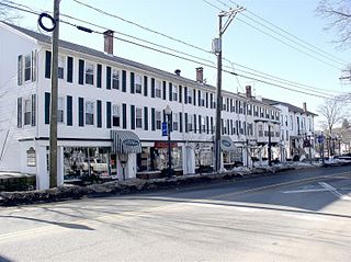
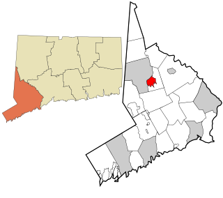
Brookfield is a town in Fairfield County, Connecticut, United States, situated within the southern foothills of the Berkshire Mountains. The population was 17,528 at the 2020 census. The town is located 55 miles (89 km) northeast of New York City, making it part of the New York metropolitan area. In July 2013, Money magazine ranked Brookfield the 26th-best place to live in the United States, and the best place to live in Connecticut.

Fairfield County is a county in the southwestern corner of the U.S. state of Connecticut. It is the most populous county in the state and was also its fastest-growing from 2010 to 2020. As of the 2020 census, the county's population was 957,419, representing 26.6% of Connecticut's overall population. The closest to the center of the New York metropolitan area, the county contains four of the state's top 7 largest cities—Bridgeport (1st), Stamford (2nd), Norwalk (6th), and Danbury (7th)—whose combined population of 433,368 is nearly half the county's total population.
Bethel is a town in Fairfield County, Connecticut, United States. As of the 2020 census, the population of the town was 20,358. The town includes the Bethel Census Designated Place. Interstate 84 passes through Bethel, and it has a train station on the Danbury Branch of Metro-North's New Haven Line.
Danbury is a city in Fairfield County, Connecticut, United States, located approximately 50 miles (80 km) northeast of New York City. Danbury's population as of 2020 was 86,518. It is the seventh largest city in Connecticut.
Bethel is a census-designated place (CDP) in Fairfield County, Connecticut, United States. It comprises the primary village and surrounding residential land within the town of Bethel. As of the 2010 census, the population of the CDP was 9,549, out of 18,584 in the entire town.

Area codes 203 and 475 are telephone area codes in the North American Numbering Plan (NANP) for the southwestern part of the U.S. state of Connecticut. The numbering plan area (NPA) is mostly coextensive with the Connecticut portion of the New York metropolitan area, and comprises most of Fairfield County, all of New Haven County, and a small portion of Litchfield County.

Route 58 is a primary state highway in the U.S. state of Connecticut connecting the towns of Fairfield and Bethel. Route 58 is 18.58 miles (29.90 km) long and is one of the primary routes to the downtown Danbury area via Routes 302 and 53.

Route 53 is a state highway in the U.S. state of Connecticut, connecting the cities of Norwalk and Danbury. Most of the route has been made redundant by U.S. Route 7, except for the last section from Bethel to Danbury, which is part of a direct route from the Bridgeport area to Danbury.

The Still River is a 25.4-mile-long (40.9 km) tributary to the Housatonic River in western Connecticut.

Housatonic Area Regional Transit, known popularly as HARTransit, is the provider of public transportation for Danbury, Connecticut and surrounding communities. HARTransit was founded in 1972 as the Danbury-Bethel Transit District by the two municipalities. The name was changed to Housatonic Area Regional Transit in 1979 after the addition of other municipal members. The agency receives funding from municipal contracts, the Connecticut Department of Transportation, Federal Transit Administration and the New York State Department of Transportation. Prior to HARTransit's establishment, Danbury had gone without transit service since 1967 when the privately owned ABC Bus Company which had replaced the Candlewood Bus Company a few months before, ceased operations. The first local bus transit operator in the area, Danbury Power & Transportation Company, operated bus services in Danbury and Bethel from 1926 to 1965. HARTransit provides service to a greater number of towns than its predecessors.

Greater Bridgeport is the metropolitan area centered on the city of Bridgeport in the U.S. state of Connecticut. The area is located in Southwestern Connecticut. In its most conservative form the area consists of the city of Bridgeport and five surrounding towns—Easton, Fairfield, Monroe, Stratford, and Trumbull. This definition of the Bridgeport area has a population of more than 305,000 and is within the Bridgeport-Stamford-Norwalk-Danbury metropolitan statistical area, which consists of all of Fairfield County, Connecticut. The estimated 2015 county population was 948,053. The area is numbered as part of the New York-Newark Combined Statistical Area NY-NJ-CT-PA by the United States Census Bureau.

The News-Times is a daily newspaper based in Danbury, Connecticut, United States. It is owned and operated by the Hearst Corporation.
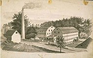
The History of Brookfield, Connecticut extends back roughly three centuries.

The Pequonnock River is a 16.7-mile-long (26.9 km) waterway in eastern Fairfield County, Connecticut. Its watershed is located in five communities, with the majority of it located within Monroe, Trumbull, and Bridgeport. The river has a penchant for flooding, particularly in spring since the removal of a retention dam in Trumbull in the 1950s. There seems to be a sharp difference of opinion among historians as to just what the Indian word Pequonnock signifies. Some insist it meant cleared field or open ground; others are sure it meant broken ground; while a third group is certain it meant place of slaughter or place of destruction.

St. Peter is a Roman Catholic church in Danbury, Connecticut, part of the Diocese of Bridgeport. St. Peter's was the first Catholic church built in northern Fairfield County. It is the third oldest parish, and the fifth oldest Roman Catholic Church in the Diocese of Bridgeport. St. Peter's was originally a predominantly Irish congregation. Danbury's Annual St. Patrick's Day Parade steps off in front of St. Peter's. In more recent time, the parish has a significant number of parishioners of Latino and Brazilian heritage.

The Danbury and Bethel Street Railway was a streetcar transit operator serving the greater Danbury, Connecticut, area, originally chartered in 1886. It was one of the few trolley companies to remain independent of the Connecticut Company consolidation of transit lines throughout the state. Electric trolley service between Danbury and Bethel began in 1887. The streetcar line connected to the Danbury and Harlem Traction Company at the Fairgrounds, but no service was provided and the line was abandoned by 1910. The Danbury and Bethel Street Railway faced its first financial difficulties in 1914 as ridership declined with the closure of local factories. The construction of an aborted extension to Bridgeport had nearly exhausted the railway's cash reserves. The company was purchased by J. Moss Ives in 1918 with the intention of bringing the operation back to profitability. The first buses were ordered and put into operation in 1912 between Main Street and Lake Avenue in Danbury. Ives reorganized as the Danbury and Bethel Traction Company in 1925. When the proposal to replace all remaining streetcar lines with bus operation was announced, the trolley motormen all went on strike in November 1926. The work stoppage did not affect the transition, and by the end of 1926 all streetcar operation had been abandoned, making it the first line in Connecticut to completely convert to bus operation.

Mill Plain is an unincorporated area in the City of Danbury, Connecticut, United States. It is located in the westernmost part of the city, bordering the town of Southeast, New York.

Miry Brook is an unincorporated area in the City of Danbury in Fairfield County, Connecticut. It is located in the western part of the city, bordering Mill Plain to the north and west at Lake Kenosia and the town of Ridgefield, Connecticut, to the southwest. The Danbury Airport is located in Miry Brook.

Great Plain is an unincorporated area in the City of Danbury, Fairfield County, Connecticut. A former farming community, only remnants exist of this once thriving agricultural hub. It is located in the northeast section of the city, sharing a border with the Beaverbrook area of Danbury and Brookfield, CT.


