North Dakota is a U.S. state in the Upper Midwest, named after the indigenous Dakota Sioux. It is bordered by the Canadian provinces of Saskatchewan and Manitoba to the north and by the U.S. states of Minnesota to the east, South Dakota to the south, and Montana to the west. North Dakota is part of the Great Plains region, characterized by broad prairies, steppe, temperate savanna, badlands, and farmland. It is believed to host the geographic center of North America, Rugby, and is home to the tallest artificial structure in the Western Hemisphere, the KVLY-TV mast.

Walsh County is a county in the U.S. state of North Dakota. As of the 2020 census, the population was 10,563. Its county seat is Grafton.
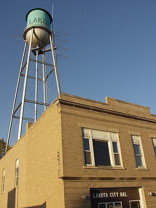
Nelson County is a county in the U.S. state of North Dakota. As of the 2020 census, the population was 3,015. Its county seat is Lakota.

Grand Forks County is a county in the U.S. state of North Dakota. As of the 2020 census, its population was 73,170, making it the third-most populous county in North Dakota. Its county seat and largest community is Grand Forks.
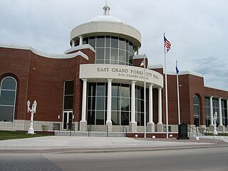
East Grand Forks is a city in Polk County, Minnesota, United States. The population was 9,176 at the 2020 Census, making it the largest community in Polk County.

Grand Forks is the 3rd most populous city in the U.S. state of North Dakota and the county seat of Grand Forks County. According to the 2020 census, the city's population was 59,166. Grand Forks, along with its twin city of East Grand Forks, Minnesota, forms the center of the Grand Forks, ND-MN Metropolitan Statistical Area, which is often called Greater Grand Forks or the Grand Cities.
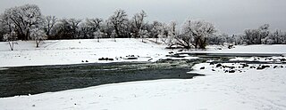
The Red River is a river in the north-central United States and central Canada. Originating at the confluence of the Bois de Sioux and Otter Tail rivers between the U.S. states of Minnesota and North Dakota, it flows northward through the Red River Valley, forming most of the border of Minnesota and North Dakota and continuing into Manitoba. It empties into Lake Winnipeg, whose waters join the Nelson River and ultimately flow into Hudson Bay.

The Red River flood of 1997 was a major flood that occurred in April and May 1997 along the Red River of the North in Minnesota, North Dakota, and southern Manitoba. It was the most severe flood of the river since 1826. The flood reached throughout the Red River Valley, affecting the cities of Fargo and Winnipeg, but none so greatly as Grand Forks and East Grand Forks, where floodwaters reached more than 3 miles (4.8 km) inland. They inundated virtually everything in the twin communities. Total damages for the Red River region were US$3.5 billion. The flood was the result of abundant snowfall and extreme temperatures.

The Alerus Center is an indoor arena and convention center in the north central United States, located in Grand Forks, North Dakota. The facility is owned and operated by the city of Grand Forks and opened on February 10, 2001.

"Greater Grand Forks" is the name used by some people to designate the twin cities of Grand Forks, North Dakota and East Grand Forks, Minnesota, together with their surrounding areas. The two cities lie directly across from each other on both sides of the Red River of the North, but Grand Forks, with a population of 59,166, is more than five times larger than East Grand Forks, with a population of 9,176. The metropolitan area includes all of the related two counties in the two states: Grand Forks County in North Dakota and Polk County in Minnesota. As of the 2020 census, the MSA had a population of 104,362, and in 2021 estimates placed the total population at 103,462.

Cities Area Transit (CAT) is the public transportation system in the neighboring cities of Grand Forks, North Dakota and East Grand Forks, Minnesota. The scheduled transit bus routes are operated by the city of Grand Forks and service is provided to East Grand Forks through a cost-sharing agreement. Paratransit for those who are unable to use the regular bus under the ADA, and a service for seniors, are provided under contract by Grand Forks Taxi.
The Red River flood of 1997 in the United States was a major flood that occurred in April 1997, along the Red River of the North in North Dakota and Minnesota. The flood reached throughout the Red River Valley, affecting the cities of Fargo, Moorhead, and Winnipeg, while Grand Forks and East Grand Forks received the most damage, where floodwaters reached over 3 miles (5 km) inland, inundating virtually everything in the twin communities. Total damages for the Red River region were US$3.5 billion.

The 2008 United States presidential election in North Dakota took place on November 4, 2008, and was part of the 2008 United States presidential election. Voters chose three representatives, or electors to the Electoral College, who voted for president and vice president.

This is a list of the National Register of Historic Places listings in Grand Forks County, North Dakota. This is intended to be a complete list of the properties and districts on the National Register of Historic Places in Grand Forks County, North Dakota, United States. The locations of National Register properties and districts for which the latitude and longitude coordinates are included below, may be seen in an online map.

Grand Forks County Fairgrounds WPA Structures is a collection of five structures within the Grand Forks County Fairgrounds in Grand Forks, North Dakota, that were listed on the National Register of Historic Places in 2009.

The 2012 North Dakota gubernatorial election was held on November 6, 2012 to elect a Governor and Lieutenant Governor of North Dakota, concurrently with the 2012 U.S. presidential election, as well as elections to the United States Senate, elections to the United States House of Representatives and various state and local elections. Incumbent Governor Jack Dalrymple succeeded to the office when then-Governor John Hoeven resigned to take a seat in the U.S. Senate in 2010. Dalrymple, a member of the Republican Party, won election to a full term. Ryan Taylor was the Democratic nominee. Dalrymple prevailed with 63% of the vote.

A Norwegian Dakotan is a Norwegian American in the U. S. states of North and South Dakota. One in three of all North Dakotans is of Norwegian heritage, which is the highest among all U.S. states. South Dakota is number three, behind Minnesota. The immigrants settled primarily between 1870 and 1920.

McLain Joseph Schneider is an American attorney and politician who has served as the United States attorney for the District of North Dakota since December 2022. He previously represented the 42nd district in the North Dakota Senate from 2009 until his reelection defeat in 2016. A member of the North Dakota Democratic-NPL Party, he served as the Senate Minority Leader from 2013 until the end of his Senate tenure. He was the Democratic-NPL endorsed candidate for the 2018 United States House of Representatives election in North Dakota.

The COVID-19 pandemic in North Dakota is an ongoing viral pandemic of coronavirus disease 2019 (COVID-19), a novel infectious disease caused by severe acute respiratory syndrome coronavirus 2 (SARS-CoV-2). The state reported its first case on March 11, 2020.


