Reynolds, North Dakota

Last updated

Reynolds, North Dakota
ND Grand Forks County Reynolds.svg
Location of Reynolds, North Dakota
Coordinates: 47°40′07″N97°06′21″W / 47.66861°N 97.10583°W / 47.66861; -97.10583
CountryUnited States
State North Dakota
Counties Traill, Grand Forks
Metro Greater Grand Forks
Founded1881
Area
[1]
  Total0.78 sq mi (2.02 km2)
  Land0.78 sq mi (2.02 km2)
  Water0.00 sq mi (0.00 km2)
Elevation
[2]
909 ft (277 m)
Population
 (2020) [3]
  Total277
  Estimate 
(2022) [4]
270
  Density355.58/sq mi (137.38/km2)
Time zone UTC-6 (Central (CST))
  Summer (DST) UTC-5 (CDT)
ZIP code
58275
Area code 701
FIPS code 38-66260
GNIS feature ID1036236 [2]
Website reynoldsnd.com

Reynolds is a city in Grand Forks and Traill counties in the State of North Dakota. It is part of the Grand Forks, ND-MN Metropolitan Statistical Area or "Greater Grand Forks". The population was 277 at the 2020 census. [3] Reynolds, named for pioneer settler Dr. Henry Reynolds, [5] was founded in 1881.

Contents

Geography

According to the United States Census Bureau, the city has a total area of 0.67 square miles (1.74 km2), all land. [6]

The southern section of Reynolds is actually in Traill County.

Demographics

Historical population
CensusPop.Note
1900 389
1910 4125.9%
1920 389−5.6%
1930 351−9.8%
1940 315−10.3%
1950 3356.3%
1960 269−19.7%
1970 236−12.3%
1980 30930.9%
1990 299−3.2%
2000 35017.1%
2010 301−14.0%
2020 277−8.0%
2022 (est.)270 [4] −2.5%
U.S. Decennial Census [7]
2020 Census [3]

2010 census

As of the census of 2010, there were 301 people, 125 households, and 88 families living in the city. The population density was 449.3 inhabitants per square mile (173.5/km2). There were 127 housing units at an average density of 189.6 per square mile (73.2/km2). The racial makeup of the city was 97.7% White, 0.7% African American, 1.0% Native American, and 0.7% Asian. Hispanic or Latino of any race were 2.3% of the population.

There were 125 households, of which 34.4% had children under the age of 18 living with them, 62.4% were married couples living together, 4.8% had a female householder with no husband present, 3.2% had a male householder with no wife present, and 29.6% were non-families. 29.6% of all households were made up of individuals, and 11.2% had someone living alone who was 65 years of age or older. The average household size was 2.41 and the average family size was 2.98.

The median age in the city was 41.1 years. 24.6% of residents were under the age of 18; 5.6% were between the ages of 18 and 24; 29.6% were from 25 to 44; 29.2% were from 45 to 64; and 11% were 65 years of age or older. The gender makeup of the city was 48.8% male and 51.2% female.

2000 census

As of the census of 2000, there were 350 people, 130 households, and 95 families living in the city. The population density was 525.2 inhabitants per square mile (202.8/km2). There were 135 housing units at an average density of 202.6 per square mile (78.2/km2). The racial makeup of the city was 98.00% White, 0.29% Native American, 0.29% Asian, 0.86% from other races, and 0.57% from two or more races. Hispanic or Latino of any race were 1.14% of the population.

There were 130 households, out of which 39.2% had children under the age of 18 living with them, 69.2% were married couples living together, 0.8% had a female householder with no husband present, and 26.2% were non-families. 24.6% of all households were made up of individuals, and 15.4% had someone living alone who was 65 years of age or older. The average household size was 2.69 and the average family size was 3.21.

In the city, the population was spread out, with 29.4% under the age of 18, 6.3% from 18 to 24, 32.0% from 25 to 44, 18.3% from 45 to 64, and 14.0% who were 65 years of age or older. The median age was 36 years. For every 100 females, there were 90.2 males. For every 100 females age 18 and over, there were 99.2 males.

The median income for a household in the city was $48,750, and the median income for a family was $52,500. Males had a median income of $32,500 versus $21,500 for females. The per capita income for the city was $17,019. None of the families and 1.2% of the population were living below the poverty line, including no under eighteens and 6.1% of those over 64.

Transportation

Amtrak’s Empire Builder, which operates between Seattle/Portland and Chicago, passes through the town on BNSF tracks, but makes no stop. The nearest station is located in Grand Forks, 21 miles (34 km) to the north.

Notable people

Related Research Articles

<span class="mw-page-title-main">Swaledale, Iowa</span> City in Iowa, United States

Swaledale is a city in Cerro Gordo County, Iowa, United States. The population was 144 at the time of the 2020 census. It is part of the Mason City Micropolitan Statistical Area.

<span class="mw-page-title-main">Sheffield, Iowa</span> City in Iowa, United States

Sheffield is a city in Franklin County, Iowa, United States. The population was 1,130 at the time of the 2020 census.

<span class="mw-page-title-main">Kingston, Minnesota</span> City in Minnesota, United States

Kingston is a city in Meeker County, Minnesota, United States, located along the North Fork of the Crow River. The population was 184 at the 2020 census.

<span class="mw-page-title-main">Fisher, Minnesota</span> City in Minnesota, United States

Fisher is a town in Polk County, Minnesota, United States. It is part of the Grand Forks-ND-MN Metropolitan Statistical Area. The population was 422 at the 2020 census. Fisher has become a bedroom community for the nearby Greater Grand Forks Metropolitan Area.

<span class="mw-page-title-main">Centerville, Missouri</span> City in Missouri, United States

Centerville is a city in Reynolds County, Missouri, United States, situated along the West Fork of the Black River. The population was 167 at the 2020 census. It is the county seat of Reynolds County.

<span class="mw-page-title-main">Reynolds, Nebraska</span> Village in Jefferson County, Nebraska, United States

Reynolds is a village in Jefferson County, Nebraska, United States. The population was 59 at the 2020 census.

<span class="mw-page-title-main">Horace, North Dakota</span> City in North Dakota, United States

Horace is a city in Cass County, North Dakota, United States. As of the 2020 census, the population was 3,085.

<span class="mw-page-title-main">Emerado, North Dakota</span> City in North Dakota, United States

Emerado is a city in Grand Forks County, North Dakota, United States located near Grand Forks Air Force Base. It is part of the "Grand Forks, ND-MN Metropolitan Statistical Area" or "Greater Grand Forks". The population was 443 at the 2020 census. Grand Forks Air Force Base is located near Emerado.

<span class="mw-page-title-main">Inkster, North Dakota</span> City in North Dakota, United States

Inkster is a small village in Grand Forks County, North Dakota, United States, with a population of 38 as of the 2020 census. Inkster was founded in 1884, in an area that had been settled by George T. Inkster in 1878.

<span class="mw-page-title-main">Manvel, North Dakota</span> City in North Dakota, United States

Manvel is a city in Grand Forks County, North Dakota, United States. It sits on the banks of the Turtle River. It is part of the "Grand Forks, ND-MN Metropolitan Statistical Area" or "Greater Grand Forks". The population was 377 at the 2020 census. Manvel was founded in 1881.

<span class="mw-page-title-main">Niagara, North Dakota</span> City in North Dakota, United States

Niagara is a city in Grand Forks County, North Dakota, United States. It is part of the "Grand Forks, ND-MN Metropolitan Statistical Area" or "Greater Grand Forks". The population was 46 at the 2020 census. Niagara was founded in 1883.

<span class="mw-page-title-main">Northwood, North Dakota</span> City in North Dakota, United States

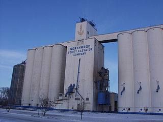
Northwood is a city in Grand Forks County, North Dakota, United States. It is part of the "Grand Forks, ND-MN Metropolitan Statistical Area" or "Greater Grand Forks." The population was 982 at the 2020 census.

<span class="mw-page-title-main">Thompson, North Dakota</span> City in North Dakota, United States

Thompson is a city in Grand Forks County, North Dakota, United States. It is part of the "Grand Forks, ND-MN Metropolitan Statistical Area" or "Greater Grand Forks". It is located on the border of Allendale and Walle townships, with Walle on the east and Allendale on the west. The population was 1,101 at the 2020 census. Thompson was founded in 1881.

<span class="mw-page-title-main">Lakota, North Dakota</span> City in North Dakota, United States

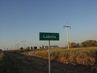
Lakota is a city in Nelson County, North Dakota, United States. It is the county seat of Nelson County Lakota is located 63 miles west of Grand Forks and 27 miles east of Devils Lake. The population was 683 at the 2020 census, making Lakota the 75th-largest city in North Dakota.

<span class="mw-page-title-main">Sand Fork, West Virginia</span> Town in West Virginia, United States

Sand Fork is a town in Gilmer County, West Virginia, United States. The population was 182 at the 2020 census. It is located along the Little Kanawha River, at the mouth of the Sand Fork.

<span class="mw-page-title-main">Worthington, West Virginia</span> Town in West Virginia, United States

Worthington is a town in Marion County, West Virginia, United States. The population was 158 at the 2010 census. Worthington was incorporated in 1893 and named for Colonel George Worthington, an early settler. U.S. Route 19 passes through the town.

<span class="mw-page-title-main">Northfork, West Virginia</span> Town in West Virginia, United States

Northfork is a town in McDowell County, West Virginia, United States, located on U.S. Route 52 between Welch and Bluefield.

<span class="mw-page-title-main">War, West Virginia</span> City in West Virginia, United States

War is a city in McDowell County, West Virginia, United States. The population was 690 at the 2020 census. War was incorporated in 1920 by the Circuit Court of McDowell County. Its name is derived from War Creek, whose confluence with Dry Fork is located within the city. War is the only place in the United States with this name. War was formerly known as Miner's City. It is also known for being a setting in the movie October Sky; as writer Homer Hickam's Big Creek High School.

<span class="mw-page-title-main">Hambleton, West Virginia</span> Town in West Virginia, United States

Hambleton is a town in Tucker County, West Virginia, United States. The population was 216 at the 2020 census. Hambleton was established in 1889, but not incorporated until 1905. It was named by then United States Senator Stephen B. Elkins in honor of a stockholder by this name in the West Virginia Central Railroad Company. The town was previously known as Hulings.

<span class="mw-page-title-main">Paden City, West Virginia</span> City in West Virginia, United States

Paden City is a city in Tyler and Wetzel counties in the U.S. state of West Virginia, along the Ohio River. It was founded in 1902. The population was 2,550 at the 2020 census.

References

  1. "ArcGIS REST Services Directory". United States Census Bureau. Retrieved September 20, 2022.
  2. 1 2 U.S. Geological Survey Geographic Names Information System: Reynolds, North Dakota
  3. 1 2 3 "Explore Census Data". United States Census Bureau . Retrieved October 20, 2023.
  4. 1 2 "City and Town Population Totals: 2020-2022". United States Census Bureau. October 20, 2023. Retrieved October 20, 2023.
  5. Federal Writers' Project (1938). North Dakota, a Guide to the Northern Prairie State. WPA. p. 191. ISBN   978-1-62376-033-5.
  6. "US Gazetteer files 2010". United States Census Bureau. Archived from the original on January 25, 2012. Retrieved June 14, 2012.
  7. United States Census Bureau. "Census of Population and Housing" . Retrieved July 20, 2013.
  8. "Rudolph H. Gjelsness papers 1919-1968 Biography". www.quod.lib.umich.edu. Bentley Historical Library. Retrieved December 31, 2015.
  9. Minnesota Legislators: Past & Present-Reuben Harold Tweten