
Deer Grove is a village in Whiteside County, Illinois, United States. The population was given as 45 in the 2010 census, down from 48 in 2000.

Climax is a city in Greenwood County, Kansas, United States. As of the 2020 census, the population of the city was 45.

Orient is a town in Aroostook County, Maine, United States. The population was 156 at the 2020 census.

Watertown is a small city in Carver County, Minnesota, United States, along the South Fork of the Crow River, on the outskirts of the Twin Cities metro area. The population was 4,659 at the 2020 census.
Backus is a city in Cass County, Minnesota, United States. The population was 262 at the 2020 census. It is part of the Brainerd Micropolitan Statistical Area.

Lake Shore is a city in Cass County, Minnesota, United States. The population was 1,056 at the 2020 census. It is part of the Brainerd Micropolitan Statistical Area.

Hitterdal is a city in Clay County, Minnesota, United States. The population was 199 at the 2020 census.

Deerwood is a city in Crow Wing County, Minnesota, United States. The population was 526 at the 2020 census. It is part of the Brainerd Micropolitan Statistical Area.

La Prairie is a city in Itasca County, Minnesota, United States. The population was 653 at the 2020 census.
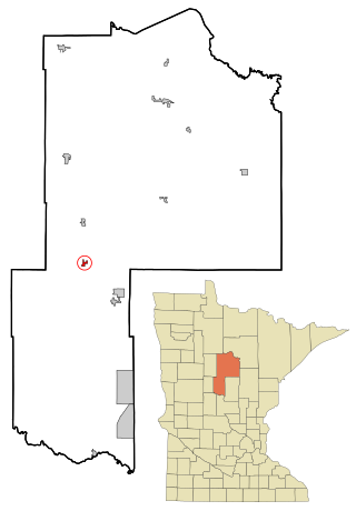
Oslo is a city in Marshall County, Minnesota, United States. The population was 239 at the 2020 census.

Bluffton is a city in Otter Tail County, Minnesota, United States, along the Leaf River. The population was 210 at the 2020 census.

Deer Creek is a city in Otter Tail County, Minnesota, United States. The population was 330 at the 2020 census.

Henning is a city in Otter Tail County, Minnesota, United States. The population was 854 at the 2020 census.

Hoyt Lakes is a city in Saint Louis County, Minnesota. The population was 2,020 at the time of the 2020 census.

McKinley is a city in Saint Louis County, Minnesota, United States; located within the Iron Range region of Minnesota. The population was 103 at the 2020 census.

Dellwood is a city in Washington County, Minnesota, United States and a suburb of St. Paul. The population was 1,063 at the 2010 census.

Grant is a city in Washington County, Minnesota, and a suburb of St. Paul. The population was 4,096 at the time of the 2010 census.

Minnesota Lake is a city in Blue Earth and Faribault counties in the State of Minnesota. The population was 661 at the 2020 census. The bulk of the city is in Faribault County; a small part extends into Blue Earth County.

Eden Valley is a city in Meeker and Stearns counties in the U.S. state of Minnesota. The population was 1,027 at the 2020 census. Most of Eden Valley is in Meeker County; the Stearns County portion is part of the St. Cloud Metropolitan Statistical Area.

Adams is a city in Adams County in the U.S. state of Wisconsin. The population was 1,761 at the 2020 census. The city is located within the Town of Adams.


