Columbia Township, Polk County, Minnesota

Last updated

Columbia Township, Minnesota
USA Minnesota location map.svg
Red pog.svg
Columbia Township, Minnesota
Location within the state of Minnesota
Usa edcp location map.svg
Red pog.svg
Columbia Township, Minnesota
Columbia Township, Minnesota (the United States)
Coordinates: 47°31′41″N95°38′22″W / 47.52806°N 95.63944°W / 47.52806; -95.63944
Country United States
State Minnesota
County Polk
Area
  Total35.7 sq mi (92.6 km2)
  Land34.5 sq mi (89.3 km2)
  Water1.3 sq mi (3.2 km2)
Elevation
1,437 ft (438 m)
Population
 (2000)
  Total429
  Density12.4/sq mi (4.8/km2)
Time zone UTC-6 (Central (CST))
  Summer (DST) UTC-5 (CDT)
FIPS code 27-12682 [1]
GNIS feature ID0663851 [2]

Columbia Township is a township in Polk County, Minnesota, United States. It is part of the Grand Forks-ND-MN Metropolitan Statistical Area. The population was 429 at the 2000 census.

Contents

Geography

According to the United States Census Bureau, the township has a total area of 35.7 square miles (92 km2), of which 34.5 square miles (89 km2) is land and 1.2 square miles (3.1 km2) (3.50%) is water.

Demographics

As of the census [1] of 2000, there were 429 people, 165 households, and 124 families residing in the township. The population density was 12.4 inhabitants per square mile (4.8/km2). There were 203 housing units at an average density of 5.9 per square mile (2.3/km2). The racial makeup of the township was 98.60% White, 0.47% Native American, 0.23% Asian, and 0.70% from two or more races.

There were 165 households, out of which 35.2% had children under the age of 18 living with them, 64.2% were married couples living together, 6.7% had a female householder with no husband present, and 24.8% were non-families. 23.6% of all households were made up of individuals, and 13.3% had someone living alone who was 65 years of age or older. The average household size was 2.60 and the average family size was 3.06.

In the township the population was spread out, with 26.8% under the age of 18, 7.2% from 18 to 24, 23.5% from 25 to 44, 26.6% from 45 to 64, and 15.9% who were 65 years of age or older. The median age was 40 years. For every 100 females, there were 89.0 males. For every 100 females age 18 and over, there were 93.8 males.

The median income for a household in the township was $26,827, and the median income for a family was $35,000. Males had a median income of $30,000 versus $16,944 for females. The per capita income for the township was $12,870. About 8.5% of families and 6.3% of the population were below the poverty line, including 4.0% of those under age 18 and 14.5% of those age 65 or over.

Related Research Articles

<span class="mw-page-title-main">Stilesville, Indiana</span> Town in Indiana, United States

Stilesville is a town in Franklin Township, Hendricks County, Indiana, United States. The population was 316 at the 2010 Census.

<span class="mw-page-title-main">Dansville, Michigan</span> Village in Michigan, United States

Dansville is a village in Ingham County in the U.S. state of Michigan. It is centered along M-36 within Ingham Township about 22 miles (35 km) southeast of downtown Lansing. The population was 563 at the 2010 census.

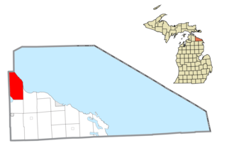
Benona Township is a civil township of Oceana County in the U.S. state of Michigan. As of the 2020 census, the township population was 1,425.

<span class="mw-page-title-main">Bearinger Township, Michigan</span> Civil township in Michigan, United States

Bearinger Township is a civil township of Presque Isle County in the U.S. state of Michigan. As of the 2010 census, the township population was 369.

Waukenabo Township is a township in Aitkin County, Minnesota, United States. The population was 316 as of the 2010 census.

Greenvale Township is a township in Dakota County, Minnesota, United States. The population was 684 at the 2000 census.

Hampton Township is a township in Dakota County, Minnesota, United States. The population was 986 at the 2000 census.

Blue Earth City Township is a township in Faribault County, Minnesota, United States. The population was 454 at the 2000 census.

Brownsville Township is a township in Houston County, Minnesota, United States. The population was 462 at the 2000 census.

Hart Lake Township is a township in Hubbard County, Minnesota, United States. The population was 466 at the 2000 census.

Hillman Township is a township in Kanabec County, Minnesota, United States. The population was 384 at the 2000 census.

Colfax Township is a township in Kandiyohi County, Minnesota, United States. The population was 557 at the 2000 census.

Oak Park Township is a township in Marshall County, Minnesota, United States. The population was 165 as of the 2000 census.

Culdrum Township is a township in Morrison County, Minnesota, United States. The population was 505 at the 2000 census.

Belgrade Township is a township in Nicollet County, Minnesota, United States. The population was 1,033 at the 2000 census.

Eyota Township is a township in Olmsted County, Minnesota, United States. The population was 448 at the 2000 census.

Cannon City Township is a township in Rice County, Minnesota, United States. The population was 1,212 at the 2000 census.

<span class="mw-page-title-main">Rothsville, Pennsylvania</span> Census-designated place in Pennsylvania, United States

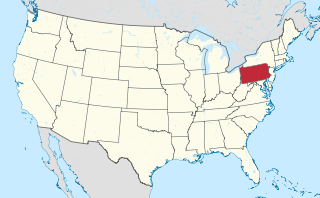
Rothsville is an unincorporated community and census-designated place (CDP) in Warwick Township, Lancaster County, Pennsylvania, United States. The population was 3,044 at the 2010 census. Lititz is the town for residents' mailing addresses.

<span class="mw-page-title-main">Meshoppen Township, Wyoming County, Pennsylvania</span> Township in Pennsylvania, United States

Meshoppen Township is a township in Wyoming County, Pennsylvania, United States. The population was 935 at the 2020 census.

Lennon is a village in the U.S. state of Michigan. The population was 511 at the 2010 census. The village is located along M-13 within Venice Township in Shiawassee County to the west and Clayton Township in Genesee County to the east.

References

  1. 1 2 "U.S. Census website". United States Census Bureau . Retrieved January 31, 2008.
  2. "US Board on Geographic Names". United States Geological Survey. October 25, 2007. Retrieved January 31, 2008.