
Issaquena County is a county located in the U.S. state of Mississippi. As of the 2020 Census, its population was 1,338, making it the least populous county in the United States east of the Mississippi River. Its county seat is Mayersville. With a per-capita income of $18,598, Issaquena County is, by that measure, one of the poorest counties in the United States.
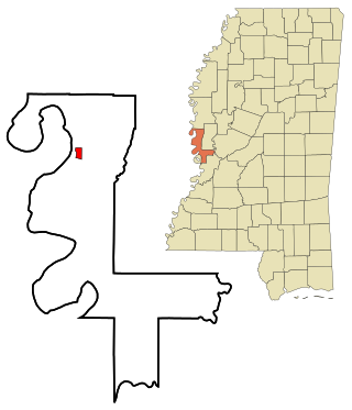
Mayersville is a town on the east bank of the Mississippi River, and the county seat for Issaquena County, Mississippi, United States. It is located in the Mississippi Delta region, known for cotton cultivation in the antebellum era. Once the trading center for the county, the town was superseded when railroads were built into the area. The population of the majority-black town was 547 at the 2010 census, down from 795 at the 2000 census.
Wayside is an unincorporated community in Washington County, Mississippi, United States.
Ben Lomond is an unincorporated community in Mason County, West Virginia, United States. It is located on the eastern bank of the Ohio River at the junction of West Virginia Route 2 and County Route 56,, some 9.7 miles (15.6 km) south-southwest of Point Pleasant.
Baleshed is a ghost town in Issaquena County, Mississippi, United States. Baleshed was located on the Mississippi River.
Arcadia is a ghost town in Issaquena County, Mississippi, United States.
Chotard is an unincorporated community in Issaquena County, Mississippi, United States.
Eutaw is a ghost town in Bolivar County, Mississippi, United States. The settlement had a port on the Mississippi River called "Eutaw Landing."
Duncansby is a ghost town in Issaquena County, Mississippi, United States.
Briers is a ghost town located in Adams County, Mississippi, United States. Briar Landing was its port, located directly on the Mississippi River.
Kienstra is a ghost town located in Adams County, Mississippi, United States. South of the town was Kienstra Landing, located on the Mississippi River.
Artonish is a ghost town located in Wilkinson County, Mississippi, United States. South of the town was Artonish Landing, located on a stretch of the Mississippi River known as the "Homochitto Cutoff".
Australia is a former town located in Bolivar County, Mississippi, United States. Australia was located on the Mississippi River.

Shiloh is a ghost town located in Issaquena County, Mississippi, United States. Shiloh Landing was its port on the Mississippi River.
Magna Vista is a ghost town in Issaquena County, Mississippi.
New Mexico is a ghost town located in present-day Issaquena County, Mississippi, United States. New Mexico became extinct prior to the creation of Issaquena County in 1844, so the settlement existed only within Washington County, Mississippi.
Leota is a ghost town located in Washington County, Mississippi, United States. The settlement, along with its river port Leota Landing, were at one time located directly on the Mississippi River.
Refuge is an unincorporated community located in Washington County, Mississippi, United States.
Pushmataha Landing, also known as Pushmataha, is an unincorporated community located in Coahoma County, Mississippi, United States.

Skipwith's Landing was a 19th-century boat landing and human settlement on the east bank of the Mississippi River, located in the county of Issaquena in the U.S. state of Mississippi. Skipwith's Landing was situated about 55 mi (89 km) to 100 mi (160 km) north of Vicksburg, Mississippi, depending on mode of travel. Circa 1866, a witness at a U.S. Congressional hearing described Skipwith's Landing as being among the most sparsely populated sections of the state with no village or town in proximity. Circa 1867, there were no roads leading to or from Skipwith's Landing; the only access was by the river. For a time there was a cut made by the river that was known as Skipwith's Chute. Another related placename was Skipwith Crevasse. There was a U.S. post office at Skipwith's in 1870.


