Bendon, Michigan

Last updated

Bendon, Michigan
Bendon, MI location.png
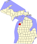
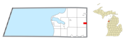
Location within Benzie County
USA Michigan location map.svg
Red pog.svg
Bendon
Location within the state of Michigan
Usa edcp location map.svg
Red pog.svg
Bendon
Bendon (the United States)
Coordinates: 44°37′59″N85°50′16″W / 44.63306°N 85.83778°W / 44.63306; -85.83778
Country United States
State Michigan
County Benzie
Township Inland
Area
[1]
  Total2.00 sq mi (5.19 km2)
  Land2.00 sq mi (5.19 km2)
  Water0.00 sq mi (0.00 km2)
Elevation
846 ft (258 m)
Population
 (2020)
  Total210
  Density104.74/sq mi (40.45/km2)
Time zone UTC-5 (Eastern (EST))
  Summer (DST) UTC-4 (EDT)
ZIP code(s)
49643 (Interlochen)
Area code 231
FIPS code 26-07220 [2]
GNIS feature ID0621089 [3]

Bendon is an unincorporated community and census-designated place in Benzie County in the U.S. State of Michigan. The population was 210 at the 2020 census. [4] Bendon is located within Inland Township.

Contents

Geography

Bendon is located in the eastern part of Inland Township in eastern Benzie County. Bendon's eastern border is the Grand Traverse County line. The center of the community is at the intersection of Bendon Road and Cinder Road.

According to the United States Census Bureau, the Bendon CDP has a total area of 2.0 square miles (5.2 km2), all land. [5]

History

The settlement developed around a sawmill and was first named "Kentville" after Albert Kent, a farmer who became the first postmaster on April 24, 1888. It was given a station on the now abandoned Chicago and West Michigan Railway. The post office was renamed "Bendon" on June 30, 1892, and operated until March 31, 1954. [6] [7]

The community of Bendon was listed as a newly organized census-designated place for the 2010 census, meaning it now has officially defined boundaries and population statistics for the first time. [8]

Demographics

Historical population
CensusPop.Note
2010 208
2020 2101.0%
U.S. Decennial Census [9]

Related Research Articles

<span class="mw-page-title-main">Inland Township, Michigan</span> Civil township in Michigan, United States

Inland Township is a civil township of Benzie County in the U.S. state of Michigan. The population was 2,386 at the 2020 census. The township is located in the east of the county, and shares a border with Grand Traverse County. The Platte River flows through the north of the township.

<span class="mw-page-title-main">Bay Shore, Michigan</span> Census-designated place & unincorporated community in Michigan, United States

Bay Shore is an unincorporated community and census-designated place (CDP) located on the boundary between Charlevoix County and Emmet County in the U.S. state of Michigan. The population of the CDP was 657 at the 2020 census.

<span class="mw-page-title-main">Bergland, Michigan</span> Census-designated place & unincorporated community in Michigan, United States

Bergland is a census-designated place (CDP) and the primary community in Bergland Township, Ontonagon County, Michigan, United States. It is situated on the north shore of Lake Gogebic, the largest natural inland lake on the Upper Peninsula of Michigan. Highway M-28 passes through the center of town, leading east 19 miles (31 km) to Bruce Crossing and southwest 20 miles (32 km) to Wakefield. M-64 leads north from Bergland 17 miles (27 km) to the shore of Lake Superior and 30 miles (48 km) to Ontonagon, the county seat. Bergland is bordered to the west by the Lake Gogebic CDP.

<span class="mw-page-title-main">Carp Lake, Michigan</span> Census-designated place & unincorporated community in Michigan, United States

Carp Lake is an unincorporated community and census-designated place (CDP) in Emmet County in the U.S. state of Michigan. As of the 2010 census, the CDP had a population of 357. It is located within Carp Lake Township.

<span class="mw-page-title-main">Levering, Michigan</span> Census-designated place & unincorporated community in Michigan, United States

Levering is an unincorporated community and census-designated place (CDP) in Emmet County in the U.S. state of Michigan. As of the 2010 census, the CDP had a population of 215.

<span class="mw-page-title-main">Brutus, Michigan</span> Census-designated place & unincorporated community in Michigan, United States

Brutus is an unincorporated community and census-designated place (CDP) in Emmet County in the U.S. state of Michigan. As of the 2010 census, the CDP had a population of 218. Brutus is located within Maple River Township.

<span class="mw-page-title-main">Haring, Michigan</span> Census-designated place & unincorporated community in Michigan, United States

Haring is an unincorporated community and census-designated place (CDP) in Wexford County in the U.S. state of Michigan. The population of the CDP was 335 as of the 2020 census. Haring is located within Haring Charter Township just north of the city of Cadillac.

<span class="mw-page-title-main">Eastport, Michigan</span> Census-designated place & unincorporated community in Michigan, United States

Eastport is an unincorporated community and census-designated place (CDP) located in Antrim County in the U.S. state of Michigan. The population of the CDP was 206 at the 2020 census. It is located in Torch Lake Township, and lies on an isthmus between Torch Lake and Grand Traverse Bay.

<span class="mw-page-title-main">Crystal Downs Country Club, Michigan</span> Census-designated place & unincorporated community in Michigan, United States

Crystal Downs Country Club is a private country club and unincorporated community in Benzie County in the U.S. state of Michigan. The community is located within Lake Township on the shores of Lake Michigan. For statistical purposes, the United States Census Bureau defined the community as a census-designated place for the first time for the 2010 census. At the census, the CDP had a population of 47 and a total land area of 1.26 square miles (3.3 km2).

<span class="mw-page-title-main">Ponshewaing, Michigan</span> Census-designated place & unincorporated community in Michigan, United States

Ponshewaing is an unincorporated community and census-designated place (CDP) in Emmet County in the U.S. state of Michigan. As of the 2010 census, the CDP had a population of 69. It is located within Littlefield Township.

<span class="mw-page-title-main">Oden, Michigan</span> Census-designated place & unincorporated community in Michigan, United States

Oden is an unincorporated community and census-designated place (CDP) in Emmet County in the U.S. state of Michigan. As of the 2010 census, the CDP had a population of 363. It is located within Littlefield Township.

<span class="mw-page-title-main">Conway, Michigan</span> Census-designated place & unincorporated community in Michigan, United States

Conway is an unincorporated community and census-designated place (CDP) in Emmet County in the U.S. state of Michigan. As of the 2010 census, the CDP had a population of 204.

<span class="mw-page-title-main">Crystal Mountain, Michigan</span> Census-designated place & unincorporated community in Michigan, United States

Crystal Mountain is an unincorporated community and census-designated place in Benzie County in the U.S. state of Michigan. The population was 59 at the 2020 census. Crystal Mountain is located within Weldon Township.

<span class="mw-page-title-main">Jennings, Michigan</span> Census-designated place & unincorporated community in Michigan, United States

Jennings is an unincorporated community and census-designated place (CDP) in Missaukee County in the U.S. state of Michigan. The population was 229 at the 2020 census, down from 264 in 2010. The CDP is located mostly in Lake Township with a small portion extending north into Caldwell Township.

<span class="mw-page-title-main">Lakes of the North, Michigan</span> Census-designated place & unincorporated community Association in Michigan, United States

Lakes of the North is an unincorporated community and census-designated place (CDP) in Antrim County in the U.S. state of Michigan. The CDP is located in Mancelona Township to the south and Star Township to the north. The population of the CDP was 1,044 at the 2020 census.

<span class="mw-page-title-main">Hardwood Acres, Michigan</span> Census-designated place & unincorporated community in Michigan, United States

Hardwood Acres is an unincorporated community and census-designated place in Benzie County in the U.S. state of Michigan. The population was 393 at the 2020 census. Hardwood Acres is located within Almira Township.

<span class="mw-page-title-main">Maple Grove, Benzie County, Michigan</span> Census-designated place & unincorporated community in Michigan, United States

Maple Grove is an unincorporated community and census-designated place in Benzie County in the U.S. state of Michigan. The population was 139 at the 2020 census. Maple Grove is located within Almira Township.

<span class="mw-page-title-main">Nessen City, Michigan</span> Census-designated place & unincorporated community in Michigan, United States

Nessen City is an unincorporated community and census-designated place in Benzie County in the U.S. state of Michigan. The population was 81 at the 2020 census. Nessen City is located within Colfax Township.

<span class="mw-page-title-main">Pilgrim, Michigan</span> Census-designated place & unincorporated community in Michigan, United States

Pilgrim is an unincorporated community and census-designated place (CDP) in Benzie County in the U.S. state of Michigan. As of the 2020 census, the CDP had a permanent population of 44. Pilgrim is located within Crystal Lake Township.

<span class="mw-page-title-main">Lake Victoria, Michigan</span> Census-designated place & unincorporated community in Michigan, United States

Lake Victoria is an unincorporated community and census-designated place (CDP) in Clinton County in the U.S. state of Michigan. It is located in Victor Township. As of the 2010 census, it had a population of 930.

References

  1. "2020 U.S. Gazetteer Files". United States Census Bureau. Retrieved May 21, 2022.
  2. "U.S. Census website". United States Census Bureau . Retrieved January 31, 2008.
  3. U.S. Geological Survey Geographic Names Information System: Bendon, Michigan
  4. "Bendon CPD, Michigan - Census Bureau Profile". United States Census Bureau. Retrieved March 5, 2024.
  5. "Geographic Identifiers: 2010 Demographic Profile Data (G001): Bendon CDP, Michigan". U.S. Census Bureau, American Factfinder. Archived from the original on February 12, 2020. Retrieved December 31, 2013.
  6. Romig, Walter (1986) [1973]. Michigan Place Names. Detroit, Michigan: Wayne State University Press. ISBN   0-8143-1838-X.
  7. U.S. Geological Survey Geographic Names Information System: Bendon Post Office (historical)
  8. "Michigan: 2010 Population and Housing Unit Counts 2010 Census of Population and Housing" (PDF). 2010 United States Census . United States Census Bureau. September 2012. p. III-4. Retrieved August 8, 2016.
  9. "Census of Population and Housing". Census.gov. Retrieved June 4, 2016.