Honor, Michigan

Last updated

Honor, Michigan
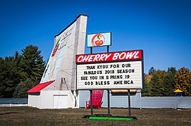
Cherry Bowl Drive-In Movie Theater.jpg
The Cherry Bowl located in Honor
Honor (village), MI location.png
Location within Benzie County
USA Michigan location map.svg
Red pog.svg
Honor
Location within the state of Michigan
Coordinates: 44°39′56″N86°01′20″W / 44.66556°N 86.02222°W / 44.66556; -86.02222
Country Flag of the United States.svg United States
State Flag of Michigan.svg  Michigan
County Benzie
Township Homestead
Area
[1]
  Total0.55 sq mi (1.43 km2)
  Land0.54 sq mi (1.40 km2)
  Water0.01 sq mi (0.04 km2)
Elevation
643 ft (196 m)
Population
 (2020)
  Total337
  Density625.23/sq mi (241.31/km2)
Time zone UTC-5 (Eastern (EST))
  Summer (DST) UTC-4 (EDT)
ZIP code(s)
49640
Area code 231
FIPS code 26-39080 [2]
GNIS feature ID0628533 [3]

Honor is a village in Benzie County of the U.S. state of Michigan. The population was 337 at the 2020 census. The village is located within Homestead Township on U.S. Highway 31 along the Platte River.

Contents

The community has the name of Honor Griffin, the daughter of a first settler. [4]

Geography

According to the United States Census Bureau, the village has a total area of 0.56 square miles (1.45 km2), of which 0.54 square miles (1.40 km2) is land and 0.02 square miles (0.05 km2) is water. [5]

Demographics

Historical population
CensusPop.Note
1920 239
1930 2546.3%
1940 28411.8%
1950 269−5.3%
1960 2783.3%
1970 2821.4%
1980 281−0.4%
1990 2923.9%
2000 2992.4%
2010 3289.7%
2020 3372.7%
U.S. Decennial Census [6]

2010 census

As of the census [7] of 2010, there were 328 people, 135 households, and 87 families residing in the village. The population density was 607.4 inhabitants per square mile (234.5/km2). There were 186 housing units at an average density of 344.4 per square mile (133.0/km2). The racial makeup of the village was 93.0% White, 0.3% African American, 2.4% Native American, 0.3% Asian, and 4.0% from two or more races. Hispanic or Latino of any race were 2.4% of the population.

There were 135 households, of which 30.4% had children under the age of 18 living with them, 43.0% were married couples living together, 13.3% had a female householder with no husband present, 8.1% had a male householder with no wife present, and 35.6% were non-families. 30.4% of all households were made up of individuals, and 18.5% had someone living alone who was 65 years of age or older. The average household size was 2.43 and the average family size was 2.99.

The median age in the village was 38 years. 26.5% of residents were under the age of 18; 8.2% were between the ages of 18 and 24; 22.3% were from 25 to 44; 22.6% were from 45 to 64; and 20.4% were 65 years of age or older. The gender makeup of the village was 47.6% male and 52.4% female.

2000 census

As of the census [2] of 2000, there were 299 people, 129 households, and 82 families residing in the village. The population density was 543.1 inhabitants per square mile (209.7/km2). There were 153 housing units at an average density of 277.9 per square mile (107.3/km2). The racial makeup of the village was 86.29% White, 6.02% Native American, 0.67% Asian, 3.01% from other races, and 4.01% from two or more races. Hispanic or Latino of any race were 3.34% of the population.

There were 129 households, out of which 27.9% had children under the age of 18 living with them, 45.7% were married couples living together, 10.9% had a female householder with no husband present, and 36.4% were non-families. 29.5% of all households were made up of individuals, and 18.6% had someone living alone who was 65 years of age or older. The average household size was 2.32 and the average family size was 2.80.

In the village, the population was spread out, with 24.4% under the age of 18, 9.0% from 18 to 24, 26.4% from 25 to 44, 22.1% from 45 to 64, and 18.1% who were 65 years of age or older. The median age was 38 years. For every 100 females, there were 100.7 males. For every 100 females age 18 and over, there were 91.5 males.

The median income for a household in the village was $32,917, and the median income for a family was $40,833. Males had a median income of $22,273 versus $18,750 for females. The per capita income for the village was $14,274. About 4.1% of families and 11.9% of the population were below the poverty line, including 14.0% of those under the age of eighteen and 3.9% of those 65 or over.
Arts and culture

Honor hosts the Coho Festival during the month of August in celebration of the area's most important fish, the coho salmon.

Honor also has the only drive-in theater left in central Michigan; [8] the Cherry Bowl Diner is located in Honor on U.S. 31.

Related Research Articles

<span class="mw-page-title-main">San Geronimo, California</span> Census-designated place in California, United States

San Geronimo is a census-designated place (CDP) located in the San Geronimo Valley in Marin County, California in the United States. San Geronimo is bordered by Lagunitas-Forest Knolls to its west and Woodacre to its east. It is 8 miles (13 km) southwest of downtown Novato at an elevation of 292 feet (89 m). The population was 510 at the 2020 census.

<span class="mw-page-title-main">Twain, California</span> Census-designated place in California, United States

Twain is a census-designated place (CDP) in Plumas County, California, United States. As of the 2020 census, the CDP population was 303, up from 82 at the 2010 census.

<span class="mw-page-title-main">Grand Ridge, Florida</span> Town in Florida, United States

Grand Ridge is a town in Jackson County, Florida, United States. It is part of the Florida Panhandle and North Florida. The population was 882 at the 2020 census.

<span class="mw-page-title-main">Monroe, Maine</span> Town in the state of Maine, United States

Monroe is a town in Waldo County, Maine, United States named for President James Monroe. The population was 931 at the 2020 census.

<span class="mw-page-title-main">Dennis Port, Massachusetts</span> Census-designated place in Massachusetts, United States

Dennis Port is a census-designated place (CDP) in the town of Dennis in Barnstable County, Cape Cod, Massachusetts, United States. At the 2010 census, its population was 3,162.

Leighton Township is a civil township of Allegan County in the U.S. state of Michigan. The population was 7,001 at the 2020 census, up from 4,934 at the 2010 census.

<span class="mw-page-title-main">Carlton, Minnesota</span> City in Minnesota, United States

Carlton is a city in Carlton County, Minnesota, United States. The population was 948 at the 2020 census. It is the county seat of Carlton County. The town sits on the northwestern edge of Jay Cooke State Park.

<span class="mw-page-title-main">Dwight, Nebraska</span> Village in Nebraska, United States

Dwight is a village in Butler County, Nebraska, United States. The population was 204 at the 2010 census.

Lemmon Valley–Golden Valley is a former census-designated place (CDP) in Washoe County, Nevada, United States. For the 2010 census it was replaced by two separate CDPs, Lemmon Valley and Golden Valley. The population of the combined CDP was 6,855 at the 2000 census. The area is a northern suburb of the city of Reno and is part of the Reno–Sparks Metropolitan Statistical Area.

<span class="mw-page-title-main">Lyons, Ohio</span> Village in Ohio, United States

Lyons is a village in Fulton County, Ohio, United States. The population was 602 at the 2020 census.

<span class="mw-page-title-main">Leipsic, Ohio</span> Village in Ohio, United States

Leipsic is a village in Putnam County, Ohio, United States. The population was 2,177 at the 2020 census.

<span class="mw-page-title-main">Petrolia, Pennsylvania</span> Borough in Pennsylvania, United States

Petrolia is a borough in Butler County, Pennsylvania, United States. The population was 212 at the 2010 census.

<span class="mw-page-title-main">Vanderbilt, Pennsylvania</span> Borough in Pennsylvania, United States

Vanderbilt is a borough in Fayette County, Pennsylvania, United States. The population was 414 at the 2020 census, a decline from the figure of 476 tabulated in 2010. The town is named for the railroad tycoon Cornelius Vanderbilt and is served by the Connellsville Area School District.

<span class="mw-page-title-main">Iva, South Carolina</span> Town in South Carolina, United States

Iva is a town in Anderson County, South Carolina. The population was 1,015 at the 2020 census.

<span class="mw-page-title-main">Wheeler, Wisconsin</span> Village in Wisconsin, United States

Wheeler is a village in Dunn County, Wisconsin, United States, along the Hay River. The population was 348 at the 2010 census.

<span class="mw-page-title-main">Big Falls, Waupaca County, Wisconsin</span> Village in Wisconsin, United States

Big Falls is a village in Waupaca County, Wisconsin, United States. The population was 61 at the 2010 census.

<span class="mw-page-title-main">Ethete, Wyoming</span> CDP in Wyoming, United States

Ethete is a census-designated place (CDP) in Fremont County, Wyoming, United States. The population was 1,553 at the 2010 census. The town is located on the Wind River Indian Reservation. It grew up around the Episcopal St. Michael's Mission.

<span class="mw-page-title-main">Reliance, Wyoming</span> CDP in Wyoming, United States

Reliance is a census-designated place (CDP) in Sweetwater County, Wyoming, United States. The population was 714 at the 2010 census.

<span class="mw-page-title-main">Gratiot, Ohio</span> Village in Ohio, United States

Gratiot is a village in Licking and Muskingum counties in the U.S. state of Ohio. The population was 215 at the 2020 census.

<span class="mw-page-title-main">De Soto, Wisconsin</span> Village in Wisconsin, United States

De Soto is a village mostly in Vernon County but also in Crawford County in Wisconsin, United States. The population was 287 at the 2010 census. Of this, 179 were in living in Vernon County, and 108 were living in Crawford County. The downtown and business area is located in Crawford County.

References

  1. "2020 U.S. Gazetteer Files". United States Census Bureau. Retrieved May 21, 2022.
  2. 1 2 "U.S. Census website". United States Census Bureau . Retrieved January 31, 2008.
  3. "US Board on Geographic Names". United States Geological Survey. October 25, 2007. Retrieved January 31, 2008.
  4. Moyer, Armond; Moyer, Winifred (1958). The origins of unusual place-names. Keystone Pub. Associates. p. 64.
  5. "US Gazetteer files 2010". United States Census Bureau. Archived from the original on January 25, 2012. Retrieved November 25, 2012.
  6. "Census of Population and Housing". Census.gov. Retrieved June 4, 2015.
  7. "U.S. Census website". United States Census Bureau . Retrieved November 25, 2012.
  8. "Cherry Bowl Drive In Theatre in Honor Michigan". Cherry Bowl Drive In Theatre.

44°39′50″N86°01′05″W / 44.66389°N 86.01806°W / 44.66389; -86.01806