Related Research Articles

Marramarra National Park is a protected national park that is located in the Hawkesbury region of northwestern Sydney, New South Wales, in eastern Australia. The 11,785-hectare (29,120-acre) national park is situated approximately 40 kilometres (25 mi) northwest of the Sydney central business district.

The Hills Shire is a local government area in the Greater Sydney region of Sydney, New South Wales, Australia. The suburb is north-west of the Sydney central business district, and encompasses 401 square kilometres (155 sq mi) stretching from the M2 Hills Motorway in the south to Wiseman's Ferry on the Hawkesbury River in the north. The Hills Shire had a population of 157,243 as at the 2016 census.

Hornsby Shire is a local government area situated in Northern Sydney, as well as parts of the Hills District, in the state of New South Wales, Australia. The shire stretches from the M2 Hills Motorway in the south to the Hawkesbury River town of Wisemans Ferry, some 53 kilometres (33 mi) to the north, making it the largest local government council in the Greater Sydney Metropolitan region by total area. As of the 2016 census the shire had an estimated population of 142,667.
The Division of Berowra is an Australian electoral division in the state of New South Wales. The Division covers the northern parts of the Greater Sydney area with the local government areas of the Hornsby Shire and the Hills Shire.

Brooklyn is a suburb and the northern most town on the Pacific Highway in Sydney, New South Wales, Australia. Brooklyn is located on the northern outskirts of Sydney and is located in the local government area of the Hornsby Shire with a population of 722 as of the 2016 census. Brooklyn is surrounded by the Muogamarra Nature Reserve and occupies a strip of waterfront along the southern bank of the Hawkesbury River.

The Hills District is a region of Sydney, within the northern part of the Greater Western Sydney region of Sydney, in the state of New South Wales, Australia. Stretching from the M2 Hills Motorway in the south to the Hawkesbury River in the north and Old Windsor Road in the west to Pennant Hills Road and Berowra Creek in the east, its constituent suburbs are located in the local government areas of The Hills Shire, and parts of Hornsby Shire, City of Parramatta and Blacktown City Council.
Canoelands is a suburb of northern Sydney, in the state of New South Wales, Australia. Canoelands is 60 kilometres north of the Sydney central business district, in the local government area of Hornsby Shire and The Hills Shire.
Maroota is a suburb to the north-west of Sydney, New South Wales, Australia. Maroota is located 49 kilometres north-west of the Sydney central business district, in the local government areas of The Hills Shire and Hornsby Shire.
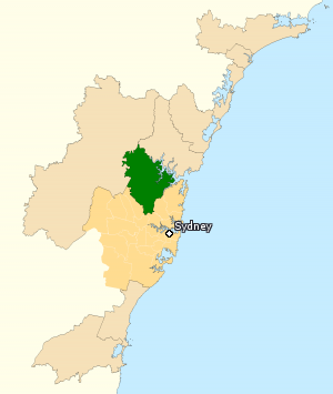
Singletons Mill is a suburb of Sydney, in the state of New South Wales, Australia. It is located in the Hornsby Shire local government area.

Long Island is an elongated island of 73 hectares in the Hawkesbury River, about 50 kilometres (31 mi) north of the Sydney central business district,New South Wales, Australia. It is joined to the mainland at its south eastern edge by the railway causeway across Sandbrook Inlet. At the other end of this causeway is the Sydney suburb of Brooklyn in Hornsby Shire, to which Long Island belongs.

The Berowra Creek, a watercourse that is part of the Hawkesbury-Nepean catchment, is located to the north of the Sydney central business district in the Hornsby Shire of New South Wales, Australia.

A tide mill is a water mill driven by tidal rise and fall. A dam with a sluice is created across a suitable tidal inlet, or a section of river estuary is made into a reservoir. As the tide comes in, it enters the mill pond through a one-way gate, and this gate closes automatically when the tide begins to fall. When the tide is low enough, the stored water can be released to turn a water wheel.
Glenworth Valley is in the Central Coast region to the north of the Hawkesbury River itself 50 km (31 mi) to the north of the city of Sydney, Australia. Popran Creek flows through the valley which includes parts of the suburbs of Glenworth Valley and Mount White. Popran National Park was created in 1994 and is for the most part made up of sandstone cliffs and gullies. The creation of the park is indicative of the value the area has because of its unique indigenous and early European history, fauna, flora and geology. The Park takes its name from Popran Creek which rises in the locality of Central Mangrove and then flows for approximately 24 km (15 mi) in a mostly southern direction till it reaches Mangrove Creek.

Singleton Council is a local government area in the Hunter Region of New South Wales, Australia. It is situated adjacent to the New England Highway and the Main North railway line.

Northern Sydney is a large metropolitan area in Greater Sydney, New South Wales, Australia on the north shore of Sydney Harbour and Parramatta River. The region embraces suburbs in Sydney's north-east, north and inner north west. Northern Sydney is divided into distinctive regions such as the North Shore, Northern Beaches and Forest District.
John Howe (1774–1852) was a free settler and explorer of Australia in the early period of British colonisation. He became a successful building contractor, and also served as a chief constable and coroner. It is believed that he was born at Redbourn, Hertfordshire, England, the son of John How and his spouse Mary Roberts.

The Peats Ferry Bridge is a steel truss bridge that carries the Pacific Highway (B83) across the Hawkesbury River, between Kangaroo Point and Mooney Mooney Point, located 40 kilometres (25 mi) north of Sydney in New South Wales, Australia. The bridge carries the Hornsby to Kariong section of highway, while the adjacent Brooklyn Bridge carries the Pacific Motorway (M1).
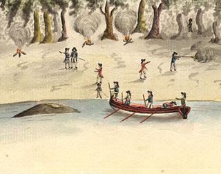
The Hawkesbury and Nepean Wars (1794–1816) were a series of conflicts where British forces, including armed settlers and detachments of the British Army in Australia, fought against Indigenous clans inhabiting the Hawkesbury River region and the surrounding areas to the west of Sydney. The wars began in 1794, when the British started to construct farms along the river, some of which were established by soldiers.
Wambo Homestead is a heritage-listed disused homestead at Warkworth, Singleton Council, New South Wales, Australia. It was built from 1830 to 1906. It was added to the New South Wales State Heritage Register on 2 April 1999.
William Parr was an Australian explorer, known for his roles of mineralogist and cartographer with John Oxley, as expedition leader with Benjamin Singleton, and as trailblazer for the successful expedition by John Howe.
References
- 1 2 3 4 5 Gray, Nancy (1967). "Singleton, Benjamin (1788–1853)". Australian Dictionary of Biography. Retrieved 31 Oct 2019.
- ↑ Dollin, Anne; Dollin, Les (2023). The Singleton Family Flour Mills at Singleton - The Hidden History (PDF). Self-published as PDF eBook.
- ↑ "Singleton's Mill". Hornsby Shire. Retrieved 2023-11-27.
- ↑ "Singleton's Mill, a history". Hornsby Shire. Retrieved 2023-11-27.
- ↑ Gray, Nancy (1966). "Howe, John (1774–1852)". Australian Dictionary of Biography. Retrieved 30 Sep 2019.
- ↑ "Benjamin Singleton 1788-1853". Singleton Council. Retrieved 2 June 2020.