Berneval-le-Grand

Last updated
Berneval-le-Grand
Part of Petit-Caux
Location of Berneval-le-Grand
Berneval-le-Grand
France location map-Regions and departements-2016.svg
Red pog.svg
Berneval-le-Grand
Normandie region location map.svg
Red pog.svg
Berneval-le-Grand
Coordinates: 49°57′32″N1°11′20″E / 49.9589°N 1.1889°E / 49.9589; 1.1889 Coordinates: 49°57′32″N1°11′20″E / 49.9589°N 1.1889°E / 49.9589; 1.1889
Country France
Region Normandy
Department Seine-Maritime
Arrondissement Dieppe
Canton Dieppe-2
Commune Petit-Caux
Area
1
5.56 km2 (2.15 sq mi)
Population
 (2017) [1]
1,409
  Density250/km2 (660/sq mi)
Time zone UTC+01:00 (CET)
  Summer (DST) UTC+02:00 (CEST)
Postal code
76370
Elevation0–110 m (0–361 ft)
(avg. 104 m or 341 ft)
1 French Land Register data, which excludes lakes, ponds, glaciers > 1 km2 (0.386 sq mi or 247 acres) and river estuaries.

Berneval-le-Grand is a former commune in the Seine-Maritime department in the Normandy region in northern France. On 1 January 2016, it was merged into the new commune of Petit-Caux. [2]

Contents

Geography

A farming village in the Pays de Caux, situated on the cliff-lined coast of the English Channel some 5 miles (8.0 km) northeast of Dieppe, at the junction of the D54 and D113 roads.

History

On the morning of 19 August 1942, the beach at Berneval was one of the landing locations of the Anglo-Canadian raid on Dieppe. No. 3 Commando landed on "Yellow 1", the beach of Petit Berneval, but got stuck at the top of the cliffs, unable to fulfil their mission. Most were killed or captured, only one managed to escape by swimming back to the boats. Those who landed on "Yellow 2", at the Fond de Belleville, crossed the fields and attacked the gun emplacements, preventing the German gunners aiming at the beaches of Dieppe where the bulk of the landings took place. They all were able to escape by the same route and return to Newhaven.

Heraldry

Arms of Berneval-le-Grand Blason Berneval-le-Grand.svg
Arms of Berneval-le-Grand
The arms of Berneval-le-Grand are blazoned  :
Azure, a pale lozengy argent and gules, between, in bend 2 garbs of wheat Or, and in bend sinister 2 ships argent.

Population

Historical population of Berneval-le-Grand
Year196219681975198219901999200620112013
Population6416667608939981047116613851422
From the year 1962 on: No double countingresidents of multiple communes (e.g. students and military personnel) are counted only once.

Places of interest

Notable people linked to the commune

See also

Related Research Articles

Seine-Maritime Department of France

Seine-Maritime is a department of France in the Normandy region of northern France. It is situated on the northern coast of France, at the mouth of the Seine, and includes the cities of Rouen and Le Havre. Until 1955 it was named Seine-Inférieure.

Dieppe Subprefecture and commune in Normandy, France

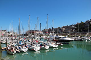
Dieppe is a coastal commune in the Seine-Maritime department in the Normandy region of northern France.

Pays de Caux

The Pays de Caux is an area in Normandy occupying the greater part of the French département of Seine Maritime in Normandy. It is a chalk plateau to the north of the Seine Estuary and extending to the cliffs on the English Channel coast; its coastline is known as the Côte d'Albâtre. In the east, it borders on the Pays de Bray where the strata below the chalk show through.

Le Tréport Commune in Normandy, France

Le Tréport is a commune in the Seine-Maritime department in Normandy, France.

Saint-Valery-en-Caux Commune in Normandy, France

Saint-Valery-en-Caux is a commune in the Seine-Maritime department in the Normandy region in northern France.

Saint-Martin-en-Campagne Part of Petit-Caux in Normandy, France

Saint-Martin-en-Campagne is a former commune in the Seine-Maritime department in the Normandy region in northern France. On 1 January 2016, it was merged into the new commune of Petit-Caux.

Saint-Pierre-en-Port Commune in Normandy, France

Saint-Pierre-en-Port is a commune in the Seine-Maritime department in the Normandy region in northern France.

Tocqueville-sur-Eu Part of Petit-Caux in Normandy, France

Tocqueville-sur-Eu is a former commune in the Seine-Maritime department in the Normandy region in northern France. On 1 January 2016, it was merged into the new commune of Petit-Caux.

Saint-Aubin-sur-Mer, Seine-Maritime Commune in Normandy, France

Saint-Aubin-sur-Mer is a commune in the Seine-Maritime department in the Normandy region in northern France.

Bracquemont Part of Petit-Caux in Normandy, France

Bracquemont is a former commune in the Seine-Maritime department in the Normandy region in northern France. On 1 January 2016, it was merged into the new commune of Petit-Caux.

Biville-sur-Mer Part of Petit-Caux in Normandy, France

Biville-sur-Mer is a former commune in the Seine-Maritime department in the Normandy region in northern France. On 1 January 2016, it was merged into the new commune of Petit-Caux.

Derchigny Part of Petit-Caux in Normandy, France

Derchigny is a former commune in the Seine-Maritime department in the Normandy region in north-western France. On 1 January 2016, it was merged into the new commune of Petit-Caux. The local name is Derchigny-Graincourt as the commune is the reunion of two ancient communes, Derchigny and Graincourt.

Hautot-sur-Mer Commune in Normandy, France

Hautot-sur-Mer is a commune in the Seine-Maritime department in the Normandy region in north-western France.

Varengeville-sur-Mer Commune in Normandy, France

Varengeville-sur-Mer is a commune in the Seine-Maritime department in the Normandy region in north-western France.

Sotteville-sur-Mer Commune in Normandy, France

Sotteville-sur-Mer is a commune in the Seine-Maritime department in the Normandy region in north-western France.

Saint-Sylvain, Seine-Maritime Commune in Normandy, France

Saint-Sylvain is a commune in the Seine-Maritime department in the Normandy region in northern France.

The former Communauté de communes du Petit Caux was created on August 24, 1982 and is located in the Seine-Maritime département of the Normandy region of north-western France. It was disbanded on 1 January 2016 when its member communes merged into the new commune Petit-Caux.

Côte dAlbâtre

The Côte d'Albâtre is part of the French coast of the English Channel, corresponding to the coastline of Pays de Caux and forming almost all of the coastline of Seine-Maritime. Since 2009 it has been classified as a Natura 2000 site. It takes its name from the white hue of its high chalk cliffs, including those of Étretat, which stretch for over 120 km, dominating most of the coastline. It is part of the same geological system as the White Cliffs of Dover on the far side of the English Channel.

Petit-Caux Commune in Normandy, France

Petit-Caux is a commune in the department of Seine-Maritime, northern France. The municipality was established on 1 January 2016 by merger of the 18 former communes of Saint-Martin-en-Campagne, Assigny, Auquemesnil, Belleville-sur-Mer, Berneval-le-Grand, Biville-sur-Mer, Bracquemont, Brunville, Derchigny, Glicourt, Gouchaupre, Greny, Guilmécourt, Intraville, Penly, Saint-Quentin-au-Bosc, Tocqueville-sur-Eu and Tourville-la-Chapelle. These communes previously cooperated in the Communauté de communes du Petit Caux.

The canton of Dieppe-2 is an administrative division of the Seine-Maritime department, in northern France. It was created at the French canton reorganisation which came into effect in March 2015. Its seat is in Dieppe.

References