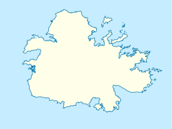
Bethesda, Antigua and Barbuda

Last updated
Bethesda
Village
Bethesda in 2023.jpg
Bethesda in June 2023
Antigua location map.svg
Red pog.svg
Bethesda
Coordinates: 17°03′N61°45′W / 17.050°N 61.750°W / 17.050; -61.750
Country Antigua and Barbuda
Island Antigua
Civil parish Saint Paul
Area
  Total1.62 km2 (0.63 sq mi)
Elevation
12 m (39 ft)
Population
 (2011)
  Total499
  Density308/km2 (800/sq mi)
Time zone UTC-4 (AST)

Bethesda is a village in Saint Paul Parish on the island of Antigua, in Antigua and Barbuda.

Contents

It is located in the southeastern area of the island, to the northeast of English Harbour, at the head of Willoughby Bay.

Geography

Bethesda is found on Willoughby Bay, which is a wide bay on the east coast of the island's southern peninsula. The terrain flattens out and extends inland to the northeast, eventually reaching the Central Plain, which is the island's core plain. The hills of Monks Hill may be found to the southwest, and they border both Falmouth Bay and English Harbour. The region is primarily agricultural and has a low population density.

The settlement, which has a population of exactly 499 people in 2011, may be found along the route that leads from St. Phillip's Parish in the southeastern part of Antigua to English Harbour.

The Bethesda Dam is located in the interior and is the second largest dam in the country, behind the Potworks Dam, which is located around 2 kilometers to the north. One of the largest remaining mangrove stands on the island is located at the Christian Cove wetland, which is located on the shore.

History

The Methodists, who first arrived in Antigua in 1760 and began spreading their religion throughout the island, established a school for the employees of the Blake estate in 1812. [1] It was the very first school in the West Indies to be constructed specifically for enslaved people. [2] The pastoral care center saw an increase in patients following the abolition of slavery in 1834, which led to the establishment of a new location. [3] In the beginning, the congregation and chapel were situated in Bridgetown, which is located on Willoughby Bay. In the year 1841, the mission relocated to Bethesda, which gets its name from the new church in recognition of the Bethesda Garden. [1] Willoughby Bay was a hamlet in Antigua that was abandoned in 1843 after an earthquake. [1] The people who lived there migrated to Freetown, which was at the time the most prominent freed-village on the island of Antigua. [1] Some of them also moved to Bethesda. [1] Even as early as 1847, the church underwent expansion, and in 1871, a new church that also included a school was constructed. [1] The Methodists ran the classes until 1962, when a state school was founded. The current church building, which is a sturdy structure "dedicated to the glory of God," was constructed in 1975. [1]

In addition, Bethesda was a significant player in the development of the early labor movement throughout history. In this location in January of 1951, the workers of the sugar cane industry engaged in a labor dispute with a major landowner named Alexander Moody-Stuart over their wages. Vere Cornwall Bird, who had previously served as the first prime minister of the independent state of Antigua and Barbuda, delivered the speech from which the winged term "to eat mussels and Widdy-Widdy and drink pond water" originates. In the event that there was nothing to eat as a result of the strike, we would sip pond water. At the time of the slaves, there was often excess bread lying around the Bethesda area, and anyone could take it. It has been exactly one year since the workers went on strike and successfully pushed for greater wages. In the shade of the unassuming Tamarind tree, which still stands today but is significant in the annals of the nation's history, the terms were initially developed. [4]

Nowadays, the location is home to a medical facility, an elementary school, and congregations of the Methodist Church in the Caribbean and Americas, [1] the Church of God Antigua (Bethesda Zion Church, which was established in 1951), [5] and the St. John's Pentecostal Church (1950s). [6]

Enumeration districts

Bethesda-East has a population of 291, and is 97.45% Afro-Antiguan, and 0.89 square kilometres. Bethesda-East shares boundaries with Saint Philip Parish. [8] Bethesda-West has a population of 208, and is 94.90% Afro-Antiguan, and 0.73 square kilometres. [8]

Demographics

Census data (2011)

Source: [9]

Q48 EthnicCounts%
African descendent48196.38%
East Indian/India30.64%
Mixed (Black/White)10.21%
Mixed (Other)101.91%
Don't know/Not stated40.85%
Total499100.00%
Q49 ReligionCounts%
Adventist7515.24%
Anglican489.66%
Church of God367.30%
Evangelical112.15%
Jehovah Witness20.43%
Methodist16132.62%
Moravian61.29%
None/no religion51.07%
Pentecostal12525.32%
Rastafarian71.50%
Roman Catholic40.86%
Wesleyan Holiness40.86%
Other10.21%
Don't know/Not stated71.50%
Total494100.00%
NotApp :4
Q53 InsuranceCounts%
Yes29358.72%
No18737.45%
Don't know/Not stated193.83%
Total499100.00%
Q55 Internet UseCounts%
Yes23947.87%
No24448.94%
Don't know/Not stated163.19%
Total499100.00%
Q58. Country of birthCounts%
Other Latin or North American countries10.21%
Antigua and Barbuda43286.60%
Other Caribbean countries10.21%
Canada20.43%
Dominica30.64%
Guyana204.04%
Jamaica40.85%
Monsterrat20.43%
St. Kitts and Nevis20.43%
St. Lucia20.43%
St. Vincent and the Grenadines10.21%
Trinidad and Tobago20.43%
USA173.40%
USVI United States Virgin Islands40.85%
Not Stated40.85%
Total499100.00%
Q71 Country of Citizenship 1Counts%
Antigua and Barbuda47194.47%
Other Caribbean countries10.21%
Dominica10.21%
Guyana132.55%
Jamaica20.43%
Monsterrat10.21%
St. Lucia10.21%
Trinidad and Tobago20.43%
USA10.21%
Other countries10.21%
Not Stated40.85%
Total499100.00%
Q71 Country of Citizenship 2 (Country of Second Citizenship)Counts%
Other Caribbean countries37.89%
Canada37.89%
Dominica25.26%
Guyana718.42%
Jamaica25.26%
Monsterrat12.63%
St. Lucia12.63%
St. Vincent and the Grenadines12.63%
USA1947.37%
Total40100.00%
NotApp :458
Employment statusCounts%
Employed24463.01%
Unemployed236.03%
Inactive11730.14%
Not stated30.82%
Total387100.00%
NotApp :111
Q117 MoneyOverseasCounts%
Under 100 EC$37897.53%
500 to 999 EC$10.27%
1,000 to 1,999 EC$51.37%
2,000 to 4,999 EC$20.55%
5,000 to 99,999 EC$10.27%
Total387100.00%
NotApp :111

Related Research Articles

<span class="mw-page-title-main">Antigua and Barbuda</span> Country in the Lesser Antilles of the West Indies

Antigua and Barbuda is a sovereign island country in the Caribbean. It lies at the conjuncture of the Caribbean Sea and the Atlantic Ocean in the Leeward Islands part of the Lesser Antilles.

<span class="mw-page-title-main">Saint Philip, Antigua and Barbuda</span> Parish in Antigua and Barbuda

Saint Philip, officially the Parish of Saint Philip, is a civil parish of Antigua and Barbuda, on the easternmost portion of Antigua island. Its capital is the village of St. Philip's. Saint Philip borders Saint Peter and Saint Paul. Saint Philip faces the Atlantic Ocean. Saint Philip is surrounded by various islands and islets. It had a population of 3,347 in 2011, which makes it the least populous parish of Antigua and Barbuda.

<span class="mw-page-title-main">Saint Mary, Antigua and Barbuda</span> Parish in Antigua and Barbuda

Saint Mary, officially the Parish of Saint Mary, is a parish of Antigua and Barbuda on the island of Antigua. Saint Mary borders Saint John to the north, and Saint Paul to the east. Saint Mary is dominated by the Shekerley Mountains, and its northern border is largely defined by the mountains, and by Cooks Creek. The largest city in the parish is Bolans, home to the Jolly Harbour neighbourhood, and the parish church is located in Old Road. Saint Mary was created with the other five original parishes on 11 January 1692. It had a population of 7,341 in 2011, and 8,141 in 2018.

<span class="mw-page-title-main">Saint Paul, Antigua and Barbuda</span> Parish in Antigua and Barbuda

Saint Paul, officially the Parish of Saint Paul, is a parish of Antigua and Barbuda on the island of Antigua. Saint Paul borders Saint Peter and Saint John to the north, Saint Mary to the west, and Saint Philip to the east. Saint Paul is dominated by farmland in the north, with various creeks and Potworks Dam marking its northern border, and low-lying hills to the south, defining its western border with Saint Mary. The largest city fully within the parish is Liberta, the fourth largest city in the country. The parish capital, and the location of the parish church, is Falmouth. The main economic and tourism hub of the parish is English Harbour. Saint Paul was created with the other five original parishes on 11 January 1692. It had a population of 9,004 in 2018.

<span class="mw-page-title-main">Saint Peter, Antigua and Barbuda</span> Parish in Antigua and Barbuda

Saint Peter, officially the Parish of Saint Peter, is a parish of Antigua and Barbuda on the island of Antigua. Saint Peter borders Saint Paul to the south, Saint Philip to the east, and Saint George and Saint John to the west. Saint Peter is dominated by farmland, savanna, and undeveloped fields, and its borders are not well-defined. The largest city fully within the parish is Parham, which is also the capital. However, the portion of the city of All Saints in Saint Peter is significantly larger than Parham. Saint Peter was created with the other five original parishes on 11 January 1692. It had a population of 5,325 in 2011.

<span class="mw-page-title-main">Antigua</span> Island in Antigua and Barbuda

Antigua, also known as Waladli or Wadadli by the native population, is an island in the Lesser Antilles. It is one of the Leeward Islands in the Caribbean region and the most populous island of the country of Antigua and Barbuda. Antigua and Barbuda became an independent state within the Commonwealth of Nations on 1 November 1981.

<span class="mw-page-title-main">All Saints, Antigua and Barbuda</span> Village in Antigua, Antigua and Barbuda

All Saints is the second largest settlement in Antigua and Barbuda, with a population of 3,412. It is located in the middle of Antigua, at 17°3′N61°47′W. Just 5 miles NW of here is the capital, St. John's. It had a population of 3,900 in 2001.

<span class="mw-page-title-main">Parham, Antigua and Barbuda</span> Town in Antigua, Antigua and Barbuda

Parham, officially known as the Town of Parham, is the capital of Saint Peter, the largest city in Saint Peter, and the fourteenth largest city in Antigua and Barbuda. Parham had a population of 1,307 in 2011, distributed over 1.99 square kilometres. Parham is similar in population to Potters Village, the thirteenth largest city in Antigua and Barbuda, and Bendals, the fifteenth largest city. Parham is situated on the shore of Parham Harbour, one of the most important harbors in the country enclosed by the Parham Peninsula and Long Island. Parham comprises four main neighbourhoods: Lovers Lane, Parham Market, Byam Wharf, and the School neighborhood. If the Saint Peter portion of All Saints, home to 1,954 people extending across three parishes, is considered a separate city, Parham would be considered the second largest city of Saint Peter. The major division of Parham, the town's metropolitan area, stretching over the eastern portion of the parish, had a 2011 population of 3,499 people.

<span class="mw-page-title-main">Liberta, Antigua and Barbuda</span> Village in Antigua, Antigua and Barbuda

Liberta is a town located in Saint Paul Parish, on the island of Antigua in Antigua and Barbuda. It had a population of 2,560 in 2001.

Freetown, officially known as FreeTown, is a town in Antigua. It is located in the southeast of the island, on a peninsula between Willoughby Bay to the south and Nonsuch Bay to the north.

<span class="mw-page-title-main">Swetes</span> Town in Antigua, Antigua and Barbuda

Swetes is located in Saint Paul Parish on the island of Antigua, in Antigua and Barbuda.

Piggotts, also known as St Mark's Village, is a small township in Saint George Parish on Antigua island in Antigua and Barbuda. It had a population of 1,478 in 2001.

Potworks Dam is in central Antigua located close to Bethesda. One of the most significant water treatment facilities on the island is located on the southern shore at the Delapps Water Treatment Plant.

Sea View Farm is a village located in Saint George Parish on the island of Antigua, in Antigua and Barbuda.

Freemans is a village located in Saint Peter Parish on the island of Antigua, in Antigua and Barbuda.

<span class="mw-page-title-main">Afro-Antiguans and Barbudans</span>

Afro-Antiguans and Afro-Barbudans are Antiguans and Barbudans of entirely or predominantly African ancestry.

<span class="mw-page-title-main">Five Islands, Antigua and Barbuda</span> Village in Antigua, Antigua and Barbuda

Five Islands Village is a village located on the northwest coast of Antigua, within Saint John Parish in Antigua and Barbuda.

<span class="mw-page-title-main">Urlings</span> Village in Antigua, Antigua and Barbuda

Urlings is a village in Saint Mary, and the twenty-sixth largest settlement in Antigua and Barbuda. Urlings is located in the southwest of Antigua and has a history dating to before 1856. Urlings started as a small coastal village with a little over 100 people in the 1800s to now being one of the country's more medium sized towns. Urlings is separated from the rest of Antigua by the Shekerley Mountains. Urlings is located between the communities of Johnsons Point and Old Road. Urlings has a seafood festival, a community association, a primary school, a playing field, a fisheries complex, and a cricket club that plays in the Village Parish League.

<span class="mw-page-title-main">Indian Antiguans and Barbudans</span>

Indian Antiguans and Indian Barbudans are Antiguans and Barbudans of entirely or predominantly Indian descent.

Bridgetown, also known as Willoughby Bay, is a ghost town in Saint Philip, Antigua and Barbuda.

References

  1. 1 2 3 4 5 6 7 8 "Bethesda | Methodist Church of Antigua & Barbuda Bethesda |". 2014-03-20. Archived from the original on 2014-03-20. Retrieved 2023-03-12.
  2. "ANTIGUA & BARBUDA'S CULTURAL HERITAGE". antiguahistory.net. Retrieved 2023-03-12.
  3. Samuel, Hewlester A. (2007). The birth of the village of Liberta, Antigua. Coral Springs, FL: Llumina Press. ISBN   978-1-59526-726-9. OCLC   316028853.
  4. Beale, Christopher (2010). Antiqua & Barbuda : island guide. Washington, D.C.: Other Places. ISBN   978-0-615-21837-3. OCLC   1301799363.
  5. "Church of God Antigua". 2014-03-02. Archived from the original on 2014-03-02. Retrieved 2023-03-12.
  6. "About Us « St. John's Pentecostal Church House Of Restoration Ministries". 2013-12-25. Archived from the original on 2013-12-25. Retrieved 2023-03-12.
  7. 1 2 "Antigua and Barbuda 2001 Census" (PDF). Archived (PDF) from the original on 2014-02-22.
  8. 1 2 "Enumeration District Boundaries for the 2021 Census". nri.environment.gov.ag. Retrieved 2023-03-12.
  9. "Antigua and Barbuda::Statistics Division/Redatam Webserver | Statistical Process and Dissemination Tool". redatam.org. Retrieved 2021-12-23.