Freemans, Antigua and Barbuda

Last updated
Freemans
Village
Freemansville
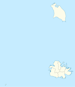
Antigua and Barbuda location map.svg
Red pog.svg
Freemans
Location in Antigua and Barbuda
Coordinates: 17°04′46″N61°47′07″W / 17.07944°N 61.78528°W / 17.07944; -61.78528
Country Antigua and Barbuda
Island Antigua
Civil parish Saint Peter
Area
  Total2.51 km2 (0.97 sq mi)
Population
 (2011)
  Total860
  Density342.6/km2 (887/sq mi)
Time zone UTC-4 (AST)

Freemans is a village located in Saint Peter Parish on the island of Antigua, in Antigua and Barbuda.

Contents

It is located to the southeast of Sea View Farm and northwest of Potworks Dam.

The village claims to be the most central village on Antigua, and is known for producing five centenarians. [1]

Geography

According to legend, "Freeman's Village" would be located right in the middle of the island of Antigua, if one were to map its length and breadth. The majority of the people in that community are convinced that this is an undeniable fact. That desirable designation has received a lot of attention, to the point where greeting signs at the village's entrances now display it. One such sign still stands at the eastern gate and displays the neighborhood's boasting rights. Freeman's Village is brashly referred to as “The Most Central Village In The Island”. [1]

Although some locals assert that Freeman's Village lies exactly in the middle of the island, it is important to keep in mind that it is a small, landlocked community that shares borders with other settlements. A two- or three-degree change can have a significant impact. [1]

History

The idea that the village's name came about as a result of the abolition of slavery is one of the mystiques connected to that neighborhood. Freeman's Village was first called "Francibell." The welcome sign also includes this information. (In Sir Keithlyn Smith's book, "To Shot Hard Labor," the version "Franchie Bell" can be found on page 54. [1]

It is also claimed that following liberation, some former slaves relocated to that region and each of the men started announcing, "Today, I am a free man," with pride. As a result, the place was given the name Freeman's Village. [1]

Documents kept at the Antigua Museum reveal that Free-Estate man's existed before slavery was abolished in 1834. Marmaduke Robinson was handed 360 acres of Arthur Freeman's estate in 1779. Robinson may have been given management or rental rights to the plantation by the Free- men, who were absentee landlords. [1]

Free communities began to spring up in remote areas, such as the south-western hills of Antigua, after emancipation, which eventually occurred on Friday, August 1, 1834 (when 29,000 Antiguan slaves were set free). Since Antigua was the only island in the Leeward Islands to skip the four-year apprenticeship requirement recommended by Britain, Antiguan slaves were the first to be freed in the British West Indies. [1]

As in Liberta, some planters sold their laborers land plots. Numerous towns have names that have "freedom" connotations; examples include Freetown, Freemansville, and Liberta. [1]

This fact supports the claim that the initial settlers' sense of pride led to the creation of the name "Freemansville." Others may dare to assert that it was only a coincidence that the former proprietors of the nearby plantation "Freeman's Estate" and their neighboring community "Freemansville" shared a significant portion of their names. [1]

Inigo Thomas, a member of parliament and absentee slave owner, was given compensation together with his brother-in-law for the Lower Freeman's estate in 1852. He also claimed the Winthorpes Estate (#56) and the Galley Bay Estate (#30) as tenants-for-life. Inigo's son, Freeman Thomas, received payment for these two lands. The son, who was given the Thomas family's English estates at Ralton, in Willington, and Yapton, in West Sussex, changed his name from Inigo Freeman to Thomas in 1789. [1] [2]

It should be mentioned that in that area of the island, there were four estates that were near to one another. Naturally, these were all sugar plantations. Freeman's Village was surrounded by Bellevue to the west, Freeman's on the northern side, Sanderson's on the eastern side, and Jonas on the southern-eastern side. After being freed from slavery, it is known that the former slaves continued to labor on the plantations. [1]

The plantation owners, who were unaccustomed to working with a labor force of liberated men and women, tried all in their power to sabotage the former slaves' ascent to independence. The employees were mistreated just as cruelly as before. [1]

Also, it is claimed that the settlement was one of the first in this nation to be founded by freed slaves. It has been demonstrated that this assertion is accurate. [1]

Freemansville became the second village to be formed in Antigua after the abolition of slavery in 1834. "Francibell" or "Franchie Bell" was its original name. Its name was eventually modified. Freemansville had 12 homes and a Methodist church in 1890. [1]

There were about 30 communities in Antigua by 1840. Because the planters did not want to develop housing on the estates because the laborers did not want to live there following the catastrophic earthquake of 1843, these settlements flourished quickly. They want independence from the planters so that they could better bargain for their pay. [1]

Around this period, camels were introduced by plantation owner Freeman to work on his estate. As a source of food, date palms (phoenix reclinata) were transported with these animals. The camels found Antigua to be considerably more humid than the deserts of Africa, and many passed away from foot problems. The reason there are so many date palms in the area is because they survived. Nevertheless, due to the climate in Antigua, the palms do not produce the familiar, luscious and fleshy dates. [3] [1]

Freeman's Village, as stated on the greeting sign posted at the eastern entrance to the community, calls itself "The most distinctive settlement in Antigua and possibly the world." The sign-board that reads, "Freeman's Village has produced five (5) centenarians, two of whom are a father and his son," also explains the basis for this outrageous claim. [1]
Borders

The town borders All Saint's, Sea View Farm, Vernons, Upper Lightfoot's, and Diamonds.

Demographics

Freemans has two enumeration districts.

Census data

Source: [4]

Q48 EthnicCounts%
African descendent81694.87%
Mixed (Black/White)101.19%
Mixed (Other)252.86%
Other20.24%
Don't know/Not stated70.83%
Total860100.00%
Q49 ReligionCounts%
Adventist10111.88%
Anglican718.28%
Baptist172.04%
Church of God647.44%
Evangelical182.16%
Jehovah Witness232.64%
Methodist33138.78%
Moravian252.88%
Nazarene91.08%
None/no religion424.92%
Pentecostal667.68%
Rastafarian70.84%
Roman Catholic293.36%
Weslyan Holiness131.56%
Other222.52%
Don't know/Not stated161.92%
Total854100.00%
NotApp :6
Q58. Country of birthCounts%
Antigua and Barbuda67478.43%
Other Caribbean countries30.36%
Canada50.60%
Dominica475.48%
Guyana333.81%
Jamaica354.05%
Monsterrat20.24%
St. Kitts and Nevis30.36%
St. Lucia40.48%
St. Vincent and the Grenadines40.48%
Trinidad and Tobago10.12%
United Kingdom50.60%
USA232.62%
USVI United States Virgin Islands50.60%
Not Stated151.79%
Total860100.00%
Q71 Country of Citizenship 1Counts%
Antigua and Barbuda73785.70%
Other Caribbean countries30.36%
Canada10.12%
Dominica303.46%
Guyana283.22%
Jamaica323.69%
Monsterrat20.24%
St. Lucia40.48%
St. Vincent and the Grenadines20.24%
United Kingdom10.12%
USA111.31%
Not Stated91.07%
Total860100.00%
Q71 Country of Citizenship 2 (Country of Second Citizenship)Counts%
Other Caribbean countries22.63%
Canada810.53%
Dominica1215.79%
Guyana56.58%
Jamaica56.58%
St. Lucia11.32%
St. Vincent and the Grenadines22.63%
Trinidad and Tobago11.32%
United Kingdom1114.47%
USA3038.16%
Total78100.00%
NotApp :782

See also

Related Research Articles

<span class="mw-page-title-main">Antigua and Barbuda</span> Country in the Lesser Antilles of the West Indies

Antigua and Barbuda is a sovereign island country in the Caribbean. It lies at the conjuncture of the Caribbean Sea and the Atlantic Ocean in the Leeward Islands part of the Lesser Antilles.

<span class="mw-page-title-main">History of Antigua and Barbuda</span>

The history of Antigua and Barbuda covers the period from the arrival of the Archaic peoples thousands of years ago to the present day. Prior to European colonization, the lands encompassing present-day Antigua and Barbuda were inhabited by three successive Amerindian societies. The island was claimed by England, who settled the islands in 1632. Under English/British control, the islands witnessed an influx of both Britons and African slaves migrate to the island. In 1981, the islands were granted independence as the modern state of Antigua and Barbuda.

<span class="mw-page-title-main">Barbuda</span> Island in Antigua and Barbuda

Barbuda is an island located in the eastern Caribbean forming part of the twin-island state of Antigua and Barbuda as an autonomous entity. Barbuda is located approximately 30 miles (48 km) north of Antigua. The sole settlements on the island are Codrington and its surrounding localities. Barbuda is a flat island with the western portion being dominated by Codrington Lagoon, and the eastern portion being dominated by the low-lying Barbuda Highlands, with salty ponds and scrubland spread throughout the island. The climate is classified as tropical marine.

<span class="mw-page-title-main">Music of Antigua and Barbuda</span> Musical traditions of Antigua and Barbuda

The music of Antigua and Barbuda is largely African in character, and has only felt a limited influence from European styles due to the population of Antigua and Barbuda descending mostly from West Africans who were made slaves by Europeans.

<span class="mw-page-title-main">Saint Paul, Antigua and Barbuda</span> Parish in Antigua and Barbuda

Saint Paul, officially the Parish of Saint Paul, is a parish of Antigua and Barbuda on the island of Antigua. Saint Paul borders Saint Peter and Saint John to the north, Saint Mary to the west, and Saint Philip to the east. Saint Paul is dominated by farmland in the north, with various creeks and Potworks Dam marking its northern border, and low-lying hills to the south, defining its western border with Saint Mary. The largest city fully within the parish is Liberta, the fourth largest city in the country. The parish capital, and the location of the parish church, is Falmouth. The main economic and tourism hub of the parish is English Harbour. Saint Paul was created with the other five original parishes on 11 January 1692. It had a population of 9,004 in 2018.

<span class="mw-page-title-main">Saint Peter, Antigua and Barbuda</span> Parish in Antigua and Barbuda

Saint Peter, officially the Parish of Saint Peter, is a parish of Antigua and Barbuda on the island of Antigua. Saint Peter borders Saint Paul to the south, Saint Philip to the east, and Saint George and Saint John to the west. Saint Peter is dominated by farmland, savanna, and undeveloped fields, and its borders are not well-defined. The largest city fully within the parish is Parham, which is also the capital. However, the portion of the city of All Saints in Saint Peter is significantly larger than Parham. Saint Peter was created with the other five original parishes on 11 January 1692. It had a population of 5,325 in 2011.

<span class="mw-page-title-main">Antigua</span> Island in Antigua and Barbuda

Antigua, also known as Waladli or Wadadli by the native population, is an island in the Lesser Antilles. It is one of the Leeward Islands in the Caribbean region and the most populous island of the country of Antigua and Barbuda. Antigua and Barbuda became an independent state within the Commonwealth of Nations on 1 November 1981.

<span class="mw-page-title-main">All Saints, Antigua and Barbuda</span> Village in Antigua, Antigua and Barbuda

All Saints is the second largest settlement in Antigua and Barbuda, with a population of 3,412. It is located in the middle of Antigua, at 17°3′N61°47′W. Just 5 miles NW of here is the capital, St. John's. It had a population of 3,900 in 2001.

<span class="mw-page-title-main">Parham, Antigua and Barbuda</span> Town in Antigua, Antigua and Barbuda

Parham, officially known as the Town of Parham, is the capital of Saint Peter, the largest city in Saint Peter, and the fourteenth largest city in Antigua and Barbuda. Parham had a population of 1,307 in 2011, distributed over 1.99 square kilometres. Parham is similar in population to Potters Village, the thirteenth largest city in Antigua and Barbuda, and Bendals, the fifteenth largest city. Parham is situated on the shore of Parham Harbour, one of the most important harbors in the country enclosed by the Parham Peninsula and Long Island. Parham comprises four main neighbourhoods: Lovers Lane, Parham Market, Byam Wharf, and the School neighborhood. If the Saint Peter portion of All Saints, home to 1,954 people extending across three parishes, is considered a separate city, Parham would be considered the second largest city of Saint Peter. The major division of Parham, the town's metropolitan area, stretching over the eastern portion of the parish, had a 2011 population of 3,499 people.

<span class="mw-page-title-main">Liberta, Antigua and Barbuda</span> Village in Antigua, Antigua and Barbuda

Liberta is a town located in Saint Paul Parish, on the island of Antigua in Antigua and Barbuda. It had a population of 2,560 in 2001.

Freetown, officially known as FreeTown, is a town in Antigua. It is located in the southeast of the island, on a peninsula between Willoughby Bay to the south and Nonsuch Bay to the north.

<span class="mw-page-title-main">Swetes</span> Town in Antigua, Antigua and Barbuda

Swetes is located in Saint Paul Parish on the island of Antigua, in Antigua and Barbuda.

<span class="mw-page-title-main">Bethesda, Antigua and Barbuda</span> Village in Antigua, Antigua and Barbuda

Bethesda is a village in Saint Paul Parish on the island of Antigua, in Antigua and Barbuda.

<span class="mw-page-title-main">Betty's Hope</span> Former sugar plantation in Antigua

Betty's Hope was a sugarcane plantation in Antigua. It was established in 1650, shortly after the island had become an English colony, and flourished as a successful agricultural industrial enterprise during the centuries of slavery. It was the first large-scale sugar plantation to operate in Antigua and belonged to the Codrington family from 1674 until 1944. Christopher Codrington, later Captain General of the Leeward Islands, acquired the property in 1674 and named it Betty's Hope, after his daughter.

<span class="mw-page-title-main">Afro-Antiguans and Barbudans</span>

Afro-Antiguans and Afro-Barbudans are Antiguans and Barbudans of entirely or predominantly African ancestry.

Antiguan and Barbudan nationality law is regulated by the 1981 Constitution of Antigua and Barbuda, the various Antigua and Barbuda Citizenship Acts, the Millennium Naturalisation Act of 2004, and various British Nationality laws. These laws determine who is, or is eligible to be, a national of Antigua and Barbuda. Antiguan and Barbudan nationality is typically obtained either on the principle of jus soli, i.e. by birth in Antigua and Barbuda; or under the rules of jus sanguinis, i.e. by birth abroad to a parent with Antiguan or Barbudan nationality. It can also be granted to persons with an affiliation to the country, by investment in the country's development, or to a permanent resident who has lived in the country for a given period of time through naturalisation. Nationality establishes one's international identity as a member of a sovereign nation. Though it is not synonymous with citizenship, rights granted under domestic law for domestic purposes, the United Kingdom, and thus the commonwealth, has traditionally used the words interchangeably.

<span class="mw-page-title-main">Squatting in Antigua and Barbuda</span>

Squatting in the island country of Antigua and Barbuda in the West Indies is the occupation of unused land or derelict buildings without the permission of the owner. Historically, native Barbudans were seen as squatters and after Hurricane Irma in 2017, Prime Minister Gaston Browne offered people he termed squatters the chance to buy their land.

Cedar Valley is a settlement in Saint John Parish, Antigua and Barbuda.

Golden Grove is a neighbourhood in St. John's, Antigua and Barbuda.

Mercers Creek Division is a division of Saint Peter, Antigua and Barbuda. It also coincides with the borders of enumeration district 51303, part of Vernons.

References

  1. 1 2 3 4 5 6 7 8 9 10 11 12 13 14 15 16 17 (PDF) http://www.antiguamuseums.net/wp-content/uploads/2013/03/HAS-NEWSLETTER-3RD-QUARTER-2020-PUB-1.pdf.{{cite web}}: Missing or empty |title= (help)
  2. "Willingdon, 2nd Marquess of, (Inigo Brassey Freeman-Thomas) (25 July 1899–19 March 1979)", Who Was Who, Oxford University Press, 2007-12-01, doi:10.1093/ww/9780199540884.013.u161054 , retrieved 2023-03-01
  3. V., Nicholson, Desmond (1984). Place names in Antigua & Barbuda. Antigua Archeol. & Hist. Soc. OCLC   903885639.{{cite book}}: CS1 maint: multiple names: authors list (link)
  4. "Antigua and Barbuda::Statistics Division/Redatam Webserver | Statistical Process and Dissemination Tool". redatam.org. Retrieved 2021-12-17.