Crabs Hill

Last updated
Crabs Hill
Town
Crabb Hill
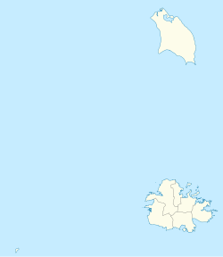
Antigua and Barbuda location map.svg
Red pog.svg
Crabs Hill
Coordinates: 17°02′04″N61°53′28″W / 17.03444°N 61.89111°W / 17.03444; -61.89111
Country Antigua and Barbuda
Island Antigua
Civil parish Saint Mary Parish
Government
  TypeVillage Council [1] (possibly dissolved) [2]
  MP Kelvin Simon
Population
 (2011)
  Total142
Time zone UTC-4 (AST)

Crabs Hill is a village in Saint Mary Parish, Antigua and Barbuda.
Contents

Demographics

Crabs Hill has one enumeration district, ED 81800 CrabbHill.

Census data (2011)

Source: [3]

Individual

Q48 EthnicCounts%
African descendent13293.28%
Caucasian/White53.73%
Mixed (Other)42.99%
Total142100.00%
Q49 ReligionCounts%
Adventist75.22%
Anglican8861.94%
Baptist106.72%
Evangelical10.75%
Moravian21.49%
Nazarene10.75%
Pentecostal117.46%
Roman Catholic53.73%
Wesleyan Holiness75.22%
Don't know/Not stated106.72%
Total142100.00%
Q55 Internet UseCounts%
Yes6546.27%
No7452.24%
Don't know/Not stated21.49%
Total142100.00%
Q58. Country of birthCounts%
Antigua and Barbuda12185.82%
Other Caribbean countries21.49%
Canada53.73%
Dominica32.24%
St. Lucia10.75%
Trinidad and Tobago10.75%
United Kingdom21.49%
USA32.24%
USVI United States Virgin Islands21.49%
Total142100.00%
Q71 Country of Citizenship 1Counts%
Antigua and Barbuda13091.79%
Other Caribbean countries10.75%
Canada42.99%
Dominica21.49%
Trinidad and Tobago10.75%
United Kingdom10.75%
USA21.49%
Total142100.00%
Q71 Country of Citizenship 2 (Country of Second/Dual Citizenship)Counts%
Other Caribbean countries220.00%
Canada220.00%
Dominica110.00%
St. Lucia110.00%
United Kingdom110.00%
USA330.00%
Total11100.00%
NotApp :131
Employment statusCounts%
Employed7365.71%
Unemployed21.90%
Inactive3632.38%
Total111100.00%
NotApp :31

Household

There are 48 households in Crabs Hill.

Total number of personsCounts%
11633.33%
21020.83%
348.33%
4918.75%
536.25%
636.25%
724.17%
9 and over12.08%
Total48100.00%
Q4 Year builtCounts%
Before 1980510.42%
1980 - 1989918.75%
1990 - 1999816.67%
2000 - 2006714.58%
Year 200912.08%
Don't Know/not stated1837.50%
Total48100.00%
Q11 Garbage disposalCounts%
Garbage truck Public4695.83%
Other (inc. burning, burying, compost, dumping)24.17%
Total48100.00%
Q23 3b Laptop ComputerCounts%
Yes1531.25%
No3368.75%
Total48100.00%
Q23 10 RadioCounts%
Yes3572.92%
No1327.08%
Total48100.00%
Q23 9 Mobile DeviceCounts%
Yes3879.17%
No1020.83%
Total48100.00%
Q23 3a Desktop ComputerCounts%
Yes1837.50%
No3062.50%
Total48100.00%
Q24 Motor VehiclesCounts%
01738.64%
11534.09%
21022.73%
312.27%
4 or more12.27%
Total44100.00%
Missing :4
Q25 4 Internet accessCounts%
No2041.67%
Yes2143.75%
Don't know/not declared714.58%
Total48100.00%

Related Research Articles

Telecommunications in Antigua and Barbuda are via media in the telecommunications industry.

<span class="mw-page-title-main">Saint Mary, Antigua and Barbuda</span> Parish in Antigua and Barbuda

Saint Mary, officially the Parish of Saint Mary, is a parish of Antigua and Barbuda on the island of Antigua. Saint Mary borders Saint John to the north, and Saint Paul to the east. Saint Mary is dominated by the Shekerley Mountains, and its northern border is largely defined by the mountains, and by Cooks Creek. The largest city in the parish is Bolans, home to the Jolly Harbour neighbourhood, and the parish church is located in Old Road. Saint Mary was created with the other five original parishes on 11 January 1692. It had a population of 7,341 in 2011, and 8,141 in 2018.

<span class="mw-page-title-main">Saint Paul, Antigua and Barbuda</span> Parish in Antigua and Barbuda

Saint Paul, officially the Parish of Saint Paul, is a parish of Antigua and Barbuda on the island of Antigua. Saint Paul borders Saint Peter and Saint John to the north, Saint Mary to the west, and Saint Philip to the east. Saint Paul is dominated by farmland in the north, with various creeks and Potworks Dam marking its northern border, and low-lying hills to the south, defining its western border with Saint Mary. The largest city fully within the parish is Liberta, the fourth largest city in the country. The parish capital, and the location of the parish church, is Falmouth. The main economic and tourism hub of the parish is English Harbour. Saint Paul was created with the other five original parishes on 11 January 1692. It had a population of 9,004 in 2018.

<span class="mw-page-title-main">Saint Peter, Antigua and Barbuda</span> Parish in Antigua and Barbuda

Saint Peter, officially the Parish of Saint Peter, is a parish of Antigua and Barbuda on the island of Antigua. Saint Peter borders Saint Paul to the south, Saint Philip to the east, and Saint George and Saint John to the west. Saint Peter is dominated by farmland, savanna, and undeveloped fields, and its borders are not well-defined. The largest city fully within the parish is Parham, which is also the capital. However, the portion of the city of All Saints in Saint Peter is significantly larger than Parham. Saint Peter was created with the other five original parishes on 11 January 1692. It had a population of 5,325 in 2011.

Parham Town is a coastal town and port located in and capital of Saint Peter Parish on the island of Antigua, in Antigua and Barbuda. It had a population of 1,491 in 2001.

<span class="mw-page-title-main">Willikies</span> Town in Antigua, Antigua and Barbuda

Willikies is a small settlement in Saint Philip Parish, located in the eastern part of Antigua island in Antigua and Barbuda.

Freetown, officially known as FreeTown, is a town in Antigua. It is located in the southeast of the island, on a peninsula between Willoughby Bay to the south and Nonsuch Bay to the north.

Piggotts, also known as St Mark's Village, is a small township in Saint George Parish on Antigua island in Antigua and Barbuda. It had a population of 1,478 in 2001.

Potters Village is a township located on Antigua in Antigua and Barbuda. It is located in the north of the island, to the east of the capital, St. John's and southwest of Piggotts.

<span class="mw-page-title-main">Bethesda, Antigua and Barbuda</span> Village in Antigua, Antigua and Barbuda

Bethesda is a township in Saint Paul Parish on the island of Antigua, in Antigua and Barbuda.

<span class="mw-page-title-main">Afro-Antiguans and Barbudans</span>

Afro-Antiguans and Afro-Barbudans are Antiguans and Barbudans of entirely or predominantly African ancestry.

<span class="mw-page-title-main">Five Islands, Antigua and Barbuda</span> Village in Antigua, Antigua and Barbuda

Five Islands Village is a village located on the northwest coast of Antigua, within Saint John Parish in Antigua and Barbuda.

<span class="mw-page-title-main">Buckleys</span> Town in Antigua, Antigua and Barbuda

Buckleys is a town in Saint John Parish, Antigua and Barbuda.

<span class="mw-page-title-main">Ebenezer, Antigua and Barbuda</span> Town in Antigua, Antigua and Barbuda

Ebenezer is a town in Saint Mary Parish, Antigua and Barbuda.

<span class="mw-page-title-main">Glanvilles</span> Village in Antigua, Antigua and Barbuda

Glanvilles is a village in Saint Philip Parish, Antigua and Barbuda.

Coolidge is a village and community in Saint George Parish, Antigua and Barbuda.

Montpelier is a small village in Saint Philip Parish, Antigua and Barbuda.

Collins is a village in Saint Philip Parish, Antigua and Barbuda.

Guyanese Antiguans and Guyanese Barbudans are Guyanese people born in or citizens of Guyana.

City Centre is a Major Division/Area within the city of St. John's, Antigua and Barbuda.

References

  1. http://laws.gov.ag/wp-content/uploads/2018/08/cap-466.pdf [ bare URL PDF ]
  2. "The political Neanderthal". 12 March 2020.
  3. "Antigua and Barbuda::Statistics Division/Redatam Webserver | Statistical Process and Dissemination Tool". redatam.org. Retrieved 2021-12-30.