
Sagarmāthā was one of the fourteen zones of Nepal until the restructuring of zones into provinces. The headquarters of Sagarmatha is Rajbiraj. Sagarmāthā is a Nepali word derived from सगर (sagar) meaning "sky" and माथा (māthā) meaning "head".

Jhanjharpur is a town and a sub-division in the Madhubani district of the state of Bihar, India. Jhanjharpur is well connected to the other cities of India with railways or roadways.
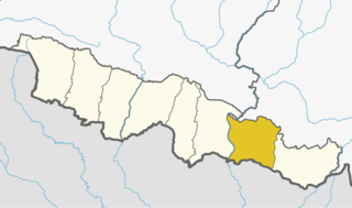
Siraha District (Nepali: सिराहा जिल्लाListen , a district in Province No. 2, is one of the seventy-seven districts of Nepal. It is situated in the Terai belt of Nepal. The district, with Siraha as its district headquarters, covers an area of 1,188 km2. It has population of 637,328 according to census of 2011. Majority of the population here is Yadav, Tharus, Muslims and ethnic minorities with majority population speaking Maithili language and Nepali language.

Birpur is a city and a notified area in Supaul district in the state of Bihar, India. It is a small town on the Indo-Nepal border near the historic Koshi Barrage on the Koshi River. It has an airstrip, which is being modernised and later on will be utilized for commercial as well defence use. It had been made when first prime minister of India Jawaharlal Nehru had landed here to lay the foundation stone of Koshi Barrage. There has been a new helipad constructed next to the airstrip for multi purpose use.

Gaighat is a populated place and the headquarter of Udayapur District located in Province No. 1 of Nepal. It was a Village development committee before 1997. It Incorporated to Triyuga Municipality along with Deuri and Bhoomrasuwa on 26 March 1997.

Birgunj is a metropolitan city in Parsa District in Province No. 2 of southern Nepal. It lies 135 km (84 mi) south of the capital Kathmandu, attached in the north to Raxaul in the border of the Indian state of Bihar. As an entry point to Nepal from Patna and Kolkata, it is known as the "Gateway to Nepal". It is also called "Commercial capital of Nepal". The town has significant economic importance for Nepal as most of the trade with India is via Birgunj and the Indian town of Raxaul. Tribhuvan Highway links Birgunj to Nepal's capital, Kathmandu. Birgunj was one of the first three municipalities formed during the rule of Prime Minister Mohan Shumsher Jang Bahadur Rana. It was declared a Metropolitan City on 22 May 2017 along with Biratnagar and Pokhara. Birgunj is currently the second-largest city in the Terai region of Nepal after Biratnagar and Birgunj is the sixth most populated metropolis of the nation.
Nirmali is a town and a notified area in Supaul district in the Indian state of Bihar.

Triyuga is an urban municipality out of 4 urban municipalities located in the Udayapur district of the Province No. 1 of Nepal. Gaighat is the headquarter of the municipality. According to the 1991 Nepal census, it had a population of 55,291. According to the 2011 Nepal census, Triyuga had 87,557 inhabitants. It is divided into 16 wards. Triyuga Municipality was established on B.S. Chaitra 13, 2053. It was named after Triyuga River. A river which flows through the town. Triyuga is the 3rd largest municipality in Nepal and 1st largest in Province No. 1 in term of size (area). The total area of the municipality is 547.43 square kilometres (211.36 sq mi)

Siraha is the headquarters and municipality of Siraha District, a part of Province No. 2, Nepal. Siraha had a population of 28,442 according to the census of 2011. and a population of 82,531 as of 2015. The mayor ois Asheswor Yadava and the deputy mayor is Dr. Namita Yadav. Both assumed office on 25 September 2017. The town is at 80 metres (260 ft) altitude, 29 kilometres (18 mi) ESE of Janakpur.
Khutauna is a small town in the Madhubani district in northern Bihar state, India. There are 14 Ward in Khutauna block. Khutauna is under Phulparas subdivision bearing its own post office, block. Khutauna is very near to the Nepal border.
Lahan is a city and municipality in Siraha District in the Sagarmatha Zone of south-eastern Nepal. It is connected with Mahendra Highway, which is also called the east–west highway. It is located nearly 350 kilometers or 99.3 miles east of the capital, Kathmandu. Lahan is located at the latitude of 26.717 and longitude of 86.483. It is at an elevation of 111 meters above sea level. It follows Nepali time zone, UTC Offset: +05:45 hours.
Mirchaiya formerly known as Ramnagar Mirchaiya is a municipality in Siraha District in the Sagarmatha Zone of south-eastern Nepal. The municipality was established on 18 May 2014 by merging the existing Rampur Birta, Malhaniyakhori, Radhopur, Ramnagar Mirchaiya, Phulbariya, Sitapur PraDa and Maheshpur Gamharia Village Development Committees. At the time of the 2017 municipality records, it had a population of approx. 52,000 people living in approx 8,496 individual households. This is one of the main business markets for Katari and the southern part of the Siraha district. Raw material produced here includes padday, miazem, and sugar cane. Frequently used Language of Mirchaiya is Maithali. However, People of this locality is well educated they can speak English, Nepali, Hindi and some other local language according to their ethnicity. The famous festival of Mirchaiya is Durgapuja, Jhanda Mela, Holi, Chhat puja, Shreepanchami, Dipawali. The mode of transportation mostly used include: bus, car, bike, bicycle, rickshaw, tempo, and mini bus.
Bhadrapur is a town and municipality in Jhapa District in the Mechi Zone of southeastern Nepal. It lies on the banks of the Mechi River, and shares borders with Bihar state, India on south and West Bengal state on north. There is a border crossing with customs office for goods. Galgalia village in Kishanganj District borders with Bhadrapur
Laukaha is a Town in the district of Madhubani in the Indian state of Bihar. It is close to the border with Nepal and the Nepalese town of Thadi. The population of Laukaha is between 11, 000 and 15, 000.
Kunauli is a town located in the Supaul district of Bihar, India on the border of Nepal's Saptari District. Nearest airport is Rajbiraj Airport 10 KM away. There is a daily flight operated between Rajbiraj and Kathmandu operated by Shree Airlines.
Bhimnagar is a village in Basantpur tehsil of Supaul district in the Indian state of Bihar, south of the Koshi Barrage, near the India-Nepal border. The village has more than 20 hours power supply through Kattaiah power house. Bhimnagar is advanced in education with an 73% literacy rate. It has a Primary Hospital which is now used as Sadar Aspatal. It has been a known place for sports like cricket, Football, Badminton and many other sports. Bhimnagar was greatly impacted by the 2008 Bihar flood of the Kosi River.
Kathauna Bazar is a city in Shambhunath Municipality Ward No. 6, in the Saptari district of Nepal. It is 20 km east of Lahan Municipality, and is the central city of Shambhunath Municipality. Shambhunath municipality's head office is located at Kathauna Bazar. At the time of the 1991 Nepal census it had a population of 5167 people, living in 933 individual households.

The Department of Customs of Nepal is an administration of Government of Nepal under ministry of finance which collects Customs duty, Value Added Tax, Excise and other taxes at the border points and international airport. Department of Customs is responsible in contributing to the economic and social prosperity by providing professional and quality assured Customs services in Nepal. Its mission is Promoting and facilitating legitimate trade, protection of society and collecting the revenue.

Rajbiraj Airport is a domestic airport located in Rajbiraj serving Saptari District, a district in Province No. 2 in Nepal.
Thadhi or Thadi Viswaspatti is a very old border town and a market place of Nepal in Siraha District bordering Indian town of Laukaha. It is currently part of Bhagwanpur Rural municipality. It is located nearly 370 kilometers or 107 miles east of the capital, Kathmandu.
