
Jhanjharpur is a town and a sub-division in the Madhubani district of the state of Bihar, India. Jhanjharpur is well connected to the other cities of India with railways.

Madhubani is a city Municipal Corporation and headquarter of Madhubani district. Madhubani is situated in the Indian state of Bihar. It comes under Darbhanga Division. It is situated at 26 km northeast of Darbhanga City. The Madhuban Raj in Madhubani was created as a consequence. The word "Madhuban" means "forest of honey", from which Madhubani is derived, but sometimes it is also known as "madhu"+"vaani" meaning "sweet" "voice/language".

Madhubani district is one of the thirty-eight districts of Bihar, India, and is a part of Darbhanga division. Its administrative headquarters are located in Madhubani. The district has an area of 3,501 square kilometres (1,352 sq mi) and has a population of 4,487,379.
Siraha District, a district in Madhesh Province, is one of the seventy-seven districts of Nepal. It is situated in the Terai belt of Nepal. The district, with Siraha as its district headquarters, covers an area of 1,188 km2 (459 sq mi). It has population of 637,328 according to census of 2011.The District is bordered with Saptari district in the east, Udayapur districting the north, Bihar state of India in the south and Dhanusa district in the west. Majority of the population here is yadav, Kushwaha(mahato),Tharus, Sahs(sahukar), Muslims and ethnic minorities with majority population speaking English, Maithili language and Nēpālī language.

Birpur is a city and a notified area in Supaul district in the state of Bihar, India. It is a small town on the Indo-Nepal border near the historic Koshi Barrage on the Koshi River. It has an airstrip, which is being modernised and later on will be utilized for commercial as well defence use. It had been made when first prime minister of India Jawaharlal Nehru had landed here to lay the foundation stone of Koshi Barrage. There has been a new helipad constructed next to the airstrip for multi purpose use.
Gaighat is an administrative centre within Triyuga Municipality and the headquarter of Udayapur District located in Province No. 1 of Nepal. Gaighat is divided into 2 wards called Gaighat Bazar and Old Gaighat. The Gaighat is located in Ward No. 11 and Old Gaighat is in Ward No. 12 of Triyuga Municipality. Total area of two wards is 16.11 square kilometres (6.22 sq mi) and total population is 14,243 with 2832 households.
Ghoghardiha is a city and a notified area in Darbhanga division, Madhubani district in the state of Bihar, India. Ghoghardiha is also a Railway Station which connects Saharsa to Laheria Sarai via Nirmali, Jhanjharpur, Lohana and Sakri.
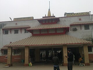
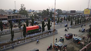
Raxaul is a sub-divisional town in the East Champaran district of the Indian state of Bihar. It is situated at the India-Nepal border with Birgunj city (Nepal). Raxaul is a major railway junction.
Nirmali is a town and a notified area in Supaul district in the Indian state of Bihar.

Triyuga is one of the eight municipalities of Udayapur district of the Koshi Pradesh of Nepal. Gaighat is the headquarter of the municipality. According to the 2021 Nepal census the total population of the municipality is 103,475. It is divided into 16 wards. Triyuga Municipality was established on B.S. Chaitra 13, 2053. It was named after Triyuga River. A river which flows through the town. Triyuga is the 3rd largest municipality in Nepal and 1st largest in Koshi Pradesh in term of size (area). The total area of the municipality is 547.43 square kilometres (211.36 sq mi)
Siraha is the headquarters and municipality of Siraha District, a part of Madhesh Province, Nepal. Siraha had a population of 28,442 according to the census of 2011. and a population of 82,531 as of 2015. The current population of Siraha municipality as of census 2022, is 96,543. It has a male population of 47,306 and female population of 49,237. The present mayor of Siraha Municipality is Dr. Nabin Kumar Yadav and Deputy Mayor is Babita Kumari Sah. Both assumed office on 25 May 2022. His predecessor mayor was Asheswor Yadav and the deputy mayor was Dr. Namita Yadav. Both assumed office on 25 September 2017 and their last working day was on 24 May 2022. The town is at 80 metres (260 ft) altitude, 29 kilometres (18 mi) ESE of Janakpur.

Malangwa is a town, a municipality, and the headquarter of Sarlahi District in Madhesh Province of Nepal. The district's oldest municipality, it is in parliamentary constituency 2. From the Mahendra Highway 25 kilometres (16 mi) south of Nawalpur, a small highway side town. Situated at an altitude of 79 meters (259 ft) above sea level, Malangwa is near the Indian border at Sonbarsa. There is a customs checkpoint at the border crossing.
Khutauna is a small town in the Madhubani district of northern Bihar state, India. There are 14 wards in Khutauna block. Khutauna is under the Phulparas subdivision and has its own post office. Khutauna is very close to the Indo-Nepal border.
Lahan (लहान) is a city and municipality in the Siraha district of Madhesh, Nepal. Lahan is the 36th densest municipality in the country, with a population of 102,031 spread out across 24 wards, the most wards of any Nepalese municipality. It is connected by the Mahendra Highway, which is also called the east-west highway. It is located nearly 261 km east of the capital, Kathmandu via B.P. highway and E-W Highway and 424 km east via Narayanghat-Mugling Highway. Lahan is located at the latitude of 26.717 and longitude of 86.483. It is at an elevation of 111 meters above sea level. It follows the Nepali time zone, UTC Offset: +05:45 hours.
Bhimnagar is a village in Basantpur tehsil of Supaul district in the Indian state of Bihar, south of the Koshi Barrage, near the India-Nepal border. The village has more than 20 hours power supply through Kattaiah power house. Bhimnagar is advanced in education with an 73% literacy rate. It has a Primary Hospital which is now used as Sadar Aspatal. It has been a known place for sports like cricket, Football, Badminton and many other sports. Bhimnagar was greatly impacted by the 2008 Bihar flood of the Kosi River.
Laukaha Bazar railway station serves Laukaha town in Madhubani district in the Indian state of Bihar. It located near the India–Nepal border.
Bagha Kusmar is a small town in the Madhubani district in northern Bihar state, India. It is under Phulparas subdivision. The distance between Bagha Kusmar and its district headquarters is 52 km (32 mi). The distance between Bagha Kusmar and town Khutauna is 7 km (4.3 mi).
Bhagwanpur is a rural municipality in Siraha District in Province No. 2 of south-eastern Nepal. At the time of the 2011 Nepal census it had a population of 20957 people living. It is located nearly 370 kilometers or 107 miles east of the capital, Kathmandu.

The India–Nepal border is an open international boundary running between the republics of India and Nepal. The 1,751 km (1,088.02 mi) long border includes the Himalayan territories as well as Indo-Gangetic Plain of the subcontinent. The current border was delimited after the Sugauli treaty of 1816 between Nepal and the British Raj. Following Indian independence, the prevailing border was recognised as the international border between the Kingdom of Nepal and the Dominion of India.
Thadi or Thadi Viswaspatti is a very old border town and a market place of Nepal in Siraha District bordering Indian town of Laukaha. It is currently part of Bhagwanpur Rural municipality. It is located nearly 370 kilometers or 107 miles east of the capital, Kathmandu. Thadi was part of Tirhut Rulers of Simraungarh. The region was under rule of Karnad Dynasty formed by Nanyadeva Thadi is one of the few towns which is a part of agreed route for Mutual Trade between India and Nepal. Nepal Government has set up a dedicated customs office in the town.
