Bhotekoshi

Last updated
Bhotekoshi

भोटेकोशी गाउँपालिका
Nepal rel location map.svg
Red pog.svg
Bhotekoshi
Location of Bhotekoshi
Coordinates: 27°52′41″N85°58′52″E / 27.878°N 85.981°E / 27.878; 85.981 Coordinates: 27°52′41″N85°58′52″E / 27.878°N 85.981°E / 27.878; 85.981
CountryFlag of Nepal.svg    Nepal
Province Bagmati Pradesh
District Sindhupalchok
Wards5
Established10 March 2017
Government
  Type Rural Council
  ChairpersonMr. Rajkumar Paudel
  Vice-chairpersonMrs. Dabuti Sherpa Lama
Area
  Total278.31 km2 (107.46 sq mi)
Population
 (2011)
  Total17,156
  Density62/km2 (160/sq mi)
Time zone UTC+5:45 (Nepal Standard Time)
Area code(s) 011
Headquarter Phulping Katti
Website Official Website

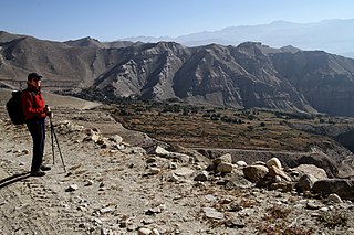
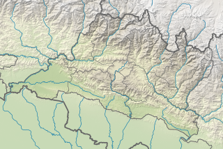
Bhotekoshi is a rural municipality located in Sindhupalchok District of Bagmati Pradesh in Nepal. Sindhupalchok district is divided into twelve local level units, in which three units are urban municipality and nine are rural municipality and Bhotekoshi is one of rural municipalities out of nine. It is located near the border of Tibet-China on Himalayan range. It is surrounded by Dolakha District in east, Bahrabise in south and Jugal in west. Tibet is located on the north side of the rural municipality. Total area of the rural municipality is 273.62 square kilometres (105.65 sq mi) and total population is 19231 individuals. [1] [2] [3]

Contents

The rural municipality was formed on 10 March 2017, when Government of Nepal announced 753 local level units as per the new constitution of Nepal 2015. [4] thus the rural municipality came into existence. The municipality was formed merging following former VDCs: Listikot, Tatopani, Fulping Katti and Marming. The municipality is divided into 5 wards and the admin center of the rural municipality is located at Phulping Katti (ward no. 4).

Places of Interest

Related Research Articles

Sindhupalchok District District in Bagmati Pradesh, Nepal

Sindhupalchok District is a part of Bagmati Province and one of the seventy-seven districts of Nepal, with an area of 2,542 km2 (981 sq mi). The district's headquarters is in Chautara. In 2006, 336,478 people resided in 79 village development committees, in 2011 there were 287,798.

Patarasi Rural municipality in Karnali, Nepal

Patarasi is a rural municipality located in Jumla District of Karnali Province of Nepal.

Bangad Kupinde Place in Karnali, Nepal

Bangad Kupinde is an urban municipality located in Salyan district of Karnali Province of Nepal.

Chhedagad Municipality in Karnali Pradesh, Nepal

Chhedagad is an urban municipality located in the Jajarkot District of Karnali Province of Nepal.

Panchapuri Municipality in Karnali, Nepal

Panchapuri is an urban municipality located in Surkhet District of Karnali Province of Nepal.

Aathabis Municipality in Karnali, Nepal

Aathabis is an urban municipality located in Dailekh District of Karnali Province of Nepal.

Chamunda Bindrasaini Municipality in Karnali, Nepal

Chamunda Bindrasaini is an urban municipality located in Dailekh District of Karnali Province of Nepal.

Gurans, Dailekh Rural municipality in Karnali Pradesh, Nepal

Gurans is a rural municipality located in Dailekh District of Karnali Province of Nepal.

Sinja Rural Municipality Rural municipality in Karnali, Nepal

Sinja is a rural municipality located in Jumla District of Karnali Province of Nepal.

Mahabu Rural municipality in Karnali, Nepal

Mahabu is a rural municipality located in Dailekh District of Karnali Province of Nepal.

Thantikandh Rural municipality in Karnali, Nepal

Thantikandh is a rural municipality located in Dailekh District of Karnali Province of Nepal.

Bhagawatimai Rural municipality in Karnali, Nepal

Bhagawatimai is a rural municipality located in Dailekh District of Karnali Province of Nepal.

Dungeshwor Rural municipality in Karnali, Nepal

Dungeshwar is a rural municipality located in Dailekh District of Karnali Province of Nepal.

Namkha, Nepal Rural municipality in Karnali Pradesh, Nepal

Namkha is a largest rural municipality of Nepal located in Humla District of Karnali Province.

Lo-Ghekar Damodarkunda Rural municipality in Gandaki Pradesh, Nepal

Lo-Ghekar Damodarkunda (earlier:Dalome) is a rural municipality situated in Mustang District of Gandaki Province of Nepal. The rural municipality is situated on the northern part of the Mustang, surrounded by Lomanthang rural municipality on the north, Barhagaun Muktichhetra on the south, Manang District on the south-east and Dolpa District on the west, north-eastern border of the rural municipality touches border with Tibet of China.

Gosaikunda Rural Municipality Rural Municipality in Bagmati Pradesh, Nepal

Gosaikunda is a rural municipality located in Rasuwa District of Bagmati Pradesh in Nepal. Rasuwa district is divided into five rural municipality and Gosaikunda is one of them. It is located near the border of Tibet-China on Himalayan range. It is surrounded by Sindhupalchok District in east, Naukunda gaunpalika and Kalika gaunpalika in south and Uttargaya gaunpalika and Parbatikunda gaunpalika in west. Tibet is located on the north side of the rural municipality. Total area of the rural municipality is 987.77 square kilometres (381.38 sq mi) and total population is 7,143 individuals.

Panchpokhari Thangpal Rural municipality in Bagmati province, Nepal

Panchpokhari Thangpal is a rural municipality located in Sindhupalchok District of Bagmati Province of Nepal. The RM is surrounded by Jugal in the East, Helambu in the West, Rasuwa District covers from North and Melamchi and Indrawati falls in South of the RM.

Duhun Rural Municipality Rural Municipality in Sudurpashchim, Nepal

Duhun is a rural council located in Darchula District of Sudurpashchim province in Nepal.

Badhaiyatal Rural Municipality in Province No. 5, Nepal

Badhaiyatal is a rural municipality located in Bardiya District of Province No. 5 of Nepal.

Geruwa Rural Municipality in Province No. 5, Nepal

Geruwa is a rural municipality located in Bardiya District of Province No. 5 of Nepal.

References

  1. "District Corrected Last for RAJAPATRA" (PDF). www.mofald.gov.np. Retrieved 17 July 2018.
  2. "स्थानीय तहहरुको विवरण" [Details of the local level bodies]. www.mofald.gov.np/en (in Nepali). Ministry of Federal Affairs and Local Development. Archived from the original on 31 August 2018. Retrieved 17 July 2018.
  3. "Official website of Bhotekoshi rural municipality". www.bhotekoshimun.gov.np. Retrieved 8 May 2019.
  4. "New local level structure comes into effect from today". www.thehimalayantimes.com. The Himalayan Times. 10 March 2017. Retrieved 17 July 2018.
  5. "Welcome to Tatopani". www.tatopani.com. Retrieved 8 May 2019.
  6. "Tatopani Custom Office". www.customs.gov.np. Retrieved 8 May 2019.