
Paguate is a census-designated place (CDP) in Cibola County, New Mexico, United States. The population was 421 at the 2010 census.

Aragon is a census-designated place on the Tularosa River in Catron County, New Mexico, United States. As of the 2010 census it had a population of 94. It is located 7 miles (11 km) northeast of Apache Creek.
Luna is a census-designated place in northwestern Catron County, New Mexico, United States. As of the 2010 census it had a population of 158. It is situated on the San Francisco River and U.S. Route 180, 7 miles (11 km) east of the Arizona border and 20 miles (32 km) northwest of Reserve, the Catron county seat.
Quemado is a census-designated place in Catron County, New Mexico, United States. As of the 2010 census it had a population of 228. Walter De Maria's 1977 art installation, The Lightning Field, is between Quemado and Pie Town, New Mexico.
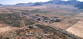
Rodeo is a census-designated place (CDP) in Hidalgo County, New Mexico, United States. It lies less than one mile (1.6 km) from the border with Arizona on New Mexico State Road 80. As of the 2010 census, the population of Rodeo was 101.
San Rafael is a census-designated place (CDP) in Cibola County, New Mexico, United States. As of the 2010 census it had a population of 933. Also known as "Bikyaya" or "El Gallo", it lies at an elevation of 6,470 feet (1,970 m) above sea level and is located in north-central Cibola County at. New Mexico State Road 53 passes through the community, leading north 3 miles (5 km) to Interstate 40 and 5 miles (8 km) to the center of Grants, the county seat.
Lumberton is a census-designated place in Rio Arriba County, New Mexico, United States. Its population was 73 as of the 2010 census. U.S. Route 64 passes through the community.
Manzano Springs is a census-designated place (CDP) in Torrance and Bernalillo counties, New Mexico, United States. The population was 137 at the 2010 census. It is part of the Albuquerque Metropolitan Statistical Area.

Costilla is a census-designated place in Taos County, New Mexico, United States. Its population was 205 as of the 2010 census. Costilla has a post office with ZIP code 87524. State roads 196 and 522 intersect in the community.
Caballo is a census-designated place in Sierra County, New Mexico, United States. Its population was 112 as of the 2010 census. Caballo has a post office with ZIP code 87931. The community is located along New Mexico State Road 187, north and south of Exit 63 on Interstate 25.
San Miguel is a census-designated place in Doña Ana County, New Mexico, United States. Its population was 1,153 as of the 2010 census. San Miguel has a post office with ZIP code 88058. The community is located at the junction of state routes 28 and 192.
North Hurley is a census-designated place in Grant County, New Mexico, United States. Its population was 300 as of the 2010 census. The community is located north of Hurley along U.S. Route 180.
Anzac Village is a census-designated place (CDP) in Cibola County, New Mexico, United States. The population was 54 at the 2010 census.
Las Tusas is a census-designated place (CDP) in Cibola County, New Mexico, United States. At the 2010 census the CDP was known as Bluewater Acres and had a population of 206.
Moquino is a census-designated place (CDP) in Cibola County, New Mexico, United States. The population was 37 at the 2010 census.
Livingston Wheeler is an unincorporated community and census-designated place in Eddy County, New Mexico, United States. Its population was 609 as of the 2010 census. The community is located on the southeastern edge of Carlsbad along New Mexico State Road 216.
La Mesilla is a census-designated place in Río Arriba County, New Mexico, United States. Its population was 1,772 as of the 2010 census.
North Light Plant is an unincorporated community and census-designated place in San Juan County, New Mexico, United States. Its population was 414 as of the 2010 census. New Mexico State Road 574 passes through the community.
North San Ysidro is an unincorporated community and census-designated place in San Miguel County, New Mexico, United States. Its population was 159 as of the 2010 census.
Jacona is an unincorporated community and census-designated place in Santa Fe County, New Mexico, United States. Its population was 412 as of the 2010 census.

