
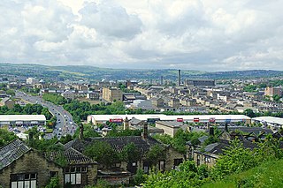
Cleckheaton is a town in the metropolitan borough of Kirklees, West Yorkshire, England. Historically part of the West Riding of Yorkshire, it is situated south of Bradford, east of Brighouse, west of Batley and south-west of Leeds. It is at the centre of the Spen Valley and was the major town in the former borough of Spenborough. Cleckheaton has a history as a mill town and forms part of the Heavy Woollen District.

Tong is a ward within the City of Bradford Metropolitan District Council, West Yorkshire, England, named after Tong village which is its oldest settlement. The population at the 2011 Census was 20,608.

Yeadon is a town within the metropolitan borough of the City of Leeds, West Yorkshire, England.
Manningham is a historically industrial workers area as well as a council ward of Bradford, West Yorkshire, England. The population of the 2011 Census for the Manningham Ward was 19,983.

A civil parish is a subnational entity, forming the lowest unit of local government in England. There are 101 civil parishes in the ceremonial county of West Yorkshire, most of the county being unparished. At the 2001 census, there were 557,369 people living in the parishes, accounting for 26.8 per cent of the county's population.
Clayton, or Clayton Village, is a civil parish in the City of Bradford metropolitan borough in West Yorkshire, England, situated 3 miles (4.8 km) to the west of Bradford city centre. It is listed in the Domesday Book, meaning it dates back to at least the 11th century and was privately owned from 1160 to 1866. It was noted for its clay. More recently, Clayton was a key location in the British and international wool trade, being the home of the British Wool Marketing Board headquarters. The old building was demolished and converted into housing in the late 1990s. The village re-acquired civil parish status with a parish council in 2004.

Heaton is a ward within the City of Bradford Metropolitan District Council, West Yorkshire, England. The population at the 2001 census was 16,913, which had increased to 17,121 at the 2011 Census. Historically part of the West Riding of Yorkshire, the ward includes the villages of Frizinghall, Heaton and Daisy Hill, extending to Chellow Heights Reservoir on the western edge and the Bradford-Shipley railway line on the eastern edge. Frizinghall railway station is on the edge of the ward. Located in Heaton is the former St Bede's Grammar School and Bradford Grammar School. The official residence of the Bishop of Bradford is also in Heaton. Heaton has three public houses and a range of shops and restaurants. An ancient woodland, Heaton Woods, stretches from the village to Shipley. The ward is home to 5 golf courses.

Bradford South is a constituency in West Yorkshire represented in the House of Commons of the UK Parliament since 2015 by Judith Cummins of the Labour Party.

Haughton is a former civil parish that covered the eastern portion of Denton, now in Tameside district, in the county of Greater Manchester, England, formerly in Lancashire. The township probably dates from the Anglo-Saxon times, and was first recorded as Halcton or Halghton in the thirteenth century. In Saxon, Haughton means 'settlement' (ton) on 'low-lying land' (Haugh), and probably refers to the ancient township's location in the Tame Valley.

Royds is a ward within the City of Bradford Metropolitan District Council in the county of West Yorkshire, England. The population at the 2011 Census was 17,360.

Wibsey is a ward within the City of Bradford Metropolitan District Council, West Yorkshire, England. The population had increased to 14,671 at the 2011 Census. Wibsey is named after Wibsey village which makes up the main part of the ward. As well as the area of Wibsey, the ward includes the area of Bankfoot to the east and much of the area of Odsal. It is located on a ridge which runs from the city centre, up to Queensbury, which has been described as one of the highest villages in England.

Wyke is an area of Bradford and a ward within the City of Bradford Metropolitan District Council in the county of West Yorkshire, England. The population taken at the 2011 Census was 14,958.

Bradford East is a constituency in West Yorkshire represented in the House of Commons of the UK Parliament since 2015 by Imran Hussain of the Labour Party, until his suspension and the withdrawal of the whip on 23 July 2024, as a result of his voting to scrap the two child benefit cap. He now sits as an independent MP until the whip is re-established.
Osmondthorpe a district of east Leeds in West Yorkshire, England is considered part of the Halton Moor district.
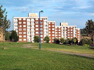
Holme Wood or Holmewood is a housing estate in Bradford, West Yorkshire, England.

Wike is a hamlet and a former civil parish, now in the parish of Harewood, north of Leeds, in the Leeds district, in the county of West Yorkshire, England. It is north of Shadwell and Roundhay, west of Scarcroft and south of East Keswick. Many residents use facilities in Leeds as well as in the nearby town of Wetherby. In 1931 the parish had a population of 88.

Low Moor is a village in the metropolitan borough of the City of Bradford in West Yorkshire, England.

Tong or Tong Village is a village and former civil parish in the City of Bradford metropolitan district, West Yorkshire, England. It is a historic village, and gives its name to the larger electoral ward of Tong.

Royds Hall Manor is one of the surviving manor houses in the Yorkshire Region. It is a Grade II* listed building situated on an elevation over 700 feet above sea level in Bradford, West Yorkshire, England and was once the residence of the Lords of the Manor of North Bierley and Wibsey.


