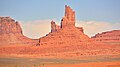
Big Indian | |
---|---|
![]() West aspect | |
Highest point | |
Elevation | 6,120 ft (1,865 m) [1] |
Prominence | 580 ft (177 m) [1] |
Parent peak | Brighams Tomb (6,739 ft) [1] |
Isolation | 0.93 mi (1.50 km) [1] |
Coordinates | 37°01′13″N110°05′31″W / 37.0203836°N 110.0919079°W [2] |
Geography | |
Location | Monument Valley San Juan County, Utah, U.S. |
Parent range | Colorado Plateau [3] |
Topo map | USGS Monument Pass |
Geology | |
Rock age | Permian |
Mountain type | Butte |
Rock type | Sandstone |
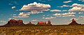
Big Indian is a 6,120-foot-elevation (1,865-meter) summit in San Juan County, Utah, United States. [2]
Big Indian is situated three miles (4.8 km) north-northeast of the Monument Valley Tribal Park Visitor Center, on Navajo Nation land. It is an iconic landform of Monument Valley and can be seen from Highway 163. Precipitation runoff from this landform's slopes drains into the San Juan River drainage basin. [3] Topographic relief is significant as the summit rises 700 feet (213 meters) above the surrounding terrain in 0.25 mile (0.4 km). The nearest higher summit is Sentinel Mesa, 0.62 miles (1.00 km) to the southwest. [3] This landform's toponym was officially adopted in 1964 by the United States Board on Geographic Names. [2] It is so named because the butte resembles the face of a native American looking south-southeast into the valley. [4] "Big Chief" and "Big Indian Butte" were alternate names that were ultimately rejected. [5]
Big Indian is composed of two principal strata. The bottom layer is slope-forming Organ Rock Shale underlaying cliff-forming De Chelly Sandstone. The rock was deposited during the Permian period. The buttes and mesas of Monument Valley are the result of the Organ Rock Shale being more easily eroded than the overlaying sandstone. [6]
Spring and fall are the most favorable seasons to visit Big Indian. According to the Köppen climate classification system, it is located in a semi-arid climate zone with cold winters and hot summers. Summers average 54 days above 90 °F (32 °C) annually, and highs rarely exceed 100 °F (38 °C). Summer nights are comfortably cool, and temperatures drop quickly after sunset. Winters are cold, but daytime highs are usually above freezing. Winter temperatures below 0 °F (−18 °C) are uncommon, though possible. This desert climate receives less than 10 inches (250 millimeters) of annual rainfall, and snowfall is generally light during the winter. [7]
Sentinel Mesa is a 6,450-foot-elevation (1,966-meter) summit in San Juan County, Utah, United States. It is situated 1.5 miles (2.4 km) north of the Monument Valley visitor center on Navajo Nation land and can be seen from Highway 163. The mesa is immediately northwest of the iconic West and East Mitten Buttes. The nearest higher neighbor is Brighams Tomb, 2.64 miles (4.25 km) to the north-northeast. Precipitation runoff from this mesa's west slope drains to Mitchell Butte Wash, whereas the east slope drains to West Gypsum Creek, which are both part of the San Juan River drainage basin. The "Sentinel" name refers to how the mesa oversees Monument Valley which the Navajo consider as one of the "door posts" to Monument Valley. The landform's toponym has been officially adopted by the U.S. Board on Geographic Names.
Eagle Mesa is a 6,624-foot-elevation (2,019-meter) summit in San Juan County, Utah, United States.
Brighams Tomb is a 6,739-foot-elevation (2,054-meter) summit in San Juan County, Utah, United States.
Mitchell Mesa is a 6,586-foot-elevation (2,007-meter) summit in Navajo County, Arizona, United States.
Spearhead Mesa is a 5,998-foot-elevation (1,828-meter) summit in Navajo County, Arizona, United States.
Rain God Mesa is a 5,921-foot-elevation (1,805-meter) summit in Navajo County, Arizona, United States.
Camel Butte is a 5,847-foot-elevation (1,782-meter) summit in Navajo County, Arizona, United States.
Elephant Butte is a 5,981-foot-elevation (1,823-meter) summit in Navajo County, Arizona, United States.
Cly Butte is a 5,820-foot-elevation (1,774-meter) summit in Navajo County, Arizona, United States.
Setting Hen is a 6,293-foot-elevation (1,918-meter) summit in San Juan County, Utah, United States.
Mitchell Butte is a 6,383-foot-elevation (1,946-meter) summit in Navajo County, Arizona, United States.
Gray Whiskers is a 6,385-foot-elevation (1,946-meter) summit in Navajo County, Arizona, United States.
Castle Rock is a 6,340-foot-elevation (1,932-meter) summit in San Juan County, Utah, United States.
Rooster Rock is a 5,985-foot-elevation (1,824-meter) summit in Apache County, Arizona, United States.
Thunderbird Mesa is a 5,814-foot-elevation (1,772-meter) summit in Navajo County, Arizona, United States.
King-on-his-Throne is a 6,165-foot-elevation (1,879-meter) summit in San Juan County, Utah, United States.
Stagecoach is a 6,302-foot-elevation (1,921-meter) summit in San Juan County, Utah, United States.
Setting Hen Butte is a 5,055-foot-elevation (1,541-meter) summit in San Juan County, Utah, United States.
Franklin Butte is a 5,179-foot-elevation (1,579-meter) summit in San Juan County, Utah, United States.
Battleship Rock is a 5,422-foot-elevation (1,653-meter) summit in San Juan County, Utah, United States.