| Eagle Mesa | |
|---|---|
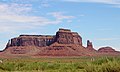
 Southwest aspect | |
| Highest point | |
| Elevation | 6,624 ft (2,019 m) [1] |
| Prominence | 880 ft (268 m) [2] |
| Parent peak | Brighams Tomb (6,739 ft) [2] |
| Isolation | 2.05 mi (3.30 km) [2] |
| Coordinates | 37°02′51″N110°07′18″W / 37.0476248°N 110.1216332°W [1] |
| Geography | |
 Eagle Mesa Location in Utah  Eagle Mesa Eagle Mesa (the United States) | |
| Location | Monument Valley San Juan County, Utah, U.S. |
| Parent range | Colorado Plateau [3] |
| Topo map | USGS Monument Pass |
| Geology | |
| Mountain type | Mesa |
| Rock type | Sandstone |
| Climbing | |
| Easiest route | class 5.x climbing [2] |
Eagle Mesa is a 6,624-foot-elevation (2,019-meter) summit in San Juan County, Utah, United States. [1]