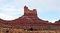
Setting Hen

Last updated
Setting Hen
Monument Valley with afternoon light (8225361819).jpg
South aspect
Highest point
Elevation 6,293 ft (1,918 m) [1]
Prominence 440 ft (130 m) [2]
Parent peak Eagle Mesa (6,624 ft) [2]
Isolation 0.71 mi (1.14 km) [2]
Coordinates 37°03′10″N110°06′38″W / 37.0527313°N 110.1105839°W / 37.0527313; -110.1105839 [1]
Geography
USA Utah relief location map.svg
Red triangle with thick white border.svg
Setting Hen
Location in Utah
Usa edcp relief location map.png
Red triangle with thick white border.svg
Setting Hen
Setting Hen (the United States)
Location Monument Valley
San Juan County, Utah, U.S.
Parent range Colorado Plateau [3]
Topo map USGS Monument Pass
Geology
Age of rock Permian
Type of rock Sandstone

Setting Hen is a 6,293-foot-elevation (1,918-meter) summit in San Juan County, Utah, United States. [1]

Contents

Description

Setting Hen is situated 5.5 miles (8.9 km) northeast of Oljato–Monument Valley, Utah, on Navajo Nation land. It is an iconic landform of Monument Valley and can be seen from Highway 163. Precipitation runoff from this butte's slopes drains into the San Juan River drainage basin. [3] Topographic relief is significant as the summit rises 600 feet (183 meters) above surrounding terrain in 0.25 mile (0.4 km). The nearest higher neighbor is Eagle Mesa, 0.71 miles (1.14 km) to the southwest. [2] This landform's toponym has been officially adopted by the United States Board on Geographic Names, [1] and the descriptive name refers to the profile resembling a sitting hen when viewed from the southeast. [4]

Geology

Setting Hen is a butte composed of two principal strata. The bottom layer is Organ Rock Shale and the upper stratum is cliff-forming De Chelly Sandstone. The rock was deposited during the Permian period. The buttes and mesas of Monument Valley are the result of the Organ Rock Shale being more easily eroded than the overlaying sandstone. [5]

Climate

Spring and fall are the most favorable seasons to visit Setting Hen. According to the Köppen climate classification system, it is located in a semi-arid climate zone with cold winters and hot summers. Summers average 54 days above 90 °F (32 °C) annually, and highs rarely exceed 100 °F (38 °C). Summer nights are comfortably cool, and temperatures drop quickly after sunset. Winters are cold, but daytime highs are usually above freezing. Winter temperatures below 0 °F (−18 °C) are uncommon, though possible. This desert climate receives less than 10 inches (250 millimeters) of annual rainfall, and snowfall is generally light during the winter. [6]

See also

Related Research Articles

<span class="mw-page-title-main">Butte</span> Isolated hill with steep, often vertical sides and a small, relatively flat top

In geomorphology, a butte is an isolated hill with steep, often vertical sides and a small, relatively flat top; buttes are smaller landforms than mesas, plateaus, and tablelands. The word butte comes from the French word butte, meaning knoll ; its use is prevalent in the Western United States, including the southwest where mesa is used for the larger landform. Due to their distinctive shapes, buttes are frequently landmarks in plains and mountainous areas. To differentiate the two landforms, geographers use the rule of thumb that a mesa has a top that is wider than its height, while a butte has a top that is narrower than its height.

<span class="mw-page-title-main">Monument Valley</span> Region of the Colorado Plateau, US

Monument Valley is a region of the Colorado Plateau characterized by a cluster of sandstone buttes, with the largest reaching 1,000 ft (300 m) above the valley floor. The most famous butte formations are located in northeastern Arizona along the Utah–Arizona state line. The valley is considered sacred by the Navajo Nation, the Native American people within whose reservation it lies.

<span class="mw-page-title-main">Grand Mesa</span> Mountain in Colorado, US

The Grand Mesa is a large mesa in western Colorado in the United States. It is the largest flat-topped mountain in the world. It has an area of about 500 square miles (1,300 km2) and stretches for about 40 miles (60 km) east of Grand Junction between the Colorado River and the Gunnison River, its tributary to the south. The north side of the mesa is drained largely by Plateau Creek, a smaller tributary of the Colorado. The west side is drained largely by Kannah Creek, which is received to the west by the lower Gunnison River. The mesa rises about 6,000 feet (1,800 m) above the surrounding river valleys, including the Grand Valley to the west, reaching an elevation of about 11,000 feet (3,400 m). Much of the mesa is within Grand Mesa National Forest. Over 300 lakes, including many reservoirs created and used for drinking and irrigation water, are scattered along the top of the formation. The Grand Mesa is flat in some areas, but quite rugged in others.

<span class="mw-page-title-main">West and East Mitten Buttes</span> Buttes in Arizona, United States

The West and East Mitten Buttes are two buttes in the Monument Valley Navajo Tribal Park in northeast Navajo County, Arizona. When viewed from the south, the buttes appear to be two giant mittens with their thumbs facing inwards.

<span class="mw-page-title-main">Owl Rock</span> Landform in Navajo County, Arizona

Owl Rock is a 6,547-foot elevation sandstone summit located south of Monument Valley, in northeast Arizona. It is situated 7 miles (11 km) north of Kayenta on Navajo Nation land, and can be seen from Highway 163 perched on the east edge of Tyende Mesa, where it towers 1,000 feet above the surrounding terrain. Its nearest higher neighbor is Agathla Peak, 1.4 miles (2.3 km) to the east-northeast, on the opposite side of this highway. Precipitation runoff from this feature drains into El Capitan Wash, which is part of the San Juan River drainage basin. The first ascent of Owl Rock was made in April 1966 by Fred Beckey and Harvey Carter by climbing cracks on the west face, and then bolting up a smooth south nose to the summit. They employed 20 pitons and 14 bolts on this route called Warpath. The descriptive name stems from its uncanny resemblance to an owl when viewed from the east. This feature is known as Bee 'Adizí in Navajo language meaning "spindle", and this sacred place is considered to be a spindle left behind by the Holy People. A newer name for it is Tsé Ts'óózí, meaning "Slim Rock".

<span class="mw-page-title-main">Bridger Jack Butte</span> Rock formation in Utah, United States

Bridger Jack Butte is a sandstone butte located in Bears Ears National Monument, in San Juan County, Utah, United States. Set at the northern tip of Bridger Jack Mesa and above the confluence of Indian and Lavender Creeks, the summit rises to an elevation of 5,890 feet, and towers over 700 feet above the surrounding terrain and floor of Lavender Canyon to its west. This landmark is situated four miles southeast of the Sixshooter Peaks, and is visible from State Route 211 between Newspaper Rock and the Needles District of Canyonlands National Park. "Bridger Jack" was a Paiute medicine man.

<span class="mw-page-title-main">Gregory Butte</span> Butte in Utah, United States

Gregory Butte is a 4,651-foot elevation sandstone summit located in Glen Canyon National Recreation Area, in San Juan County of southern Utah. It is situated 7.3 miles (11.7 km) northeast of Tower Butte, and 16 miles (26 km) northeast of the town of Page. This iconic landmark of the Lake Powell area towers nearly 1,000 feet above the lake. Before Lake Powell was formed in the 1970s, this butte was set within a meander of the Colorado River. Gregory Butte is a butte composed of Entrada Sandstone. This sandstone, which was originally deposited as sandy mud on a tidal flat, is believed to have formed about 160 million years ago during the Jurassic period as a giant sand sea, the largest in Earth's history. This geographical feature's name was officially adopted in 1977 by the U.S. Board on Geographic Names. Geologist Herbert E. Gregory (1869–1952), mapped much of the bedrock geology of the Colorado Plateau, particularly in geologic monographs concentrating on what is now Navajo Nation land in northern Arizona and southern Utah where this butte is located. According to the Köppen climate classification system, Gregory Butte is located in an arid climate zone with hot, very dry summers, and chilly winters with very little snow.

<span class="mw-page-title-main">Boundary Butte (Rainbow Plateau)</span> Butte on the Rainbow Plateau in San Juan County, Utah, United States

Boundary Butte is a 4,934-foot elevation sandstone summit located south of Lake Powell, in extreme southwestern San Juan County, Utah, United States, just north of the Arizona border. It is situated on Navajo Nation land, 11.5 miles (18.5 km) northeast of the town of Page, and towers 1,200 feet above the lake as a landmark of the area. It lies on the Utah-Arizona border, hence its name.

<span class="mw-page-title-main">Square Butte (Arizona)</span> Landform in Coconino County, Navajo Nation, Arizona

Square Butte is a 7,140-foot-elevation (2,180 m) sandstone summit located on Navajo Nation land, in Coconino County of northern Arizona. It is situated 35 miles southeast of the town of Page, and nine miles (14 km) east of Kaibito, where it towers over 700 feet (210 m) above the surrounding terrain as a landmark alongside Arizona State Route 98. Square Butte is known as Tsé Dikʼání in Navajo language, meaning "square rock." Its nearest higher neighbor is White Mesa, two miles (3.2 km) to the south. Precipitation runoff from Square Butte drains to northwest into Square Butte Wash or northeast into Potato Canyon, then ultimately Lake Powell, all part of the Colorado River drainage basin. According to the Köppen climate classification system, Square Butte is located in an arid climate zone with hot, very dry summers, and chilly winters. Spring and fall are the most favorable seasons to visit. The top of Square Butte is composed of Entrada Sandstone including the Cow Springs Member, and it overlays Carmel Formation, all of which was deposited in the Jurassic period.

<span class="mw-page-title-main">Sentinel Mesa</span> Mountain in Utah, United States

Sentinel Mesa is a 6,450-foot-elevation (1,966-meter) summit in San Juan County, Utah, United States. It is situated 1.5 miles (2.4 km) north of the Monument Valley visitor center on Navajo Nation land and can be seen from Highway 163. The mesa is immediately northwest of the iconic West and East Mitten Buttes. The nearest higher neighbor is Brighams Tomb, 2.64 miles (4.25 km) to the north-northeast. Precipitation runoff from this mesa's west slope drains to Mitchell Butte Wash, whereas the east slope drains to West Gypsum Creek, which are both part of the San Juan River drainage basin. The "Sentinel" name refers to how the mesa oversees Monument Valley which the Navajo consider as one of the "door posts" to Monument Valley. The landform's toponym has been officially adopted by the U.S. Board on Geographic Names.

<span class="mw-page-title-main">Eagle Mesa</span> Mountain in Utah, United States

Eagle Mesa is a 6,624-foot-elevation (2,019-meter) summit in San Juan County, Utah, United States.

<span class="mw-page-title-main">Brighams Tomb</span>

Brighams Tomb is a 6,739-foot-elevation (2,054-meter) summit in San Juan County, Utah, United States.

Mitchell Mesa is a 6,586-foot-elevation (2,007-meter) summit in Navajo County, Arizona, United States.

<span class="mw-page-title-main">Spearhead Mesa</span> Mountain in Arizona, United States

Spearhead Mesa is a 5,998-foot-elevation (1,828-meter) summit in Navajo County, Arizona, United States.

<span class="mw-page-title-main">Rain God Mesa</span> Mountain in Arizona, United States

Rain God Mesa is a 5,921-foot-elevation (1,805-meter) summit in Navajo County, Arizona, United States.

<span class="mw-page-title-main">Camel Butte</span> Mountain in Arizona, United States

Camel Butte is a 5,847-foot-elevation (1,782-meter) summit in Navajo County, Arizona, United States.

<span class="mw-page-title-main">Elephant Butte (Monument Valley)</span> Mountain in Arizona, United States

Elephant Butte is a 5,981-foot-elevation (1,823-meter) summit in Navajo County, Arizona, United States.

<span class="mw-page-title-main">Cly Butte</span> Mountain in Arizona, United States

Cly Butte is a 5,820-foot-elevation (1,774-meter) summit in Navajo County, Arizona, United States.

<span class="mw-page-title-main">Mitchell Butte</span> Mountain in Arizona, United States

Mitchell Butte is a 6,383-foot-elevation (1,946-meter) summit in Navajo County, Arizona, United States.

<span class="mw-page-title-main">Gray Whiskers</span> Mountain in Arizona, United States

Gray Whiskers is a 6,385-foot-elevation (1,946-meter) summit in Navajo County, Arizona, United States.

References

  1. 1 2 3 4 "Setting Hen". Geographic Names Information System . United States Geological Survey, United States Department of the Interior . Retrieved 2024-08-27.
  2. 1 2 3 4 "Setting Hen - 6,340' UT". listsofjohn.com. Retrieved 2024-08-27.
  3. 1 2 "Setting Hen, Utah". Peakbagger.com. Retrieved 2024-08-27.
  4. Monument Valley, City of Aztec, aztecnm.com, Retrieved 2024-08-27.
  5. Monument Valley, Arizona, Arizona Geological Survey, Retrieved 2024-08-22.
  6. Climate Summary for Kayenta, Arizona