| Brighams Tomb | |
|---|---|
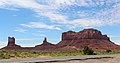
 North aspect | |
| Highest point | |
| Elevation | 6,739 ft (2,054 m) [1] |
| Prominence | 1,225 ft (373 m) [2] |
| Parent peak | Agathla Peak (7,099 ft) [2] |
| Isolation | 16.59 mi (26.70 km) [2] |
| Coordinates | 37°02′46″N110°05′04″W / 37.0459830°N 110.0843896°W [1] |
| Naming | |
| Etymology | Brigham's Tomb |
| Geography | |
 Brighams Tomb Location in Utah  Brighams Tomb Brighams Tomb (the United States) | |
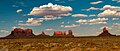
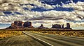
| Location | Monument Valley San Juan County, Utah, U.S. |
| Parent range | Colorado Plateau [3] |
| Topo map | USGS Monument Pass |
| Geology | |
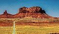
| Rock type | Sandstone |
| Climbing | |
| Easiest route | class 5.x climbing [2] |
Brighams Tomb is a 6,739-foot-elevation (2,054-meter) summit in San Juan County, Utah, United States. [1]