Gordon 86 is a Cree Indian reserve in Saskatchewan, Canada located about 61 kilometres (38 mi) north-west of Fort Qu'Appelle. Also known as the George Gordon Reserve, it is one of three territories of the George Gordon First Nation, as arranged by the signing of Treaty 4. The reserve has an area of 14,438.3 hectares. In the 2016 Canadian Census, it recorded a population of 837 living in 218 of its 238 total private dwellings. In the same year, its Community Well-Being index was calculated at 52 of 100, compared to 58.4 for the average First Nations community and 77.5 for the average non-Indigenous community. It is almost completely surrounded by the rural municipality of Touchwood No. 248.
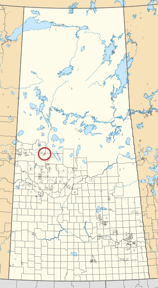
Ahtahkakoop 104 is an Indian reserve of the Ahtahkakoop Cree Nation in Saskatchewan. It is about 72 kilometres (45 mi) northwest of Prince Albert. In the 2016 Canadian Census, it recorded a population of 1,472 living in 386 of its 424 total private dwellings. In the same year, its Community Well-Being index was calculated at 46 of 100, compared to 58.4 for the average First Nations community and 77.5 for the average non-Indigenous community.
Canoe Lake 165 is an Indian reserve of the Canoe Lake Cree First Nation in the boreal forest of northern Saskatchewan, Canada. Its location is on Canoe Lake approximately thirty miles west of Beauval, within the ancient hunting grounds of the Woodland Cree. In the 2016 Canadian Census, it recorded a population of 912 living in 250 of its 273 total private dwellings. In the same year, its Community Well-Being index was calculated at 53 of 100, compared to 58.4 for the average First Nations community and 77.5 for the average non-Indigenous community. The reserve includes the settlement of Canoe Narrows. The name of the reserve and the settlement in Cree is nêhiyaw-wapâsihk ᓀᐦᐃᔭᐤ ᐘᐹᓯᕽ.
Grandmother's Bay 219 is an Indian reserve of the Lac La Ronge Indian Band in Saskatchewan. Located on Otter Lake, part of the Churchill River system, it is about 77 kilometres (48 mi) north-east of Lac la Ronge. In the 2016 Canadian Census, it recorded a population of 342 living in 101 of its 115 total private dwellings. In the same year, its Community Well-Being index was calculated at 44 of 100, compared to 58.4 for the average First Nations community and 77.5 for the average non-Indigenous community.

Seekaskootch 119 is an Indian reserve of the Onion Lake Cree Nation in Saskatchewan. It is 142 kilometres northwest of North Battleford. In the 2016 Canadian Census, it recorded a population of 2574 living in 578 of its 639 total private dwellings. In the same year, its Community Well-Being index was calculated at 53 of 100, compared to 58.4 for the average First Nations community and 77.5 for the average non-Indigenous community.

Buffalo River Dene Nation 193 is an Indian reserve of the Buffalo River Dene Nation in Saskatchewan. It is 84 kilometres northwest of Île-à-la-Crosse. In the 2016 Canadian Census, it recorded a population of 783 living in 233 of its 260 total private dwellings. In the same year, its Community Well-Being index was calculated at 54 of 100, compared to 58.4 for the average First Nations community and 77.5 for the average non-Indigenous community.

Fishing Lake 89 is an Indian reserve of the Fishing Lake First Nation in Saskatchewan. It is 119 kilometres (74 mi) north of Fort Qu'Appelle. In the 2016 Canadian Census, it recorded a population of 406 living in 128 of its 161 total private dwellings. In the same year, its Community Well-Being index was calculated at 54 of 100, compared to 58.4 for the average First Nations community and 77.5 for the average non-Indigenous community.

Cumberland House Cree Nation 20 is an Indian reserve of the Cumberland House Cree Nation in Saskatchewan. The reserve is on Cumberland Island in the Saskatchewan River Delta, about 96 kilometres (60 mi) south-west of Flin Flon.
Eagles Lake 165C is an Indian reserve of the Canoe Lake Cree First Nation in Saskatchewan. It consists of all that portion of Township 59, Range 14, west of the Third Meridian. In the 2016 Canadian Census, it recorded a population of 92 living in 29 of its 32 total private dwellings. In the same year, its Community Well-Being index was calculated at 72 of 100, compared to 58.4 for the average First Nations community and 77.5 for the average non-Indigenous community.
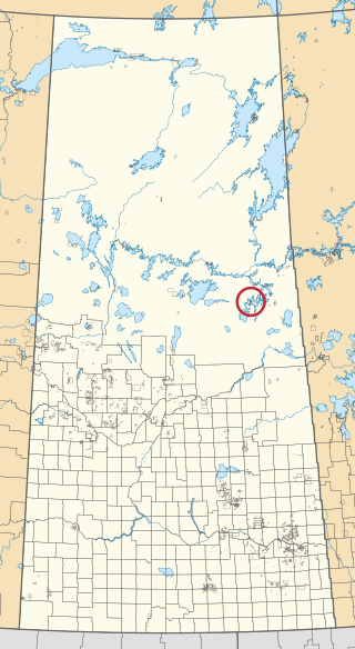
Kimosom Pwatinahk 203 is an Indian reserve of the Peter Ballantyne Cree Nation in Saskatchewan. It is on the south shore of the northerly part of Deschambault Lake. In the 2016 Canadian Census, it recorded a population of 1061 living in 199 of its 221 total private dwellings. In the same year, its Community Well-Being index was calculated at 40 of 100, compared to 58.4 for the average First Nations community and 77.5 for the average non-Indigenous community.

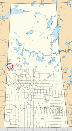
Makwa Lake 129B is an Indian reserve of the Makwa Sahgaiehcan First Nation in Saskatchewan. It is 95 miles northwest of North Battleford. In the 2016 Canadian Census, it recorded a population of 982 living in 226 of its 444 total private dwellings. In the same year, its Community Well-Being index was calculated at 47 of 100, compared to 58.4 for the average First Nations community and 77.5 for the average non-Indigenous community.

Ministikwan 161 is an Indian reserve of the Ministikwan Lake Cree Nation in Saskatchewan. It is 161 kilometres northwest of North Battleford. In the 2016 Canadian Census, it recorded a population of 624 living in 128 of its 150 total private dwellings. In the same year, its Community Well-Being index was calculated at 38 of 100, compared to 58.4 for the average First Nations community and 77.5 for the average non-Indigenous community.

Ministikwan 161A is an Indian reserve of the Ministikwan Lake Cree Nation in Saskatchewan. It is 177 kilometres northwest of North Battleford. In the 2016 Canadian Census, it recorded a population of 223 living in 40 of its 42 total private dwellings. In the same year, its Community Well-Being index was calculated at 35 of 100, compared to 58.4 for the average First Nations community and 77.5 for the average non-Indigenous community.
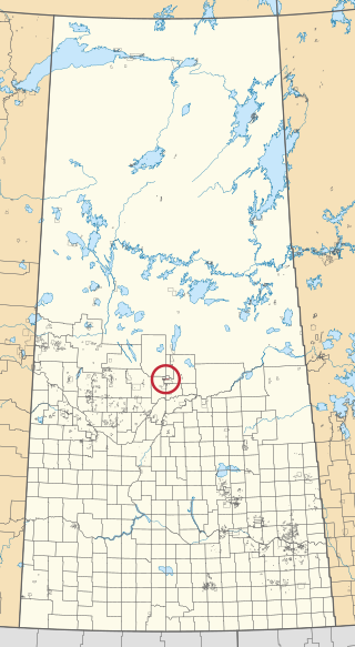
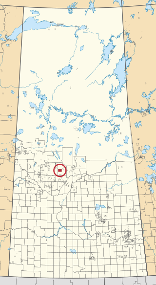
Montreal Lake 106B is an Indian reserve of the Montreal Lake Cree Nation in Saskatchewan. It is adjacent to Little Red River 106C and 39 kilometres (24 mi) north of Prince Albert. In the 2016 Canadian Census, it recorded a population of 442 living in 113 of its 118 total private dwellings. In the same year, its Community Well-Being index was calculated at 47 of 100, compared to 58.4 for the average First Nations community and 77.5 for the average non-Indigenous community.

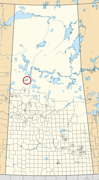
Morin Lake 217 is an Indian reserve of the Lac La Ronge Indian Band in Saskatchewan. It is 24 kilometres east of Lac la Ronge. In the 2016 Canadian Census, it recorded a population of 577 living in 135 of its 155 total private dwellings. In the same year, its Community Well-Being index was calculated at 45 of 100, compared to 58.4 for the average First Nations community and 77.5 for the average non-Indigenous community.

Muscowpetung 80 is an Indian reserve of the Muscowpetung First Nation in Saskatchewan. It is 31 kilometres west of Fort Qu'Appelle along the south-west shore of Pasqua Lake, which is one of four Fishing Lakes. In the 2016 Canadian Census, it recorded a population of 275 living in 87 of its 112 total private dwellings. In the same year, its Community Well-Being index was calculated at 54 of 100, compared to 58.4 for the average First Nations community and 77.5 for the average non-Indigenous community.

The Nekaneet Reserve is an Indian reserve of the Nekaneet Cree Nation in Saskatchewan. It is 121 kilometres southwest of Swift Current. In the 2016 Canadian Census, it recorded a population of 182 living in 46 of its 62 total private dwellings. In the same year, its Community Well-Being index was calculated at 58 of 100, compared to 58.4 for the average First Nations community and 77.5 for the average non-Indigenous community.
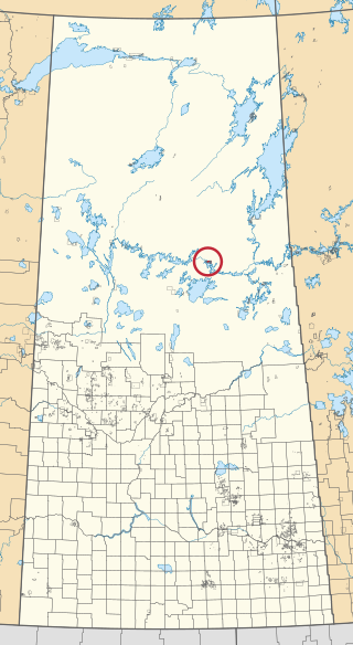
Shoal Lake 28A is an Indian reserve of the Shoal Lake Cree Nation in Saskatchewan. It is 92 kilometres east of Nipawin. In the 2016 Canadian Census, it recorded a population of 424 living in 115 of its 118 total private dwellings. In the same year, its Community Well-Being index was calculated at 46 of 100, compared to 58.4 for the average First Nations community and 77.5 for the average non-Indigenous community.

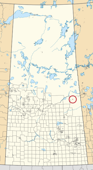
Sturgeon Weir 184F is an Indian reserve of the Peter Ballantyne Cree Nation in Saskatchewan. It is 55 kilometres southeast of Flin Flon. In the 2016 Canadian Census, it recorded a population of 81 living in 20 of its 26 total private dwellings. In the same year, its Community Well-Being index was calculated at 51 of 100, compared to 58.4 for the average First Nations community and 77.5 for the average non-Indigenous community.

Wa-pii-moos-toosis 83A is an Indian reserve of the Star Blanket Cree Nation in Saskatchewan. In 2016, its Community Well-Being index was calculated at 61 of 100, compared to 58.4 for the average First Nations community and 77.5 for the average non-Indigenous community. The name of the locality means "White Calf".