East Branch Fishing Creek is a tributary of Fishing Creek in Columbia County and Sullivan County, Pennsylvania, in the United States. It is 4.4 miles (7.1 km) long. The stream and its tributaries are acidic and contain aluminum. The area in the vicinity was first settled in the late 18th century.
Wallace Run is a tributary of Bald Eagle Creek in Centre County, Pennsylvania, in the United States. It is 12.1 miles (19.5 km) long and is a low-alkalinity stream. The stream flows through Union Township and Boggs Township in Centre County. Most of the watershed is in Boggs Township. The North Branch of Wallace Run is one tributary of the stream. The watershed has an area of 24 square miles (62 km2). Oaks, maples, ash trees, birches, hemlocks, and rhododendrons all exist in the upper reaches of the stream, which is mostly forested. The lower reaches of the stream are mostly developed.
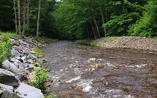
West Branch Fishing Creek is one of the northernmost major tributaries of Fishing Creek in Sullivan County, Pennsylvania and Columbia County, Pennsylvania, in the United States. It is 11.1 miles (17.9 km) long and flows through Davidson Township, Sullivan County and Sugarloaf Township, Columbia County. The creek's watershed has an area of 33.5 square miles, nearly all of which is forested land.
Chimneystack Run is a tributary of Coles Creek in Columbia County, Pennsylvania, in the United States. It is approximately 1.8 miles (2.9 km) long and flows through Sugarloaf Township. The watershed of the stream has an area of 1.07 square miles (2.8 km2). The stream's headwaters are located between Red Rock Mountain and Central Mountain. It has no named tributaries, but one unnamed tributary. Chimneystack Run is named after Chimneystack Rock. Wild trout inhabit the stream. Glaciation has affected the geography and geology in its vicinity.
Rough Run is a tributary of West Branch Fishing Creek in Sullivan County and Columbia County, in Pennsylvania, in the United States. It is approximately 1.3 miles (2.1 km) long and flows through Davidson Township in Sullivan County and Sugarloaf Township in Columbia County. The watershed of the stream has an area of 0.72 square miles (1.9 km2). Glacial till and bedrock consisting of shale and sandstone can be found along the stream. It is named for the speed of its waters and the foliage along the sides of the stream.
Peterman Run is a tributary of West Branch Fishing Creek in Sullivan County and Columbia County, in Pennsylvania, in the United States. It is approximately 1.7 miles (2.7 km) long and flows through Davidson Township in Sullivan County and Sugarloaf Township in Columbia County. The watershed of the stream has an area of 0.41 square miles (1.1 km2). Glacial till and bedrock consisting of shale and sandstone can be found along the stream. It is considered to be impaired by atmospheric deposition and metals.

Painter Run is a tributary of West Branch Fishing Creek in Sullivan County, Pennsylvania, in the United States. It is approximately 4.5 miles (7.2 km) long and flows through Davidson Township. The watershed of the stream has an area of 5.20 square miles (13.5 km2). It has one named tributary, which is known as Oxhorn Run and one unnamed tributary. Painter Run is slightly acidic, with pH values ranging from 5.99 to 6.88. The stream is in a narrow valley with several ridges nearby. Sandstone of the Pocono Formation occurs near it. At least two bridges have been constructed over the stream. Its unnamed tributary is considered to be Class A Wild Trout Waters.
Shingle Mill Run is a tributary of West Branch Fishing Creek in Sullivan County, Pennsylvania, in the United States. It is approximately 2.4 miles (3.9 km) long and flows through Davidson Township. The watershed of the stream has an area of 2.60 square miles (6.7 km2). The stream has one named tributary, Bearwallow Run. Shingle Mill Run is designated as an Exceptional Value stream and has a population of native trout. The stream has high water quality and is slightly acidic. Boulder Colluvium and bedrock consisting of sandstone and shale can be found near the stream.
Hemlock Run is a tributary of West Branch Fishing Creek in Sullivan County, Pennsylvania, in the United States. It is approximately 1.8 miles (2.9 km) long and flows through Davidson Township. The stream has three unnamed tributaries. Its watershed has an area of 1.28 square miles (3.3 km2). Wisconsinan Till Moraine, Wisconsinan Bouldery Till, Wisconsinan Flow-Till, and Wisconsinan Till all occur near the stream.
Laurel Run is a tributary of West Branch Fishing Creek in Sullivan County, Pennsylvania, in the United States. It is approximately 1.2 miles (1.9 km) long and flows through Davidson Township. The stream is in the United States Geological Survey quadrangle of Elk Grove. Wisconsinan Flow-Till, Boulder Colluvium, Wisconsinan Till Moraine, alluvium, and alluvial fan occur in the vicinity of the stream, as does bedrock consisting of sandstone and shale. The southern terminus of the late Wisconsinan glaciation is also in the area. A wood plank bridge on stone masonry abutment walls crosses the stream.
Long Run is a tributary of Elk Run in Sullivan County, Pennsylvania, in the United States. It is approximately 2.4 miles (3.9 km) long and flows through Davidson Township. The stream's watershed has an area of 1.92 square miles (5.0 km2). It has no named tributaries, but four unnamed tributaries. The stream is considered by the Pennsylvania Department of Environmental Protection to be impaired by atmospheric deposition and metals. Wisconsinan Bouldery Till, Wisconsinan Till, and bedrock consisting of sandstone and shale occur in the vicinity of it.
Hog Run is a tributary of Elk Run in Sullivan County, Pennsylvania, in the United States. It is approximately 2.0 miles (3.2 km) long and flows through Davidson Township. The watershed of the stream has an area of 1.05 square miles (2.7 km2). The stream is considered to be impaired by atmospheric deposition and metals. Wisconsinan Ice-Contact Stratified Drift, Wisconsinan Till, and bedrock consisting of shale and sandstone occur in the stream's vicinity.
Gallows Run is a tributary of Elk Run in Sullivan County, Pennsylvania, in the United States. It is approximately 0.7 miles (1.1 km) long and flows through Davidson Township. The watershed of the stream has an area of 0.50 square miles (1.3 km2). The stream meets the standards of the Pennsylvania Department of Environmental Protection. Wisconsinan Till, Wisconsinan Bouldery Till, and bedrock consisting of sandstone and shale occur in the vicinity of the stream. There is also a patch of wetland in the area.

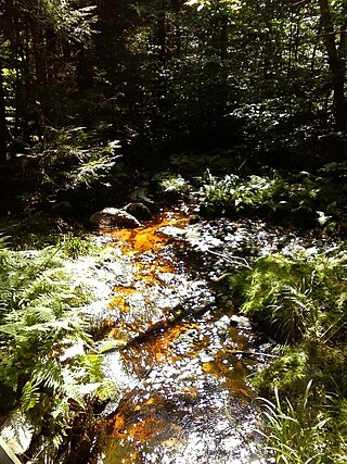
Oxhorn Run is a tributary of Painter Run in Sullivan County, Pennsylvania, in the United States. It is approximately 1.8 miles (2.9 km) long and flows through Davidson Township. The watershed of the stream has an area of 0.87 square miles (2.3 km2). The stream is considered to be impaired by atmospheric deposition and pH. Wisconsinan Ice-Contact Stratified Drift, Wisconsinan Till, and bedrock consisting of sandstone and shale occur in its vicinity.
Rocky Run is a tributary of the Susquehanna River in Luzerne County, Pennsylvania, in the United States. It is approximately 2.3 miles (3.7 km) long and flows through Salem Township. The watershed of the stream has an area of 1.83 square miles (4.7 km2). In the early 1900s, the stream had a high level of water quality and was proposed for use as a water supply. The construction of a dam on it was proposed, but no formal plans were ever made. There are coal mines in the watershed, but they have been abandoned since the late 1800s. Wisconsinan Till, Wisconsinan Ice-Contact Stratified Drift, Boulder Colluvium, Wisconsinan Bouldery Till, coal dumps, and bedrock consisting of sandstone and shale all occur in the watershed. The drainage basin is designated as a Coldwater Fishery.
Slip Run is a tributary of West Branch Fishing Creek in Sullivan County, Pennsylvania, in the United States. It is approximately 1.1 miles (1.8 km) long and flows through Davidson Township. The watershed of the stream has an area of 0.53 square miles (1.4 km2). Wild trout naturally reproduce within the stream. Surficial geology in the area mainly consists of alluvium, Boulder Colluvium, Wisconsinan Till Moraine, Wisconsinan Till, and bedrock consisting of sandstone and shale.
Espy Run is a tributary of Nanticoke Creek in Luzerne County, Pennsylvania, in the United States. It is approximately 2.4 miles (3.9 km) long and flows through Nanticoke and Hanover Township. The watershed of the stream has an area of 3.14 square miles (8.1 km2). The stream is affected by abandoned mine drainage and has been affected by sewage in the past. The Espy Run Wetlands and the Espy Run discharge are in the stream's vicinity. The surficial geology in the area consists of urban land, coal dumps, surface mining land, Wisconsinan Till, Wisconsinan Ice-Contact Stratified Drift, and bedrock.
Lake Run is a tributary of Roaring Brook in Lackawanna County, Pennsylvania, in the United States. It is approximately 1.6 miles (2.6 km) long and flows through Covington Township. The watershed of the stream has an area of 3.44 square miles (8.9 km2). It has one named tributary, which is known as Emerson Run. Lake Run is considered to be Class A Wild Trout Waters. The surficial geology in its vicinity consists of Wisconsinan Ice-Contact Stratified Drift, Wisconsinan Till, Boulder Colluvium, alluvium, bedrock, sand and gravel pits, fill, wetlands, peat bogs, and a lake.
South Branch Bowman Creek is a tributary of Bowman Creek in Luzerne County, Pennsylvania, in the United States. It is approximately 3.0 miles (4.8 km) long and flows through Fairmount Township and Ross Township. The watershed of the creek has an area of 3.92 square miles (10.2 km2). The surficial geology in its vicinity consists of alluvial fan, alluvium, Wisconsinan Ice-Contact Sratified Drift, fill, lakes, Boulder Colluvium, Wisconsinan Till, Wisconsinan Bouldery Till, wetlands, and bedrock. Most of the creek is in Ricketts Glen State Park. It has one named tributary, which is known as Cherry Run. The creek's watershed is designated as a High-Quality Coldwater Fishery and a Migratory Fishery.

West Branch Little Muncy Creek is a tributary of Little Muncy Creek in Sullivan County and Lycoming County, in Pennsylvania, in the United States. It is approximately 3.5 miles (5.6 km) long and flows through Davidson Township in Sullivan County and Franklin Township and Jordan Township in Lycoming County. The watershed of the creek has an area of 4.33 square miles (11.2 km2). The creek has one named tributary, which is known as West Creek. The surficial geology in the vicinity of West Branch Little Muncy Creek includes alluvium, bedrock, fill, Wisconsinan and Reworked Illinoian Till, Wisconsinan Till, Wisconsinan Flow-Till, Wisconsinan Till Moraine, and Boulder Colluvium. The creek designated as a Coldwater Fishery and a Migratory Fishery and is being considered for addition to the wild trout waters list of the Pennsylvania Fish and Boat Commission.
