
Mam Tor is a 517 m (1,696 ft) hill near Castleton in the High Peak of Derbyshire, England. Its name means "mother hill", so called because frequent landslips on its eastern face have resulted in a multitude of "mini-hills" beneath it. These landslips, which are caused by unstable lower layers of shale, also give the hill its alternative name of Shivering Mountain.

Skirrid Fawr, often referred to as just the Skirrid, is an easterly outlier of the Black Mountains in Wales. It forms the easternmost part of the Brecon Beacons National Park. The smaller hill of Ysgyryd Fach or "Little Skirrid" lies about 2+1⁄2 miles south.

The Carneddau are a group of mountains in Snowdonia, Wales. They include the largest contiguous areas of high ground in Wales and England, as well as six or seven of the highest peaks in the country—the Fifteen Peaks. The range also encloses a number of lakes such as Llyn Cowlyd and Llyn Eigiau, and the Aber Falls waterfall. It is delimited by the Irish Sea to the north, the Conwy valley to the east, and by the A5 road from Betws-y-Coed to Bethesda to the south and west. The area covers nearly 200 square kilometres (80 sq mi), about 10% of the area of Snowdonia. The area is bordered by three main roads—the A55, the A5 to the south and the A470 to the east.

The Black Mountains are a group of hills spread across parts of Powys and Monmouthshire in southeast Wales, and extending across the England–Wales border into Herefordshire. They are the easternmost of the four ranges of hills that comprise the Brecon Beacons national park, and are frequently confused with the westernmost, which is known as the Black Mountain. The Black Mountains may be roughly defined as those hills contained within a triangle defined by the towns of Abergavenny in the southeast, Hay-on-Wye in the north and the village of Llangors in the west. Other gateway towns to the Black Mountains include Talgarth and Crickhowell. The range of hills is well known to walkers and ramblers for the ease of access and views from the many ridge trails, such as that on the Black Hill in Herefordshire, at the eastern edge of the massif. The range includes the highest public road in Wales at Gospel Pass, and the highest point in southern England at Black Mountain.

Radnor Forest is a rock dome composed of Silurian shales, mudstones and limestone in the historic county of Radnorshire, Powys, Mid Wales. It is a forest in the medieval sense of the word. It lies within the Welsh Marches region since Offa's Dyke lies nearby to the east.

Fan Brycheiniog is the highest peak at a height of 802.5 metres (2,633 ft) in the Black Mountain region of the Brecon Beacons National Park in southern Wales. There is a trig point at the peak and on the edge of the escarpment, and nearby, a stone shelter with an inner seat. It lies just inside the historic county of Brecknockshire which gives the mountain its Welsh name. A subsidiary top, less than a kilometre from the summit along the ridge to the northwest, is the highest point of the neighbouring county of Carmarthenshire. Fan Brycheiniog is also within the Fforest Fawr Geopark designated in 2005 in recognition of the area's geological heritage. The views of the moorland and open country to the north are spectacular when the weather is clear, and reveals the isolation of the range, especially when compared with the more popular Pen y Fan range to the east.
The Black Mountain is a mountain range in South, Mid and West Wales, straddling the county boundary between Carmarthenshire and Powys, and forming the westernmost range of the Brecon Beacons National Park. Its highest point is Fan Brycheiniog at 802 metres or 2,631 ft. The Black Mountain also forms a part of the Fforest Fawr Geopark.
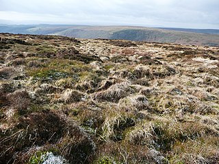
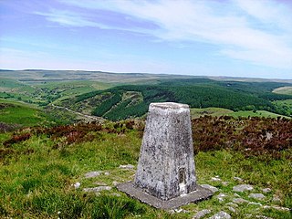
Coity Mountain is a flat-topped mountain in the South Wales Valleys, between Blaenavon and Abertillery. The highest points of both Torfaen and Blaenau Gwent unitary authorities are at the summit of Coity Mountain. The summit is also known as Twyn Ffynhonnau Goerion. Some 2 km (1 mi) to the southeast lies a major subsidiary top of the hill, Mynydd Varteg Fawr (549m) at the southeastern end of whose broad ridge is a trig point at 544m. A few hundred metres to the southeast of this summit is a memorial known as the Dog Stone which commemorates Carlo the Red Setter, a dog shot accidentally by his master while hunting on the 12 August 1864. Co-ordinates for the Dog Stone 51.45'15.58N 3.05'08.81W. Other notable tops include those of Mulfran (524m) which overlooks the town of Brynmawr and Mynydd James immediately east of the town of Blaina.

Longtown is a linear village and parish in Herefordshire, England. The parish includes the village of Clodock and had a population in mid-2010 of 543, increasing to 620 at the 2011 Census.
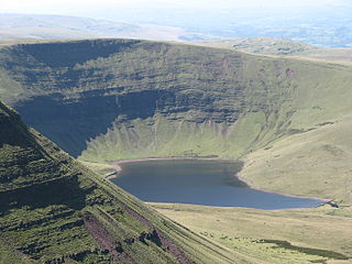
Llyn y Fan Fach is a lake of approximately 10 hectares on the northern margin of the Black Mountain in Carmarthenshire, South Wales and lying within the Brecon Beacons National Park. The lake lies at an altitude of approximately 1,660 feet (510 m), immediately to the north of the ridge of the Carmarthen Fans. It is the smaller of two lakes within this mountain massif: the slightly larger Llyn y Fan Fawr is about 2 miles (3.2 km) to the east.

Pen Cerrig-calch is a subsidiary summit of Waun Fach in the Black Mountains in the Brecon Beacons National Park in southern Powys, Wales. Its summit, at a height of 701 m (2,300 ft), is marked by a trig point. The peak sits high above the River Usk valley as it narrows above the small town of Crickhowell. The views from here are wide-ranging and extend as far as the Beacons themselves to the west. A ridge runs off to the northwest and the shoulder of Pen Gloch-y-pibwr then turns north to the secondary top of Pen Allt-mawr whose peak at 719m is also crowned by a trig point.

Fan Hir is a peak at the eastern end of the Black Mountain in the Brecon Beacons National Park in southern Wales. It is a subsidiary summit of Fan Brycheiniog. It falls within the county of Powys and is also a part of the traditional area of Fforest Fawr. Its Welsh name means "long peak", a fitting description, particularly if seen from the east when its steep eastern face is seen to advantage. It is about 2.5 miles or 4 km long and faces east. Its summit is 2490 feet above sea level. Fan Hir is separated from its higher neighbour to the north-west, Fan Brycheiniog by a col known as Bwlch Giedd, where a path rises from Llyn y Fan Fawr via a stone staircase.

Waun Lefrith is a top of Picws Du and is also the westernmost of the Carmarthen Fans, a group of peaks within the Black Mountain of the Brecon Beacons National Park. It lies within Carmarthenshire, Wales. The summit plateau of the mountain reaches a height of 2221 feet above sea level. Picws Du and Fan Foel are the other, higher summits of the Carmarthen Fans. The glacial lake of Llyn y Fan Fach dominates the panorama to the north of the peak. Beyond the lake to the north lies the Usk Reservoir and then the Cambrian Mountains on the horizon. Swansea Bay and the Bristol Channel are visible to the south across the undulating dip slope of the mountain. The Towy (Tywi) valley lies to the west, with Llandovery and Llandeilo as important market towns nearest to the hills.

Picws Du is the second highest peak of the Carmarthen Fans in the Carmarthenshire section of the Black Mountain in the west of the Brecon Beacons National Park in south Wales. The highest peak is Fan Foel immediately next along the ridge and it is a subsidiary summit of Fan Brycheiniog. Picws Du falls within Fforest Fawr Geopark and its prominent summit is marked by a large Bronze Age round barrow at a height of 2457 feet above sea level. Waun Lefrith is the other, lower summit of the Carmarthen Fans situated to the west. The peak overlooks the glacial lake of Llyn y Fan Fach in the cwm below. As the peak sits on the edge of the escarpment on a ridge which juts out into the valley below, the views from the summit are panoramic and extensive. The views to the north are especially impressive when the weather is clear, looking towards the Cambrian Mountains, Mynydd Epynt and Brecon. Swansea and the Bristol Channel can just be seen on the horizon to the south, across the gently falling dip slope. Pen y Fan and Corn Du are distinctive landmarks seen directly to the east across Fforest Fawr.

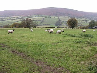
Bryn Arw is a hill in the Black Mountains of the Brecon Beacons National Park in Monmouthshire, south Wales. It lies 4 km north of the town of Abergavenny and 1.5 miles west of the village of Llanvihangel Crucorney. Its summit at 384m above sea level is the more northerly of two tops which lie on the crest of a slightly arcuate north-south ridge which drops away to the south at first gently and then sharply. The hill is isolated from the main mass of the range by the valleys of Cwm Coed-y-cerig to the north and by Cwm Brynarw to the west. It is a Marilyn.
Hatterrall Hill is a rounded peak in the Black Mountains which sits on the Wales-England border, partly in Monmouthshire, Wales and partly in Herefordshire, England. Its summit at 531m is the high point of a peaty plateau which falls away steeply on all sides. Broad ridges run to the north, the southeast and southwest. To the north the ridge dips to a col at around 485m elevation before rising gradually over several kilometres towards Crib y Garth / Black Hill and Hay Bluff. The ridge to the southwest ends abruptly at the sheer cliff known as the Darren below which is a considerable landslip area extending south to the hamlet of Cwmyoy with its mis-shapen church. The Welsh part of the hill falls within the Brecon Beacons National Park.

The Hatterrall Ridge is a ridge in the Black Mountains forming the border between Powys and Monmouthshire in Wales and Herefordshire in England. The ridge is about 10 miles (16 km) long, and is followed by the Offa's Dyke Path. On the west side of the ridge is the Vale of Ewyas, and on the east side is the Olchon Valley and Black Hill. The western side of the ridge falls within the Brecon Beacons National Park. Much of the northern part of the ridge is a broad whaleback, but it narrows down considerably further south, and especially near to Llanthony Priory in the Vale of Ewyas to the west of the mountain. There is a large and prominent landslip on the eastern side of the mountain here, known as Black Darren, where a large slice of the rocks has fallen away from the main mass of the hill.
The geology of Monmouthshire in southeast Wales largely consists of a thick series of sedimentary rocks of different types originating in the Silurian, Devonian, Carboniferous, Triassic and Jurassic periods.

Hay Bluff is a prominent hill at the northern tip of the Black Mountains, an extensive upland massif which straddles the border between south-east Wales and England. The mountain sits at the point where the main northeast-facing escarpment of the Black Mountains meets the northwest facing escarpment, the next peak to the west being Twmpa. The flat summit of Hay Bluff which is marked by a triangulation pillar at a height of 677 metres (2,221 ft) overlooks the middle Wye Valley and the book town of Hay-on-Wye.
Mynydd Mallaen is an expansive plateau to the northwest of Cilycwm in northeast Carmarthenshire, Wales. It forms part of the Cambrian Mountains massif, and is north-west of the Black Mountain (range) in the Brecon Beacons. It takes the form of an undulating plateau with steep slopes dropping away to the Towy valley to the east and those of the Gwenffrwd, Nant Melyn and Afon Cothi to the north and west. Its highest point of 1516 feet or 462m at OS grid reference SN 723455 is surmounted by two Bronze Age cairns known as Crugiau Merched. Caeo Forest covers much of the southern flanks of the hill and smaller forests also cover its eastern slopes. Much of the native woodland consists of sessile oak groves, especially on the valley sides. The human population is very low, being restricted to hill farms engaged in sheep farming, and some holiday cottages.


