William Lawson, MLC was an English-born Australian explorer, land owner, grazier and politician who migrated to Sydney, New South Wales in 1800. Along with his close friends and colleagues Gregory Blaxland and William Wentworth, he pioneered the first successful crossing of the Blue Mountains by European settlers.

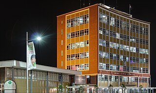
Ryde is a suburb of Sydney, New South Wales, Australia. Ryde is located 13 km north-west of the Sydney Central Business District and 8 km east of Parramatta. Ryde is the administrative centre of the local government area of the City of Ryde and part of the Northern Sydney region. It lies on the north bank of the Parramatta River.

Lane Cove is a suburb on the Lower North Shore of Sydney, in the state of New South Wales, Australia. Lane Cove is nine kilometres north-west of the Sydney central business district and is the administrative centre for the local government area of the Lane Cove Council. Lane Cove West and Lane Cove North are separate suburbs.

Boggabilla is a small town in the far north of inland New South Wales, Australia in Moree Plains Shire. At the 2016 census, the town had a population of 551, of which 63% identified as Aboriginal or Torres Strait Islander descent.
Dundas is a suburb of Sydney, New South Wales, Australia. Dundas is located 21 kilometres north-west of the Sydney central business district, in the local government area of the City of Parramatta, and the electoral division of Bennelong. Dundas is a leafy green suburb, notably due to its centrepiece The Ponds Walk, which follows the Ponds Subiaco Creek. Dundas is part of the Northern Sydney and Greater Western Sydney regions.

The Lane Cove Council is a local government area located on the Lower North Shore of Sydney, New South Wales, Australia. The administrative seat of Lane Cove is located 10 kilometres (6.2 mi) north-west of the Sydney central business district.

Prestons is a suburb of Sydney, in the state of New South Wales, Australia 37 kilometres south-west of the Sydney central business district, in the local government area of the City of Liverpool.

The locality and suburb of Gymea Bay are located in southern Sydney, in the state of New South Wales, Australia. Gymea Bay is 27 kilometres (17 mi) south of the Sydney central business district, in the local government area of the Sutherland Shire. The postcode is 2227, which it shares with the adjacent suburb of Gymea. The Gymea Bay locality takes its name from the adjoining Gymea Bay, a small bay on the north side of the Port Hacking estuary).
Denistone East is a suburb in Northern Sydney, Australia. Denistone East is 16 kilometres north-west of the Sydney central business district in the local government area of the City of Ryde. Denistone and Denistone West are separate suburbs; Denistone East was gazetted as a suburb in its own right on 5 February 1999.

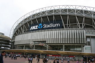
Sydney Olympic Park is a suburb of Greater Western Sydney, located 13 kilometres west of the Sydney central business district, in the local government area of the City of Parramatta Council. It is commonly known as Olympic Park but officially named Sydney Olympic Park. The area was originally part of the suburb of Homebush Bay, but was designated a suburb in its own right in 2009. The names "Homebush Bay" and, sometimes, "Homebush" are still used colloquially as a metonym for Stadium Australia as well as the Olympic Park precinct as a whole, but Homebush is a separate suburb to the southeast.

The Lane Cove Tunnel is an A$1.1 billion, 3.6 km twin-tunnel tollway in Sydney, Australia, which connects the M2 Motorway at North Ryde with the Gore Hill Freeway at Artarmon. It is owned by toll road operator Transurban and forms part of the M2 and the 110 km Sydney Orbital Network.

Macdonaldtown is an urban place in Sydney, in the state of New South Wales, Australia. It is 4 kilometres south-west of the Sydney central business district, adjacent to the suburbs of Newtown, Eveleigh and Erskineville. Macdonaldtown is part of the local government area of the City of Sydney and informally part of the region of the Inner West. The locality is around Macdonaldtown railway station, on the Inner West line of the Sydney Trains network.

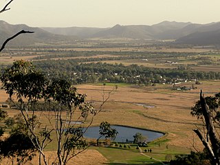
Broke is a village of approximately 292 people in the Hunter Region of New South Wales, Australia in Singleton Shire. It is located 157 kilometres (98 mi) to the north of Sydney on the original early colonial road from Sydney to Singleton.

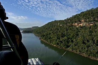
Cheero Point is a residential suburb of the Central Coast region of New South Wales, Australia, located on the west bank of the Mooney Mooney Creek 49 kilometres (30 mi) north of Sydney. It is part of the Central Coast Council local government area.

Epping Road is a 10-kilometre-long (6.2 mi) arterial road located on the North Shore of Sydney, New South Wales, Australia. Epping Road is a major route linking the lower North Shore and Sydney central business district to the north western suburbs of the upper North Shore and Hills District of metropolitan Sydney, being a major access road to the commercial, industrial and university areas of North Ryde and Macquarie Park.
Suburbs and localities are the names of geographic subdivisions in Australia, used mainly for address purposes. The term locality is used in rural areas, while the term suburb is used in urban areas. Australian postcodes closely align with the boundaries of localities and suburbs.
Deanes Coaches was an Australian bus company operating route bus services and charter coaches on Sydney's North Shore.
Blaxland Creek, a watercourse that is part of the Hawkesbury–Nepean catchment, is located in Greater Western Sydney, Australia.
Gore Creek, an urban watercourse that is part of the Parramatta River catchment, is located in Northern Suburbs region of Sydney, Australia.
Longueville Motor Bus Company was an Australian bus company operating route bus services on Sydney's Lower North Shore.


