
Cochise County is a county in the southeastern corner of the U.S. state of Arizona. It is named after Cochise, a Chiricahua Apache who was a key war leader during the Apache Wars.

Sierra Vista is a city in Cochise County, Arizona, United States. According to the 2020 Census, the population of the city is 45,308, and is the 27th most populous city in Arizona. The city is part of the Sierra Vista-Douglas Metropolitan Area, with a 2010 population of 131,346. Fort Huachuca, a U.S. Army post, has been incorporated and is located in the northwest part of the city. Sierra Vista is bordered by the cities of Huachuca City and Whetstone to the north and Sierra Vista Southeast to the South.

Sierra Vista Southeast, often referred to as Hereford or Nicksville, is a census-designated place (CDP) in Cochise County, Arizona, United States. The population was 14,797 at the 2010 census. It includes the neighborhoods Ramsey Canyon, and Sierra Vista Estates within its boundaries.

The Chiricahua Mountains massif is a large mountain range in southeastern Arizona which is part of the Basin and Range province of the west and southwestern United States and northwest Mexico; the range is part of the Coronado National Forest. The highest point, Chiricahua Peak, rises 9,759 feet (2,975 m) above sea level, approximately 6,000 feet (1,800 m) above the surrounding valleys. The range takes its name from the Chiricahua Apaches native to the region.
The Coronado National Forest is a United States National Forest that includes an area of about 1.78 million acres (7,200 km2) spread throughout mountain ranges in southeastern Arizona and southwestern New Mexico.

Mount Lemmon, with a summit elevation of 9,159 feet (2,792 m), is the highest point in the Santa Catalina Mountains. It is located in the Coronado National Forest north of Tucson, Arizona, United States. Mount Lemmon was named for botanist Sara Plummer Lemmon, who trekked to the top of the mountain with her husband and E. O. Stratton, a local rancher, by horse and foot in 1881. Mount Lemmon is also known as Babad Do'ag, or Frog Mountain to the Tohono O'odham. It is home to the southernmost ski destination in the continental United States.

The Coronado National Memorial commemorates the first organized expedition into the Southwest by conquistador Francisco Vásquez de Coronado in 1540. The memorial is located in a natural setting on the Mexico–United States border on the southeast flank of the Huachuca Mountains south of Sierra Vista, Arizona and is bordered to the north and west by Coronado National Forest. Within the memorial is an overlook at Montezuma Pass where the Coronado expedition entered modern Arizona. The memorial confirms the ties that bind the United States and Mexico.

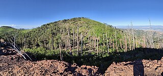
Miller Peak, at 9,470 feet (2,886 m), is the second-highest mountain in Cochise County, Arizona. Located approximately 10 miles south of Sierra Vista, Arizona, it is the highest mountain in the Huachuca mountain range and a popular local hiking destination. The Miller Peak Wilderness encompasses 20,190 acres and is managed by the Coronado National Forest. This is also the most southerly peak and land area to rise above 9,000 feet in the continental United States. The area was affected by the 2011 Monument fire and most of the pine trees seen in older photographs were burned and destroyed. Scrub oak are beginning to replace the areas that were previously covered by pine.

Paradise is a small ghost town located in Cochise County in the U.S. state of Arizona. The town was settled in 1901 in what was then the Arizona Territory. Paradise is also the setting for the first two Postal games.
Chiricahua Peak is a 9,773 feet (2,979 m) peak located in the Chiricahua Mountains of southeastern Arizona, located about 35 miles (56 km) north of the United States–Mexico border. It is the highest summit in the Chiricahua Mountains and the highest point in Cochise County.

The San Pedro River is a northward-flowing stream originating about 10 miles (16 km) south of the international border south of Sierra Vista, Arizona, in Cananea Municipality, Sonora, Mexico. The river starts at the confluence of other streams just east of Sauceda, Cananea. Within Arizona, the river flows 140 miles (230 km) north through Cochise County, Pima County, Graham County, and Pinal County to its confluence with the Gila River, at Winkelman, Arizona. It is the last major, undammed desert river in the American Southwest, and it is of major ecological importance as it hosts two-thirds of the avian diversity in the United States, including 100 species of breeding birds and almost 300 species of migrating birds.
Hereford is a populated place in Cochise County along the San Pedro Riparian National Conservation Area in the southern part of the U.S. state of Arizona. It is southeast of Sierra Vista and is a part of the Sierra Vista-Douglas micropolitan area. The elevation is 4,193 feet at the location of the original townsite at the far eastern end of the unincorporated area; the residential area runs for another 8 miles west from this location, blending into the unincorporated area of Nicksville at an elevation of approximately 4800 feet. Hereford Station Post Office is located at the far western end of Nicksville, at the foot of the Huachuca Mountains.
The Southeastern Arizona Bird Observatory (SABO) is a nonprofit membership-supported scientific and educational organization founded in 1996 in Bisbee, Arizona, USA. The mission of the Southeastern Arizona Bird Observatory is to promote the conservation of the birds of southeastern Arizona, their habitats, and the diversity of species that share those habitats through research, monitoring, and public education. The observatory's founders are Tom Wood and Sheri Williamson, former managers of The Nature Conservancy's Ramsey Canyon Preserve.

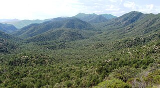
The Huachuca Mountains are part of the Sierra Vista Ranger District of the Coronado National Forest in Cochise County in southeastern Arizona, approximately 70 miles (110 km) south-southeast of Tucson and southwest of the city of Sierra Vista. Included in this area is the highest peak in the Huachucas, Miller Peak, and the region of the Huachucas known as Canelo Hills in eastern Santa Cruz County. The mountains range in elevation from 3,934 feet (1,199 m) at the base to 9,466 feet (2,885 m) at the top of Miller Peak. The second highest peak in this range is Carr Peak, elevation 9,200 feet (2,804 m). The Huachuca Mountain area is managed principally by the United States Forest Service (41%) and the U.S. Army (20%), with much of the rest being private land (32%). Sierra Vista is the main population center.
Baboquivari National Forest was established as the Baboquivari Forest Reserve by the U.S. Forest Service in Arizona on November 5, 1906, with 126,720 acres (512.8 km2). On March 4, 1907, it became a National Forest, and on July 1, 1908, the entire forest was combined with Huachuca National Forest and Tumacacori National Forest to establish Garces National Forest. The name was discontinued.

The Whetstone Mountains is a mountain range in Cochise County, southeastern Arizona.

Carr Peak is the third-highest mountain in Cochise County, Arizona and is the second-highest mountain in the Huachuca Mountains. It rises about 10 miles (16 km) south of Sierra Vista, Arizona. The summit is in the Miller Peak Wilderness on the Coronado National Forest and about 4 miles (6 km) south of the Nature Conservancy's Ramsey Canyon Preserve. The area is well known among birders because of the variety of hummingbird species seen in the area as well as the dozens of southwestern specialties such as Apache pine, Chihuahua pine, ridge-nosed rattlesnake, lesser long-nosed bat and elegant trogon.

The Little Dragoon Mountains, are included in the Douglas Ranger District of Coronado National Forest, in Cochise County, Arizona.

Apache Peak, at 7,714 feet (2,351 m), is the highest peak in the Whetstone Mountains in Cochise County, Arizona. The summit, located in the Coronado National Forest, is a popular local hiking destination. It is located near the Kartchner Caverns State Park, the city of Benson, Interstate 10, and Arizona State Route 90.

Montezuma Peak is a 7,682-foot-elevation (2,341-meter) summit in Cochise County, Arizona, United States.


