Bogton

Last updated

Bogton
Aberdeenshire UK location map.svg
Red pog.svg
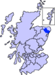
Bogton
Location within Aberdeenshire
OS grid reference NJ6751
Council area
Lieutenancy area
Country Scotland
Sovereign state United Kingdom
Police Scotland
Fire Scottish
Ambulance Scottish
UK Parliament
Scottish Parliament
List of places
UK
Scotland
57°32′N2°33′W / 57.54°N 02.55°W / 57.54; -02.55

Bogton is a rural area in Aberdeenshire, Scotland. [1] [2] To the south is Whitehill Wood and megalithic circle.

The former lodge of Carnousie Castle, near Bogton Former Lodge for Carnousie Castle.jpg
The former lodge of Carnousie Castle, near Bogton

References

  1. Ordnance Survey: Landranger map sheet 29 Banff & Huntly (Portsoy & Turriff) (Map). Ordnance Survey. 2014. ISBN   9780319231043.
  2. "Ordnance Survey: 1:50,000 Scale Gazetteer" (csv (download)). www.ordnancesurvey.co.uk. Ordnance Survey. 1 January 2016. Retrieved 30 January 2016.